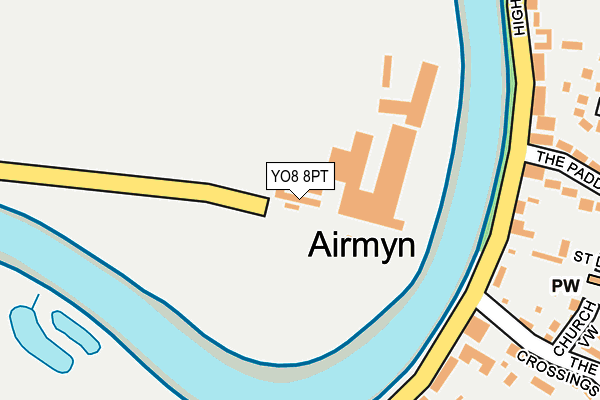
YO8 8PT is located in the Camblesforth & Carlton electoral ward, within the unitary authority of North Yorkshire and the English Parliamentary constituency of Selby and Ainsty. The Sub Integrated Care Board (ICB) Location is NHS Humber and North Yorkshire ICB - 03Q and the police force is North Yorkshire. This postcode has been in use since January 1980.


GetTheData
Source: OS OpenMap – Local (Ordnance Survey)
Source: OS VectorMap District (Ordnance Survey)
Licence: Open Government Licence (requires attribution)
| Easting | 472284 |
| Northing | 425239 |
| Latitude | 53.718565 |
| Longitude | -0.906127 |
GetTheData
Source: Open Postcode Geo
Licence: Open Government Licence
| Country | England |
| Postcode District | YO8 |
| ➜ YO8 open data dashboard ➜ See where YO8 is on a map ➜ Where is Airmyn? | |
GetTheData
Source: Land Registry Price Paid Data
Licence: Open Government Licence
Elevation or altitude of YO8 8PT as distance above sea level:
| Metres | Feet | |
|---|---|---|
| Elevation | 10m | 33ft |
Elevation is measured from the approximate centre of the postcode, to the nearest point on an OS contour line from OS Terrain 50, which has contour spacing of ten vertical metres.
➜ How high above sea level am I? Find the elevation of your current position using your device's GPS.
GetTheData
Source: Open Postcode Elevation
Licence: Open Government Licence
| Ward | Camblesforth & Carlton |
| Constituency | Selby And Ainsty |
GetTheData
Source: ONS Postcode Database
Licence: Open Government Licence
| May 2023 | Other theft | On or near The Crossings | 298m |
| January 2023 | Other theft | On or near The Crossings | 298m |
| May 2022 | Other theft | On or near High Street | 197m |
| ➜ Get more crime data in our Crime section | |||
GetTheData
Source: data.police.uk
Licence: Open Government Licence
| Airmyn High Street (High Street) | Airmyn | 250m |
| Airmyn High Street (High Street) | Airmyn | 266m |
| Airmyn Ferry Lane (Ferry Lane) | Airmyn | 981m |
| Goole Western Road (Western Road) | Goole | 1,363m |
| Airmyn A614 (Rawcliffe Road) | Airmyn | 1,481m |
| Goole Station | 2.6km |
| Rawcliffe Station | 4.9km |
GetTheData
Source: NaPTAN
Licence: Open Government Licence
GetTheData
Source: ONS Postcode Database
Licence: Open Government Licence


➜ Get more ratings from the Food Standards Agency
GetTheData
Source: Food Standards Agency
Licence: FSA terms & conditions
| Last Collection | |||
|---|---|---|---|
| Location | Mon-Fri | Sat | Distance |
| Airmyn Post Office | 16:15 | 09:00 | 263m |
| Vikings Hotel | 17:30 | 11:00 | 1,439m |
| Rawcliffe Road | 17:30 | 09:45 | 1,551m |
GetTheData
Source: Dracos
Licence: Creative Commons Attribution-ShareAlike
| Facility | Distance |
|---|---|
| Airmyn Cricket Club (Closed) Rear Of Percy Arms, High Street, Airmyn, Goole Grass Pitches | 611m |
| Airmyn Memorial Hall Woodland Way, Airmyn, Goole Sports Hall, Grass Pitches | 618m |
| West Park (Goole) Airmyn Road, Goole Grass Pitches | 1.3km |
GetTheData
Source: Active Places
Licence: Open Government Licence
| School | Phase of Education | Distance |
|---|---|---|
| Airmyn Park Primary School Percy Drive, Airmyn, Goole, DN14 8NZ | Primary | 454m |
| Parkside Primary School Western Road, Goole, DN14 6RQ | Primary | 1.4km |
| Goole Academy Centenary Road, Goole, DN14 6AN | Secondary | 1.9km |
GetTheData
Source: Edubase
Licence: Open Government Licence
| Risk of YO8 8PT flooding from rivers and sea | Low |
| ➜ YO8 8PT flood map | |
GetTheData
Source: Open Flood Risk by Postcode
Licence: Open Government Licence
The below table lists the International Territorial Level (ITL) codes (formerly Nomenclature of Territorial Units for Statistics (NUTS) codes) and Local Administrative Units (LAU) codes for YO8 8PT:
| ITL 1 Code | Name |
|---|---|
| TLE | Yorkshire and The Humber |
| ITL 2 Code | Name |
| TLE2 | North Yorkshire |
| ITL 3 Code | Name |
| TLE22 | North Yorkshire CC |
| LAU 1 Code | Name |
| E07000169 | Selby |
GetTheData
Source: ONS Postcode Directory
Licence: Open Government Licence
The below table lists the Census Output Area (OA), Lower Layer Super Output Area (LSOA), and Middle Layer Super Output Area (MSOA) for YO8 8PT:
| Code | Name | |
|---|---|---|
| OA | E00142063 | |
| LSOA | E01027884 | Selby 008B |
| MSOA | E02005816 | Selby 008 |
GetTheData
Source: ONS Postcode Directory
Licence: Open Government Licence
| DN14 8LD | High Street | 282m |
| DN14 8LW | Church View | 296m |
| DN14 8LF | High Street | 297m |
| DN14 8LU | The Paddock | 297m |
| DN14 8LB | High Street | 309m |
| DN14 8LX | Park Close | 314m |
| DN14 8JJ | St Davids View | 341m |
| DN14 8LE | The Crossings | 344m |
| DN14 8LP | Parsons Walk | 379m |
| DN14 8LQ | Park Road | 392m |
GetTheData
Source: Open Postcode Geo; Land Registry Price Paid Data
Licence: Open Government Licence