
House prices and property data
GetTheData provides house price data and property information for individual properties.
Our information is sourced from official UK government agencies, and includes:
- Sales history, including price achieved and date sold.
- Property value vs. the comparable average house price over time.
- Estimate of current property value.
- Property size vs. comparable properties.
- Plot and title map.
- Location map.
To find a property, start typing the property's address into the search bar at the top of the page.
Alternatively you can drill down by place (detached properties only).
Example properties
The below example properties are selected at random. Click a link to see the property information for that property.
- 28, WIMBORNE CRESCENT, SULLY, PENARTH, CF64 5SR
- 38, NORTH ROAD, EGREMONT, CA22 2PR
- 4, LEWES ROAD, RIDGEWOOD, UCKFIELD, TN22 5SL
- 1, HARRIER CLOSE, WORSLEY, MANCHESTER, M28 7AH
- 109, WHINLATTER ROAD, WHITEHAVEN, CA28 8DJ
Example property price chart
For each property we have plotted the sales to date, along with the Office for National Statistics' House Price Index (HPI) for that property type and local authority area. Between each sale, we have extrapolated a line to show what the property value might be, at a given point in time, were the property to track the HPI. The example below, selected at random, plots the three sales of 114 WOODLAND ROAD, along with the average price of a semi-detached house in the Leeds local authority area, over time, according to the HPI.

Example property size chart
The property size chart shows the size of the property relative to similar properties of the same property type, and in the same geographical area. The example below, selected at random, shows the distribution of property sizes of terraced houses in West Bridgford, and where 7 SPRING CLOSE lies on that distribution.

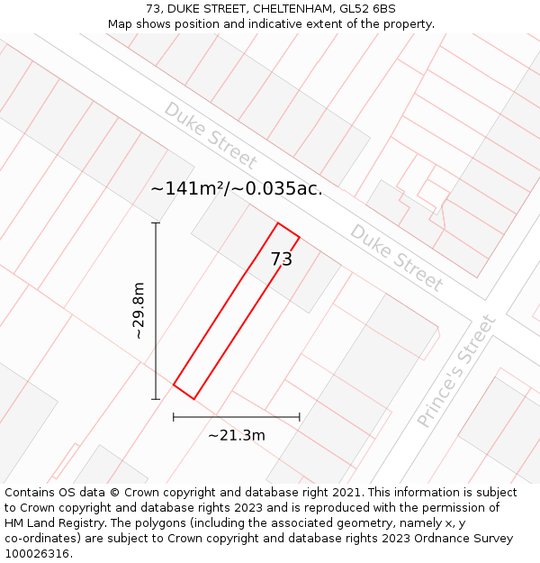
Property plot and title Map
The plot and title map shows the extent of the plot in which the property sits. This may also be the extent of the property title, however this is not always the case, as the title may include further land which is not shown. The example below, selected at random, shows the location of 73 DUKE STREET, an approximate outline of the building(s), and the indicative extent of the property.
Location map
The location map shows the position of the property within its immediate locality. The example below, selected at random, shows the position of No. 167 on THORNTONS CLOSE.


- Contains OS data © Crown copyright and database right (2026)
- Contains Royal Mail data © Royal Mail copyright and Database right (2026)
- Contains National Statistics data © Crown copyright and database right (2026)
- Data produced by Land Registry © Crown copyright (2026)
- Contains Environment Agency data licensed under the Open Government Licence v3.0
- Everything else © GetTheData Publishing Limited (2026)
GetTheData.com is owned and operated by GetTheData Publishing Limited.
Company Number: 11075184 · Registered in England and Wales.
Registered Office: 3rd Floor, 86-90 Paul Street, London, England, EC2A 4NE
By accessing our site you agree to us using cookies, and sharing information about your use of our site, in accordance with our privacy policy.