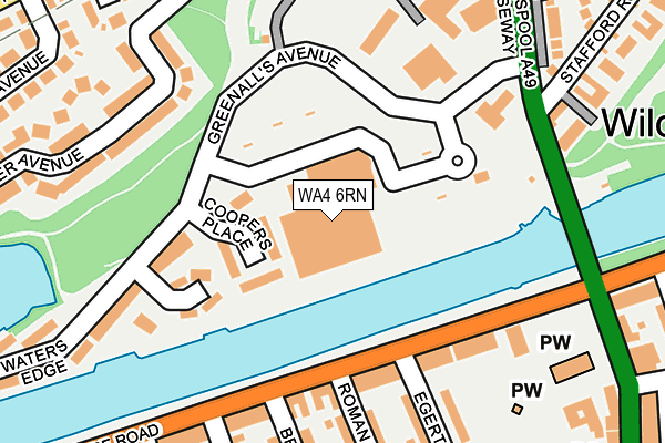
WA4 6RN is located in the Latchford West electoral ward, within the unitary authority of Warrington and the English Parliamentary constituency of Warrington South. The Sub Integrated Care Board (ICB) Location is NHS Cheshire and Merseyside ICB - 02E and the police force is Cheshire. This postcode has been in use since May 1994.


GetTheData
Source: OS OpenMap – Local (Ordnance Survey)
Source: OS VectorMap District (Ordnance Survey)
Licence: Open Government Licence (requires attribution)
| Easting | 361133 |
| Northing | 386451 |
| Latitude | 53.373479 |
| Longitude | -2.585654 |
GetTheData
Source: Open Postcode Geo
Licence: Open Government Licence
| Country | England |
| Postcode District | WA4 |
| ➜ WA4 open data dashboard ➜ See where WA4 is on a map ➜ Where is Warrington? | |
GetTheData
Source: Land Registry Price Paid Data
Licence: Open Government Licence
Elevation or altitude of WA4 6RN as distance above sea level:
| Metres | Feet | |
|---|---|---|
| Elevation | 10m | 33ft |
Elevation is measured from the approximate centre of the postcode, to the nearest point on an OS contour line from OS Terrain 50, which has contour spacing of ten vertical metres.
➜ How high above sea level am I? Find the elevation of your current position using your device's GPS.
GetTheData
Source: Open Postcode Elevation
Licence: Open Government Licence
| Ward | Latchford West |
| Constituency | Warrington South |
GetTheData
Source: ONS Postcode Database
Licence: Open Government Licence
| January 2024 | Violence and sexual offences | On or near Landseer Avenue | 244m |
| November 2023 | Violence and sexual offences | On or near Landseer Avenue | 244m |
| November 2023 | Violence and sexual offences | On or near Landseer Avenue | 244m |
| ➜ Get more crime data in our Crime section | |||
GetTheData
Source: data.police.uk
Licence: Open Government Licence
| Swing Bridge (Ellesmere Road) | Wilderspool | 129m |
| Morrisons (Wilderspool Causeway) | Wilderspool | 234m |
| Francis Road (Ellesmere Road) | Walton | 242m |
| Francis Road (Ellesmere Road) | Walton | 245m |
| Morrisons (Wilderspool Causeway) | Wilderspool | 265m |
| Warrington Bank Quay Station | 1.8km |
| Warrington Central Station | 2.1km |
| Padgate Station | 4.1km |
GetTheData
Source: NaPTAN
Licence: Open Government Licence
GetTheData
Source: ONS Postcode Database
Licence: Open Government Licence


➜ Get more ratings from the Food Standards Agency
GetTheData
Source: Food Standards Agency
Licence: FSA terms & conditions
| Last Collection | |||
|---|---|---|---|
| Location | Mon-Fri | Sat | Distance |
| Ellesmere Road | 17:30 | 11:00 | 148m |
| Greenalls Avenue | 17:30 | 11:00 | 281m |
| Stockton Heath So | 17:30 | 12:00 | 350m |
GetTheData
Source: Dracos
Licence: Creative Commons Attribution-ShareAlike
| Facility | Distance |
|---|---|
| Stockton Heath Primary School West Avenue, Stockton Heath, Warrington Sports Hall, Artificial Grass Pitch | 315m |
| Anytime Fitness (Stockton Heath) Grappenhall Road, Stockton Heath, Warrington Health and Fitness Gym, Studio | 475m |
| Loushers Lane Recreation Ground Loushers Lane, Latchford, Warrington Grass Pitches | 514m |
GetTheData
Source: Active Places
Licence: Open Government Licence
| School | Phase of Education | Distance |
|---|---|---|
| Stockton Heath Primary School West Avenue, Stockton Heath, Warrington, WA4 6HX | Primary | 396m |
| St Thomas' CofE Primary School Parkgate Road, Stockton Heath, Warrington, WA4 2AP | Primary | 672m |
| Priestley College Loushers Lane, Warrington, WA4 6RD | 16 plus | 685m |
GetTheData
Source: Edubase
Licence: Open Government Licence
| Risk of WA4 6RN flooding from rivers and sea | Low |
| ➜ WA4 6RN flood map | |
GetTheData
Source: Open Flood Risk by Postcode
Licence: Open Government Licence
The below table lists the International Territorial Level (ITL) codes (formerly Nomenclature of Territorial Units for Statistics (NUTS) codes) and Local Administrative Units (LAU) codes for WA4 6RN:
| ITL 1 Code | Name |
|---|---|
| TLD | North West (England) |
| ITL 2 Code | Name |
| TLD6 | Cheshire |
| ITL 3 Code | Name |
| TLD61 | Warrington |
| LAU 1 Code | Name |
| E06000007 | Warrington |
GetTheData
Source: ONS Postcode Directory
Licence: Open Government Licence
The below table lists the Census Output Area (OA), Lower Layer Super Output Area (LSOA), and Middle Layer Super Output Area (MSOA) for WA4 6RN:
| Code | Name | |
|---|---|---|
| OA | E00173141 | |
| LSOA | E01012509 | Warrington 018D |
| MSOA | E02002607 | Warrington 018 |
GetTheData
Source: ONS Postcode Directory
Licence: Open Government Licence
| WA4 6NN | Coopers Place | 60m |
| WA4 6DS | Ellesmere Road | 142m |
| WA4 6RL | Wilderspool Crescent | 158m |
| WA4 6RJ | Greenalls Avenue | 171m |
| WA4 6QG | Egerton Mews | 209m |
| WA4 6DX | Roman Road | 212m |
| WA4 6DJ | Landseer Avenue | 216m |
| WA4 6DT | Egerton Street | 226m |
| WA4 6DZ | Ellesmere Road | 235m |
| WA4 6DY | Brackley Street | 246m |
GetTheData
Source: Open Postcode Geo; Land Registry Price Paid Data
Licence: Open Government Licence