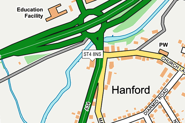
ST4 8NS lies on Stone Road in Stoke-on-trent. ST4 8NS is located in the Hanford, Newstead & Trentham electoral ward, within the unitary authority of Stoke-on-Trent and the English Parliamentary constituency of Stoke-on-Trent South. The Sub Integrated Care Board (ICB) Location is NHS Staffordshire and Stoke-on-Trent ICB - 05W and the police force is Staffordshire. This postcode has been in use since January 1980.


GetTheData
Source: OS OpenMap – Local (Ordnance Survey)
Source: OS VectorMap District (Ordnance Survey)
Licence: Open Government Licence (requires attribution)
| Easting | 386689 |
| Northing | 342643 |
| Latitude | 52.980963 |
| Longitude | -2.199700 |
GetTheData
Source: Open Postcode Geo
Licence: Open Government Licence
| Street | Stone Road |
| Town/City | Stoke-on-trent |
| Country | England |
| Postcode District | ST4 |
| ➜ ST4 open data dashboard ➜ See where ST4 is on a map ➜ Where is Stoke-on-Trent? | |
GetTheData
Source: Land Registry Price Paid Data
Licence: Open Government Licence
Elevation or altitude of ST4 8NS as distance above sea level:
| Metres | Feet | |
|---|---|---|
| Elevation | 100m | 328ft |
Elevation is measured from the approximate centre of the postcode, to the nearest point on an OS contour line from OS Terrain 50, which has contour spacing of ten vertical metres.
➜ How high above sea level am I? Find the elevation of your current position using your device's GPS.
GetTheData
Source: Open Postcode Elevation
Licence: Open Government Licence
| Ward | Hanford, Newstead & Trentham |
| Constituency | Stoke-on-trent South |
GetTheData
Source: ONS Postcode Database
Licence: Open Government Licence
152, STONE ROAD, STOKE-ON-TRENT, ST4 8NS 2004 12 FEB £85,000 |
GetTheData
Source: HM Land Registry Price Paid Data
Licence: Contains HM Land Registry data © Crown copyright and database right 2024. This data is licensed under the Open Government Licence v3.0.
| June 2022 | Other theft | On or near Pedestrian Subway | 92m |
| June 2022 | Violence and sexual offences | On or near Diarmid Road | 244m |
| June 2022 | Violence and sexual offences | On or near Diarmid Road | 244m |
| ➜ Get more crime data in our Crime section | |||
GetTheData
Source: data.police.uk
Licence: Open Government Licence
| Mayne Street (Stone Road) | Hanford | 36m |
| Mayne Street (Stone Road) | Hanford | 42m |
| Mayne Street (Stone Road) | Hanford | 43m |
| Church Lane | Hanford | 79m |
| Clermont Avenue (Church Lane) | Hanford | 268m |
| Stoke-on-Trent Station | 3.3km |
| Wedgwood Station | 3.9km |
| Longton Station | 4.3km |
GetTheData
Source: NaPTAN
Licence: Open Government Licence
GetTheData
Source: ONS Postcode Database
Licence: Open Government Licence


➜ Get more ratings from the Food Standards Agency
GetTheData
Source: Food Standards Agency
Licence: FSA terms & conditions
| Last Collection | |||
|---|---|---|---|
| Location | Mon-Fri | Sat | Distance |
| Stone Road | 17:30 | 09:15 | 39m |
| Wilson Road | 17:45 | 09:15 | 393m |
| Hanford Post Office | 17:30 | 11:30 | 563m |
GetTheData
Source: Dracos
Licence: Creative Commons Attribution-ShareAlike
| Facility | Distance |
|---|---|
| St. Teresas Rc (A) Primary School Stone Road, Stoke-on-trent Grass Pitches | 233m |
| Riverside Road Riverside Road, Stoke-on-trent Grass Pitches | 310m |
| Michelin Sports And Conference Centre Rose Tree Avenue, Stoke-on-trent Sports Hall, Health and Fitness Gym, Grass Pitches, Studio, Athletics, Squash Courts | 506m |
GetTheData
Source: Active Places
Licence: Open Government Licence
| School | Phase of Education | Distance |
|---|---|---|
| St Teresa's Catholic (A) Primary School Stone Road, Trent Vale, Stoke-on-Trent, ST4 6SP | Primary | 188m |
| St Joseph's College London Road, Trent Vale, Stoke-on-Trent, ST4 5NT | Secondary | 771m |
| St Joseph's Preparatory School Rookery Lane, Trent Vale, Stoke-on-Trent, Staffordshire, ST4 5RF | Not applicable | 771m |
GetTheData
Source: Edubase
Licence: Open Government Licence
| Risk of ST4 8NS flooding from rivers and sea | High |
| ➜ ST4 8NS flood map | |
GetTheData
Source: Open Flood Risk by Postcode
Licence: Open Government Licence
The below table lists the International Territorial Level (ITL) codes (formerly Nomenclature of Territorial Units for Statistics (NUTS) codes) and Local Administrative Units (LAU) codes for ST4 8NS:
| ITL 1 Code | Name |
|---|---|
| TLG | West Midlands (England) |
| ITL 2 Code | Name |
| TLG2 | Shropshire and Staffordshire |
| ITL 3 Code | Name |
| TLG23 | Stoke-on-Trent |
| LAU 1 Code | Name |
| E06000021 | Stoke-on-Trent |
GetTheData
Source: ONS Postcode Directory
Licence: Open Government Licence
The below table lists the Census Output Area (OA), Lower Layer Super Output Area (LSOA), and Middle Layer Super Output Area (MSOA) for ST4 8NS:
| Code | Name | |
|---|---|---|
| OA | E00072451 | |
| LSOA | E01014346 | Stoke-on-Trent 030A |
| MSOA | E02002980 | Stoke-on-Trent 030 |
GetTheData
Source: ONS Postcode Directory
Licence: Open Government Licence
| ST4 4RF | Mayne Street | 85m |
| ST4 8NR | Stone Road | 105m |
| ST4 4QB | Church Lane | 168m |
| ST4 4QL | Diarmid Road | 224m |
| ST4 4QN | Diarmid Road | 230m |
| ST4 4QW | Diarmid Road | 246m |
| ST4 6SP | Stone Road | 250m |
| ST4 4QS | Diarmid Road | 261m |
| ST4 4RB | Mayne Street | 271m |
| ST4 4QU | Diarmid Road | 278m |
GetTheData
Source: Open Postcode Geo; Land Registry Price Paid Data
Licence: Open Government Licence