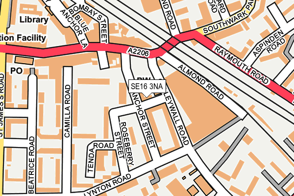
SE16 3NA is located in the South Bermondsey electoral ward, within the London borough of Southwark and the English Parliamentary constituency of Bermondsey and Old Southwark. The Sub Integrated Care Board (ICB) Location is NHS South East London ICB - 72Q and the police force is Metropolitan Police. This postcode has been in use since December 2000.


GetTheData
Source: OS OpenMap – Local (Ordnance Survey)
Source: OS VectorMap District (Ordnance Survey)
Licence: Open Government Licence (requires attribution)
| Easting | 534713 |
| Northing | 178709 |
| Latitude | 51.491287 |
| Longitude | -0.060983 |
GetTheData
Source: Open Postcode Geo
Licence: Open Government Licence
| Country | England |
| Postcode District | SE16 |
| ➜ SE16 open data dashboard ➜ See where SE16 is on a map ➜ Where is Bermondsey? | |
GetTheData
Source: Land Registry Price Paid Data
Licence: Open Government Licence
Elevation or altitude of SE16 3NA as distance above sea level:
| Metres | Feet | |
|---|---|---|
| Elevation | 10m | 33ft |
Elevation is measured from the approximate centre of the postcode, to the nearest point on an OS contour line from OS Terrain 50, which has contour spacing of ten vertical metres.
➜ How high above sea level am I? Find the elevation of your current position using your device's GPS.
GetTheData
Source: Open Postcode Elevation
Licence: Open Government Licence
| Ward | South Bermondsey |
| Constituency | Bermondsey And Old Southwark |
GetTheData
Source: ONS Postcode Database
Licence: Open Government Licence
| January 2024 | Violence and sexual offences | On or near Strathnairn Street | 354m |
| January 2024 | Other theft | On or near Stubbs Drive | 361m |
| January 2024 | Vehicle crime | On or near Stubbs Drive | 361m |
| ➜ Get more crime data in our Crime section | |||
GetTheData
Source: data.police.uk
Licence: Open Government Licence
| Anchor Street (Galleywall Road) | Bermondsey | 41m |
| Anchor Street (Southwark Park Road) | Bermondsey | 102m |
| Lynton Road (Se16) (Galleywall Road) | Bermondsey | 110m |
| Lynton Road (Se16) | Bermondsey | 147m |
| Raymouth Road (Southwark Park Road) | Bermondsey | 212m |
| Bermondsey Underground Station | Bermondsey | 766m |
| Canada Water Underground Station | Canada Water | 1,077m |
| South Bermondsey Station | 0.6km |
| Surrey Quays Station | 1km |
| Canada Water Station | 1.1km |
GetTheData
Source: NaPTAN
Licence: Open Government Licence
GetTheData
Source: ONS Postcode Database
Licence: Open Government Licence


➜ Get more ratings from the Food Standards Agency
GetTheData
Source: Food Standards Agency
Licence: FSA terms & conditions
| Last Collection | |||
|---|---|---|---|
| Location | Mon-Fri | Sat | Distance |
| Southwark Park Road | 17:30 | 12:00 | 92m |
| Galleywall Road | 17:30 | 12:00 | 143m |
| Post Office | 17:30 | 12:00 | 282m |
GetTheData
Source: Dracos
Licence: Creative Commons Attribution-ShareAlike
| Facility | Distance |
|---|---|
| The City Of London Academy (Southwark) Lynton Road, London Sports Hall, Artificial Grass Pitch, Health and Fitness Gym, Studio, Outdoor Tennis Courts | 345m |
| Puregym (London Bermondsey) 100 Drummond Road, Greater London , London Health and Fitness Gym, Studio | 346m |
| Muscle Factory Gym (Closed) Southwark Park Road, London Health and Fitness Gym | 354m |
GetTheData
Source: Active Places
Licence: Open Government Licence
| School | Phase of Education | Distance |
|---|---|---|
| Galleywall Primary School Galleywall Primary, Galleywall Road, London, SE16 3PB | Primary | 192m |
| Southwark Park Primary School 383 Southwark Park Road, Bermondsey, Southwark, London, SE16 2JH | Primary | 378m |
| City of London Academy (Southwark) 240 Lynton Road, London, SE1 5LA | Secondary | 427m |
GetTheData
Source: Edubase
Licence: Open Government Licence
| Risk of SE16 3NA flooding from rivers and sea | Very Low |
| ➜ SE16 3NA flood map | |
GetTheData
Source: Open Flood Risk by Postcode
Licence: Open Government Licence
The below table lists the International Territorial Level (ITL) codes (formerly Nomenclature of Territorial Units for Statistics (NUTS) codes) and Local Administrative Units (LAU) codes for SE16 3NA:
| ITL 1 Code | Name |
|---|---|
| TLI | London |
| ITL 2 Code | Name |
| TLI4 | Inner London - East |
| ITL 3 Code | Name |
| TLI44 | Lewisham and Southwark |
| LAU 1 Code | Name |
| E09000028 | Southwark |
GetTheData
Source: ONS Postcode Directory
Licence: Open Government Licence
The below table lists the Census Output Area (OA), Lower Layer Super Output Area (LSOA), and Middle Layer Super Output Area (MSOA) for SE16 3NA:
| Code | Name | |
|---|---|---|
| OA | E00020370 | |
| LSOA | E01004042 | Southwark 010D |
| MSOA | E02000816 | Southwark 010 |
GetTheData
Source: ONS Postcode Directory
Licence: Open Government Licence
| SE16 3LT | Anchor Street | 63m |
| SE16 3NU | Manor Estate | 64m |
| SE16 3NX | Manor Estate | 64m |
| SE16 3LX | Anchor Street | 82m |
| SE16 3NZ | Manor Estate | 99m |
| SE16 3LU | Roseberry Street | 112m |
| SE16 3PB | Galleywall Road | 113m |
| SE16 3NT | Manor Estate | 114m |
| SE16 3TP | Southwark Park Road | 120m |
| SE16 3NY | Ambrose Street | 137m |
GetTheData
Source: Open Postcode Geo; Land Registry Price Paid Data
Licence: Open Government Licence