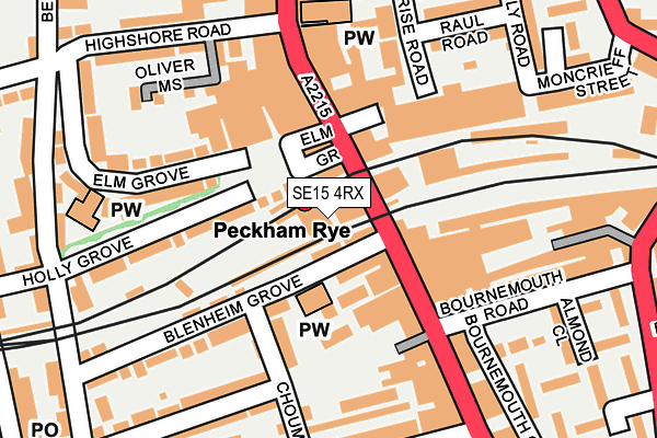
SE15 4RX lies on Station Way in London. SE15 4RX is located in the Rye Lane electoral ward, within the London borough of Southwark and the English Parliamentary constituency of Camberwell and Peckham. The Sub Integrated Care Board (ICB) Location is NHS South East London ICB - 72Q and the police force is Metropolitan Police. This postcode has been in use since January 1980.


GetTheData
Source: OS OpenMap – Local (Ordnance Survey)
Source: OS VectorMap District (Ordnance Survey)
Licence: Open Government Licence (requires attribution)
| Easting | 534204 |
| Northing | 176324 |
| Latitude | 51.469975 |
| Longitude | -0.069215 |
GetTheData
Source: Open Postcode Geo
Licence: Open Government Licence
| Street | Station Way |
| Town/City | London |
| Country | England |
| Postcode District | SE15 |
| ➜ SE15 open data dashboard ➜ See where SE15 is on a map ➜ Where is London? | |
GetTheData
Source: Land Registry Price Paid Data
Licence: Open Government Licence
Elevation or altitude of SE15 4RX as distance above sea level:
| Metres | Feet | |
|---|---|---|
| Elevation | 10m | 33ft |
Elevation is measured from the approximate centre of the postcode, to the nearest point on an OS contour line from OS Terrain 50, which has contour spacing of ten vertical metres.
➜ How high above sea level am I? Find the elevation of your current position using your device's GPS.
GetTheData
Source: Open Postcode Elevation
Licence: Open Government Licence
| Ward | Rye Lane |
| Constituency | Camberwell And Peckham |
GetTheData
Source: ONS Postcode Database
Licence: Open Government Licence
| January 2024 | Vehicle crime | On or near Parking Area | 140m |
| January 2024 | Violence and sexual offences | On or near Parking Area | 140m |
| January 2024 | Burglary | On or near Choumert Road | 358m |
| ➜ Get more crime data in our Crime section | |||
GetTheData
Source: data.police.uk
Licence: Open Government Licence
| Peckham Rye Station | Peckham | 51m |
| Blenheim Grove | Peckham | 52m |
| Peckham Rye Station | Peckham | 112m |
| The Aylesham Centre (Rye Lane) | Peckham | 165m |
| Chadwick Road | Peckham | 175m |
| Peckham Rye Station | 0km |
| Queens Road Peckham Station | 0.9km |
| Nunhead Station | 1.2km |
GetTheData
Source: NaPTAN
Licence: Open Government Licence
GetTheData
Source: ONS Postcode Database
Licence: Open Government Licence


➜ Get more ratings from the Food Standards Agency
GetTheData
Source: Food Standards Agency
Licence: FSA terms & conditions
| Last Collection | |||
|---|---|---|---|
| Location | Mon-Fri | Sat | Distance |
| Bournemouth Road | 17:30 | 12:00 | 161m |
| Post Office S E 1 5 5 A U | 17:30 | 12:00 | 220m |
| Hanover Park | 17:30 | 12:00 | 243m |
GetTheData
Source: Dracos
Licence: Creative Commons Attribution-ShareAlike
| Facility | Distance |
|---|---|
| The Gym Group (London Peckham Rye) Rye Lane, London Health and Fitness Gym | 112m |
| Highshore School (Closed) Bellenden Road, Peckham, London Sports Hall | 341m |
| Anytime Fitness (Peckham) Rye Lane, London Health and Fitness Gym | 360m |
GetTheData
Source: Active Places
Licence: Open Government Licence
| School | Phase of Education | Distance |
|---|---|---|
| Cherry Garden School 41 Bellenden Road, London, SE15 5BB | Not applicable | 327m |
| Harris Academy Peckham 112 Peckham Road, London, SE15 5DZ | Secondary | 460m |
| St Mary Magdalene Church of England Primary School 48 Brayards Road, London, SE15 3RA | Primary | 466m |
GetTheData
Source: Edubase
Licence: Open Government Licence
The below table lists the International Territorial Level (ITL) codes (formerly Nomenclature of Territorial Units for Statistics (NUTS) codes) and Local Administrative Units (LAU) codes for SE15 4RX:
| ITL 1 Code | Name |
|---|---|
| TLI | London |
| ITL 2 Code | Name |
| TLI4 | Inner London - East |
| ITL 3 Code | Name |
| TLI44 | Lewisham and Southwark |
| LAU 1 Code | Name |
| E09000028 | Southwark |
GetTheData
Source: ONS Postcode Directory
Licence: Open Government Licence
The below table lists the Census Output Area (OA), Lower Layer Super Output Area (LSOA), and Middle Layer Super Output Area (MSOA) for SE15 4RX:
| Code | Name | |
|---|---|---|
| OA | E00020457 | |
| LSOA | E01004063 | Southwark 025C |
| MSOA | E02000831 | Southwark 025 |
GetTheData
Source: ONS Postcode Directory
Licence: Open Government Licence
| SE15 4RY | Rye Lane | 26m |
| SE15 5DQ | Rye Lane | 48m |
| SE15 4ST | Rye Lane | 68m |
| SE15 4QW | Blenheim Grove | 69m |
| SE15 4QL | Blenheim Grove | 105m |
| SE15 4QS | Blenheim Grove | 121m |
| SE15 4RB | Choumert Grove | 128m |
| SE15 4RZ | Rye Lane | 130m |
| SE15 5BY | Rye Lane | 137m |
| SE15 5DB | Elm Grove | 141m |
GetTheData
Source: Open Postcode Geo; Land Registry Price Paid Data
Licence: Open Government Licence