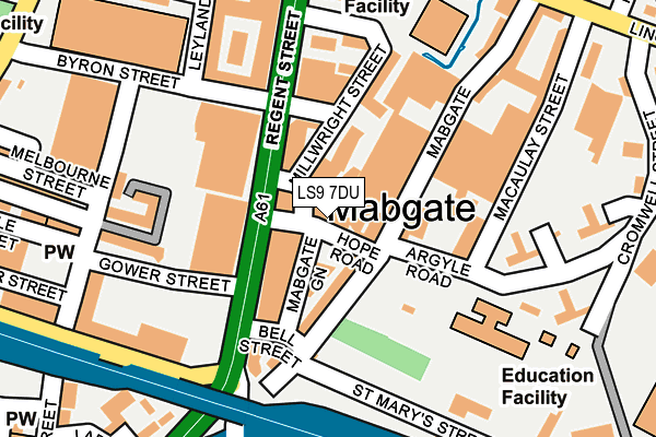
LS9 7DU is located in the Little London & Woodhouse electoral ward, within the metropolitan district of Leeds and the English Parliamentary constituency of Leeds Central. The Sub Integrated Care Board (ICB) Location is NHS West Yorkshire ICB - 15F and the police force is West Yorkshire. This postcode has been in use since January 1980.


GetTheData
Source: OS OpenMap – Local (Ordnance Survey)
Source: OS VectorMap District (Ordnance Survey)
Licence: Open Government Licence (requires attribution)
| Easting | 430897 |
| Northing | 433998 |
| Latitude | 53.801371 |
| Longitude | -1.532371 |
GetTheData
Source: Open Postcode Geo
Licence: Open Government Licence
| Country | England |
| Postcode District | LS9 |
➜ See where LS9 is on a map ➜ Where is Leeds? | |
GetTheData
Source: Land Registry Price Paid Data
Licence: Open Government Licence
Elevation or altitude of LS9 7DU as distance above sea level:
| Metres | Feet | |
|---|---|---|
| Elevation | 30m | 98ft |
Elevation is measured from the approximate centre of the postcode, to the nearest point on an OS contour line from OS Terrain 50, which has contour spacing of ten vertical metres.
➜ How high above sea level am I? Find the elevation of your current position using your device's GPS.
GetTheData
Source: Open Postcode Elevation
Licence: Open Government Licence
| Ward | Little London & Woodhouse |
| Constituency | Leeds Central |
GetTheData
Source: ONS Postcode Database
Licence: Open Government Licence
| Regent St Hope Road (Regent Street) | Mabgate | 74m |
| Byron Street Regent St (Byron Street) | Mabgate | 144m |
| Lincoln Green Rd Macauley Street (Lincoln Green Road) | Mabgate | 308m |
| North St Byron Street (North Street) | Mabgate | 331m |
| North St Byron Street (North Street) | Mabgate | 344m |
| Leeds Station | 1.2km |
| Burley Park Station | 3.2km |
| Headingley Station | 4.5km |
GetTheData
Source: NaPTAN
Licence: Open Government Licence
| Percentage of properties with Next Generation Access | 100.0% |
| Percentage of properties with Superfast Broadband | 100.0% |
| Percentage of properties with Ultrafast Broadband | 0.0% |
| Percentage of properties with Full Fibre Broadband | 0.0% |
Superfast Broadband is between 30Mbps and 300Mbps
Ultrafast Broadband is > 300Mbps
| Percentage of properties unable to receive 2Mbps | 0.0% |
| Percentage of properties unable to receive 5Mbps | 0.0% |
| Percentage of properties unable to receive 10Mbps | 0.0% |
| Percentage of properties unable to receive 30Mbps | 0.0% |
GetTheData
Source: Ofcom
Licence: Ofcom Terms of Use (requires attribution)
GetTheData
Source: ONS Postcode Database
Licence: Open Government Licence


➜ Get more ratings from the Food Standards Agency
GetTheData
Source: Food Standards Agency
Licence: FSA terms & conditions
| Last Collection | |||
|---|---|---|---|
| Location | Mon-Fri | Sat | Distance |
| Quarry Hill | 18:30 | 12:00 | 84m |
| Bridge Street | 233m | ||
| Playhouse Square | 18:30 | 12:15 | 335m |
GetTheData
Source: Dracos
Licence: Creative Commons Attribution-ShareAlike
| Risk of LS9 7DU flooding from rivers and sea | High |
| ➜ LS9 7DU flood map | |
GetTheData
Source: Open Flood Risk by Postcode
Licence: Open Government Licence
The below table lists the International Territorial Level (ITL) codes (formerly Nomenclature of Territorial Units for Statistics (NUTS) codes) and Local Administrative Units (LAU) codes for LS9 7DU:
| ITL 1 Code | Name |
|---|---|
| TLE | Yorkshire and The Humber |
| ITL 2 Code | Name |
| TLE4 | West Yorkshire |
| ITL 3 Code | Name |
| TLE42 | Leeds |
| LAU 1 Code | Name |
| E08000035 | Leeds |
GetTheData
Source: ONS Postcode Directory
Licence: Open Government Licence
The below table lists the Census Output Area (OA), Lower Layer Super Output Area (LSOA), and Middle Layer Super Output Area (MSOA) for LS9 7DU:
| Code | Name | |
|---|---|---|
| OA | E00170048 | |
| LSOA | E01033031 | Leeds 064E |
| MSOA | E02002393 | Leeds 064 |
GetTheData
Source: ONS Postcode Directory
Licence: Open Government Licence
| LS2 7QA | Millwright Street | 63m |
| LS9 7DE | Mabgate | 94m |
| LS9 7DB | Mabgate | 102m |
| LS2 7NA | Byron Street | 124m |
| LS2 7QP | Millwright Street | 147m |
| LS2 7JP | Regent Street | 157m |
| LS2 7JQ | Regent Street | 157m |
| LS2 7QQ | Millwright Street | 165m |
| LS9 7DR | Mabgate | 169m |
| LS2 7JS | Leylands Road | 187m |
GetTheData
Source: Open Postcode Geo; Land Registry Price Paid Data
Licence: Open Government Licence