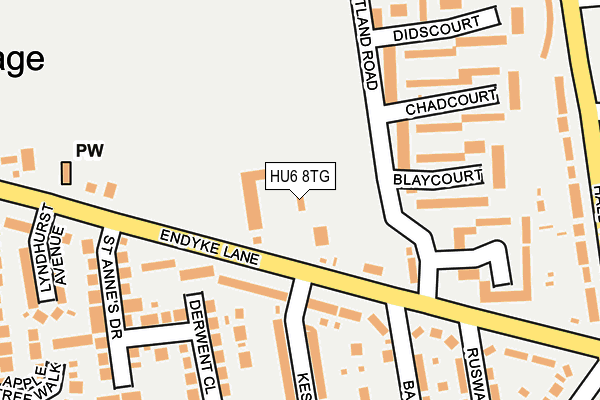
HU6 8TG lies on Endike Lane in Hull. HU6 8TG is located in the Cottingham South electoral ward, within the unitary authority of East Riding of Yorkshire and the English Parliamentary constituency of Haltemprice and Howden. The Sub Integrated Care Board (ICB) Location is NHS Humber and North Yorkshire ICB - 02Y and the police force is Humberside. This postcode has been in use since January 1980.


GetTheData
Source: OS OpenMap – Local (Ordnance Survey)
Source: OS VectorMap District (Ordnance Survey)
Licence: Open Government Licence (requires attribution)
| Easting | 506101 |
| Northing | 432760 |
| Latitude | 53.780366 |
| Longitude | -0.391290 |
GetTheData
Source: Open Postcode Geo
Licence: Open Government Licence
| Street | Endike Lane |
| Town/City | Hull |
| Country | England |
| Postcode District | HU6 |
| ➜ HU6 open data dashboard ➜ See where HU6 is on a map ➜ Where is Kingston upon Hull? | |
GetTheData
Source: Land Registry Price Paid Data
Licence: Open Government Licence
Elevation or altitude of HU6 8TG as distance above sea level:
| Metres | Feet | |
|---|---|---|
| Elevation | 10m | 33ft |
Elevation is measured from the approximate centre of the postcode, to the nearest point on an OS contour line from OS Terrain 50, which has contour spacing of ten vertical metres.
➜ How high above sea level am I? Find the elevation of your current position using your device's GPS.
GetTheData
Source: Open Postcode Elevation
Licence: Open Government Licence
| Ward | Cottingham South |
| Constituency | Haltemprice And Howden |
GetTheData
Source: ONS Postcode Database
Licence: Open Government Licence
POPLAR HOUSE, ENDIKE LANE, HULL, HU6 8TG 2006 2 FEB £50,000 |
ENDIKE FILLING STATION, ENDIKE LANE, HULL, HU6 8TG 2003 24 APR £110,000 |
➜ Kingston upon Hull house prices
GetTheData
Source: HM Land Registry Price Paid Data
Licence: Contains HM Land Registry data © Crown copyright and database right 2024. This data is licensed under the Open Government Licence v3.0.
| July 2023 | Bicycle theft | On or near Merchant Way | 481m |
| June 2023 | Burglary | On or near Merchant Way | 481m |
| April 2023 | Public order | On or near Merchant Way | 481m |
| ➜ Get more crime data in our Crime section | |||
GetTheData
Source: data.police.uk
Licence: Open Government Licence
| Cottingham Endyke Lane (Endyke Lane) | Cottingham | 104m |
| Cottingham Endyke Lane (Endyke Lane) | Cottingham | 119m |
| Ancourt (Endike Lane) | Inglemire | 178m |
| Ruswarp Grove (Endike Lane) | Inglemire | 246m |
| Glencourt (Hall Road) | Orchard Park | 302m |
| Cottingham Station | 1km |
| Hull Station | 5km |
GetTheData
Source: NaPTAN
Licence: Open Government Licence
GetTheData
Source: ONS Postcode Database
Licence: Open Government Licence


➜ Get more ratings from the Food Standards Agency
GetTheData
Source: Food Standards Agency
Licence: FSA terms & conditions
| Last Collection | |||
|---|---|---|---|
| Location | Mon-Fri | Sat | Distance |
| Greenwood Avenue Hull | 16:45 | 11:45 | 396m |
| Courtland Road Hull | 16:45 | 11:30 | 406m |
| Lytham Drive | 17:30 | 10:45 | 491m |
GetTheData
Source: Dracos
Licence: Creative Commons Attribution-ShareAlike
| Facility | Distance |
|---|---|
| Courtland Road Playing Fields Courtland Road, Hull Grass Pitches | 388m |
| St Anthony's Voluntary Catholic Academy Dane Park Road, Hull Grass Pitches | 477m |
| The Parks Academy Courtway Road, Hull Grass Pitches | 523m |
GetTheData
Source: Active Places
Licence: Open Government Licence
| School | Phase of Education | Distance |
|---|---|---|
| St Anthony's Voluntary Catholic Academy Dane Park Road, Hull, HU6 9AA | Primary | 474m |
| The Parks Primary Academy Courtway Road, Hull, HU6 9TA | Primary | 574m |
| Croxby Primary School Bricknell Avenue, Hull, HU5 4TN | Primary | 1km |
GetTheData
Source: Edubase
Licence: Open Government Licence
| Risk of HU6 8TG flooding from rivers and sea | Low |
| ➜ HU6 8TG flood map | |
GetTheData
Source: Open Flood Risk by Postcode
Licence: Open Government Licence
The below table lists the International Territorial Level (ITL) codes (formerly Nomenclature of Territorial Units for Statistics (NUTS) codes) and Local Administrative Units (LAU) codes for HU6 8TG:
| ITL 1 Code | Name |
|---|---|
| TLE | Yorkshire and The Humber |
| ITL 2 Code | Name |
| TLE1 | East Yorkshire and Northern Lincolnshire |
| ITL 3 Code | Name |
| TLE12 | East Riding of Yorkshire |
| LAU 1 Code | Name |
| E06000011 | East Riding of Yorkshire |
GetTheData
Source: ONS Postcode Directory
Licence: Open Government Licence
The below table lists the Census Output Area (OA), Lower Layer Super Output Area (LSOA), and Middle Layer Super Output Area (MSOA) for HU6 8TG:
| Code | Name | |
|---|---|---|
| OA | E00065392 | |
| LSOA | E01012959 | East Riding of Yorkshire 023C |
| MSOA | E02002706 | East Riding of Yorkshire 023 |
GetTheData
Source: ONS Postcode Directory
Licence: Open Government Licence
| HU6 8TE | Endike Lane | 101m |
| HU6 8TA | Endike Lane | 119m |
| HU6 8AZ | Blaycourt | 158m |
| HU6 8TB | Keswick Gardens | 185m |
| HU6 8TH | Endike Lane | 188m |
| HU6 8BA | Chadcourt | 189m |
| HU6 8AY | Ancourt | 191m |
| HU16 4QR | Derwent Close | 200m |
| HU6 8SZ | Bainton Grove | 224m |
| HU6 8BB | Didscourt | 228m |
GetTheData
Source: Open Postcode Geo; Land Registry Price Paid Data
Licence: Open Government Licence