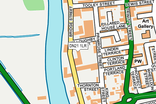
DN21 1LR is located in the Gainsborough South-West electoral ward, within the local authority district of West Lindsey and the English Parliamentary constituency of Gainsborough. The Sub Integrated Care Board (ICB) Location is NHS Lincolnshire ICB - 71E and the police force is Lincolnshire. This postcode has been in use since January 1980.


GetTheData
Source: OS OpenMap – Local (Ordnance Survey)
Source: OS VectorMap District (Ordnance Survey)
Licence: Open Government Licence (requires attribution)
| Easting | 481513 |
| Northing | 389317 |
| Latitude | 53.394403 |
| Longitude | -0.775663 |
GetTheData
Source: Open Postcode Geo
Licence: Open Government Licence
| Country | England |
| Postcode District | DN21 |
➜ See where DN21 is on a map ➜ Where is Gainsborough? | |
GetTheData
Source: Land Registry Price Paid Data
Licence: Open Government Licence
Elevation or altitude of DN21 1LR as distance above sea level:
| Metres | Feet | |
|---|---|---|
| Elevation | 10m | 33ft |
Elevation is measured from the approximate centre of the postcode, to the nearest point on an OS contour line from OS Terrain 50, which has contour spacing of ten vertical metres.
➜ How high above sea level am I? Find the elevation of your current position using your device's GPS.
GetTheData
Source: Open Postcode Elevation
Licence: Open Government Licence
| Ward | Gainsborough South-west |
| Constituency | Gainsborough |
GetTheData
Source: ONS Postcode Database
Licence: Open Government Licence
| Portland Terrace (Trinity Street) | Gainsborough | 200m |
| King Street (Bridge Street) | Gainsborough | 218m |
| Trinity Arts Centre (Trinity Street) | Gainsborough | 223m |
| King Street (Bridge Street) | Gainsborough | 244m |
| St Johns Church (Ashcroft Road) | Gainsborough | 309m |
| Gainsborough Central Station | 0.7km |
| Gainsborough Lea Road Station | 1km |
GetTheData
Source: NaPTAN
Licence: Open Government Licence
GetTheData
Source: ONS Postcode Database
Licence: Open Government Licence


➜ Get more ratings from the Food Standards Agency
GetTheData
Source: Food Standards Agency
Licence: FSA terms & conditions
| Last Collection | |||
|---|---|---|---|
| Location | Mon-Fri | Sat | Distance |
| Trinity St P.o. | 17:15 | 11:45 | 199m |
| Waterworks Street | 16:45 | 11:30 | 364m |
| Gainsborough Delivery Office | 17:30 | 12:30 | 538m |
GetTheData
Source: Dracos
Licence: Creative Commons Attribution-ShareAlike
| Risk of DN21 1LR flooding from rivers and sea | Low |
| ➜ DN21 1LR flood map | |
GetTheData
Source: Open Flood Risk by Postcode
Licence: Open Government Licence
The below table lists the International Territorial Level (ITL) codes (formerly Nomenclature of Territorial Units for Statistics (NUTS) codes) and Local Administrative Units (LAU) codes for DN21 1LR:
| ITL 1 Code | Name |
|---|---|
| TLF | East Midlands (England) |
| ITL 2 Code | Name |
| TLF3 | Lincolnshire |
| ITL 3 Code | Name |
| TLF30 | Lincolnshire CC |
| LAU 1 Code | Name |
| E07000142 | West Lindsey |
GetTheData
Source: ONS Postcode Directory
Licence: Open Government Licence
The below table lists the Census Output Area (OA), Lower Layer Super Output Area (LSOA), and Middle Layer Super Output Area (MSOA) for DN21 1LR:
| Code | Name | |
|---|---|---|
| OA | E00134031 | |
| LSOA | E01026383 | West Lindsey 004E |
| MSOA | E02005495 | West Lindsey 004 |
GetTheData
Source: ONS Postcode Directory
Licence: Open Government Licence
| DN21 1LP | Bridge Street | 48m |
| DN21 1JA | Bridge Street | 101m |
| DN21 1JL | Clinton Terrace | 132m |
| DN21 1JQ | Linden Terrace | 136m |
| DN21 1HX | Pillard House Lane | 140m |
| DN21 1JR | Portland Terrace | 140m |
| DN21 1LE | King Street | 163m |
| DN21 1HZ | Wall Street | 186m |
| DN21 1JN | Trinity Street | 188m |
| DN21 1LN | Thorndike Mews | 191m |
GetTheData
Source: Open Postcode Geo; Land Registry Price Paid Data
Licence: Open Government Licence