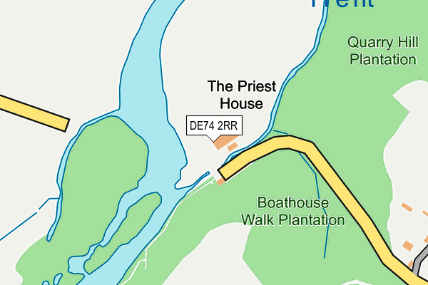
DE74 2RR lies on Kings Mills in Castle Donington, Derby. DE74 2RR is located in the Castle Donington Park electoral ward, within the local authority district of North West Leicestershire and the English Parliamentary constituency of North West Leicestershire. The Sub Integrated Care Board (ICB) Location is NHS Leicester, Leicestershire and Rutland ICB - 04V and the police force is Leicestershire. This postcode has been in use since August 1992.


GetTheData
Source: OS OpenMap – Local (Ordnance Survey)
Source: OS VectorMap District (Ordnance Survey)
Licence: Open Government Licence (requires attribution)
| Easting | 441752 |
| Northing | 327475 |
| Latitude | 52.843191 |
| Longitude | -1.381556 |
GetTheData
Source: Open Postcode Geo
Licence: Open Government Licence
| Street | Kings Mills |
| Locality | Castle Donington |
| Town/City | Derby |
| Country | England |
| Postcode District | DE74 |
| ➜ DE74 open data dashboard ➜ See where DE74 is on a map | |
GetTheData
Source: Land Registry Price Paid Data
Licence: Open Government Licence
Elevation or altitude of DE74 2RR as distance above sea level:
| Metres | Feet | |
|---|---|---|
| Elevation | 40m | 131ft |
Elevation is measured from the approximate centre of the postcode, to the nearest point on an OS contour line from OS Terrain 50, which has contour spacing of ten vertical metres.
➜ How high above sea level am I? Find the elevation of your current position using your device's GPS.
GetTheData
Source: Open Postcode Elevation
Licence: Open Government Licence
| Ward | Castle Donington Park |
| Constituency | North West Leicestershire |
GetTheData
Source: ONS Postcode Database
Licence: Open Government Licence
| June 2022 | Other theft | On or near Parking Area | 499m |
| June 2022 | Other theft | On or near Parking Area | 499m |
| June 2022 | Theft from the person | On or near Parking Area | 499m |
| ➜ Get more crime data in our Crime section | |||
GetTheData
Source: data.police.uk
Licence: Open Government Licence
| King's Mills Lane (Main Street) | Weston-on-trent | 1,458m |
| The Green (Main Street) | Weston-on-trent | 1,463m |
| The Green (Main Street) | Weston-on-trent | 1,467m |
| King's Mills Lane (Main Street) | Weston-on-trent | 1,468m |
| Weston Road | Weston-on-trent | 1,485m |
GetTheData
Source: NaPTAN
Licence: Open Government Licence
GetTheData
Source: ONS Postcode Database
Licence: Open Government Licence


➜ Get more ratings from the Food Standards Agency
GetTheData
Source: Food Standards Agency
Licence: FSA terms & conditions
| Last Collection | |||
|---|---|---|---|
| Location | Mon-Fri | Sat | Distance |
| Weston On Trent | 17:15 | 10:30 | 1,545m |
| Aston On Trent | 17:00 | 10:30 | 1,797m |
| Ashton On Trent | 17:15 | 10:30 | 2,012m |
GetTheData
Source: Dracos
Licence: Creative Commons Attribution-ShareAlike
| Facility | Distance |
|---|---|
| Weston-on-trent C Of E Primary School Forrester Avenue, Weston-on-trent, Derby Grass Pitches | 1.4km |
| Aston Hall Hospital (Closed) Shardlow Road, Aston-upon-trent Grass Pitches | 1.5km |
| The Recreation Centre (Aston-on-trent) Shardlow Road, Aston-on-trent, Derby Grass Pitches, Sports Hall | 1.8km |
GetTheData
Source: Active Places
Licence: Open Government Licence
| School | Phase of Education | Distance |
|---|---|---|
| Weston-on-Trent CofE (VA) Primary School Forrester Avenue, Weston-on-Trent, Derby, DE72 2HX | Primary | 1.3km |
| Foxbridge Primary School Welsted Road, Castle Donington, DE74 2SN | Primary | 1.7km |
| Aston-on-Trent Primary School Long Croft, Aston-on-Trent, Derby, DE72 2UH | Primary | 2.3km |
GetTheData
Source: Edubase
Licence: Open Government Licence
| Risk of DE74 2RR flooding from rivers and sea | Medium |
| ➜ DE74 2RR flood map | |
GetTheData
Source: Open Flood Risk by Postcode
Licence: Open Government Licence
The below table lists the International Territorial Level (ITL) codes (formerly Nomenclature of Territorial Units for Statistics (NUTS) codes) and Local Administrative Units (LAU) codes for DE74 2RR:
| ITL 1 Code | Name |
|---|---|
| TLF | East Midlands (England) |
| ITL 2 Code | Name |
| TLF2 | Leicestershire, Rutland and Northamptonshire |
| ITL 3 Code | Name |
| TLF22 | Leicestershire CC and Rutland |
| LAU 1 Code | Name |
| E07000134 | North West Leicestershire |
GetTheData
Source: ONS Postcode Directory
Licence: Open Government Licence
The below table lists the Census Output Area (OA), Lower Layer Super Output Area (LSOA), and Middle Layer Super Output Area (MSOA) for DE74 2RR:
| Code | Name | |
|---|---|---|
| OA | E00131560 | |
| LSOA | E01025926 | North West Leicestershire 001C |
| MSOA | E02005397 | North West Leicestershire 001 |
GetTheData
Source: ONS Postcode Directory
Licence: Open Government Licence
| DE74 2GR | Home Farm Courtyard | 459m |
| DE74 2RS | Park Lane | 479m |
| DE72 2BT | Trent Lane | 1294m |
| DE72 2BQ | Kings Mill Lane | 1333m |
| DE72 2HX | Forrester Avenue | 1335m |
| DE72 2BZ | Old Gate Avenue | 1402m |
| DE72 2BP | The Avenue | 1404m |
| DE72 2DQ | The Pastures | 1410m |
| DE72 2BH | Weston Road | 1463m |
| DE72 2DJ | Weston Court | 1481m |
GetTheData
Source: Open Postcode Geo; Land Registry Price Paid Data
Licence: Open Government Licence