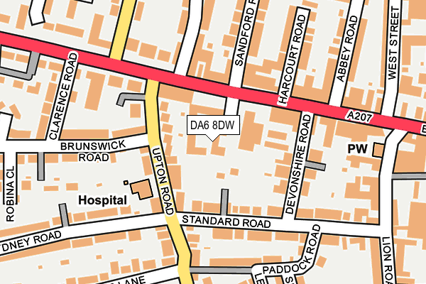
DA6 8DW is located in the Crook Log electoral ward, within the London borough of Bexley and the English Parliamentary constituency of Bexleyheath and Crayford. The Sub Integrated Care Board (ICB) Location is NHS South East London ICB - 72Q and the police force is Metropolitan Police. This postcode has been in use since February 1990.


GetTheData
Source: OS OpenMap – Local (Ordnance Survey)
Source: OS VectorMap District (Ordnance Survey)
Licence: Open Government Licence (requires attribution)
| Easting | 548255 |
| Northing | 175342 |
| Latitude | 51.457648 |
| Longitude | 0.132526 |
GetTheData
Source: Open Postcode Geo
Licence: Open Government Licence
| Country | England |
| Postcode District | DA6 |
| ➜ DA6 open data dashboard ➜ See where DA6 is on a map ➜ Where is London? | |
GetTheData
Source: Land Registry Price Paid Data
Licence: Open Government Licence
Elevation or altitude of DA6 8DW as distance above sea level:
| Metres | Feet | |
|---|---|---|
| Elevation | 50m | 164ft |
Elevation is measured from the approximate centre of the postcode, to the nearest point on an OS contour line from OS Terrain 50, which has contour spacing of ten vertical metres.
➜ How high above sea level am I? Find the elevation of your current position using your device's GPS.
GetTheData
Source: Open Postcode Elevation
Licence: Open Government Licence
| Ward | Crook Log |
| Constituency | Bexleyheath And Crayford |
GetTheData
Source: ONS Postcode Database
Licence: Open Government Licence
| January 2024 | Violence and sexual offences | On or near Robina Close | 291m |
| January 2024 | Burglary | On or near Trinity Place | 448m |
| January 2024 | Other theft | On or near Trinity Place | 448m |
| ➜ Get more crime data in our Crime section | |||
GetTheData
Source: data.police.uk
Licence: Open Government Licence
| Upton Road Broadway (Broadway) | Bexleyheath | 73m |
| Upton Road Broadway (Broadway) | Bexleyheath | 82m |
| Lion Road | Bexleyheath | 191m |
| Avenue Road Crook Log (Avenue Road) | East Wickham | 196m |
| Crook Log Dallin Road (Crook Log) | East Wickham | 255m |
| Bexleyheath Station | 0.7km |
| Barnehurst Station | 2.1km |
| Bexley Station | 2.2km |
GetTheData
Source: NaPTAN
Licence: Open Government Licence
| Percentage of properties with Next Generation Access | 0.0% |
| Percentage of properties with Superfast Broadband | 0.0% |
| Percentage of properties with Ultrafast Broadband | 0.0% |
| Percentage of properties with Full Fibre Broadband | 0.0% |
Superfast Broadband is between 30Mbps and 300Mbps
Ultrafast Broadband is > 300Mbps
| Percentage of properties unable to receive 2Mbps | 0.0% |
| Percentage of properties unable to receive 5Mbps | 0.0% |
| Percentage of properties unable to receive 10Mbps | 0.0% |
| Percentage of properties unable to receive 30Mbps | 100.0% |
GetTheData
Source: Ofcom
Licence: Ofcom Terms of Use (requires attribution)
GetTheData
Source: ONS Postcode Database
Licence: Open Government Licence


➜ Get more ratings from the Food Standards Agency
GetTheData
Source: Food Standards Agency
Licence: FSA terms & conditions
| Last Collection | |||
|---|---|---|---|
| Location | Mon-Fri | Sat | Distance |
| Broadway | 18:00 | 11:15 | 314m |
| Ethronvi Road | 18:00 | 11:15 | 318m |
| Lion Road | 18:00 | 12:00 | 478m |
GetTheData
Source: Dracos
Licence: Creative Commons Attribution-ShareAlike
| Facility | Distance |
|---|---|
| Better Gym (Bexleyheath) Broadway, Bexleyheath Health and Fitness Gym | 49m |
| Changes Womens Health Club (Closed) Devonshire Road, Bexleyheath Health and Fitness Gym, Studio | 106m |
| Splashworld Swimming Centre (Closed) Crook Log, Bexleyheath Studio, Swimming Pool | 512m |
GetTheData
Source: Active Places
Licence: Open Government Licence
| School | Phase of Education | Distance |
|---|---|---|
| Crook Log Primary School Crook Log, Bexleyheath, DA6 8EQ | Primary | 418m |
| Upland Primary School Church Road, Bexleyheath, DA7 4DG | Primary | 541m |
| Aspire Academy South Gipsy Road, Welling, DA16 1JB | Not applicable | 794m |
GetTheData
Source: Edubase
Licence: Open Government Licence
The below table lists the International Territorial Level (ITL) codes (formerly Nomenclature of Territorial Units for Statistics (NUTS) codes) and Local Administrative Units (LAU) codes for DA6 8DW:
| ITL 1 Code | Name |
|---|---|
| TLI | London |
| ITL 2 Code | Name |
| TLI5 | Outer London - East and North East |
| ITL 3 Code | Name |
| TLI51 | Bexley and Greenwich |
| LAU 1 Code | Name |
| E09000004 | Bexley |
GetTheData
Source: ONS Postcode Directory
Licence: Open Government Licence
The below table lists the Census Output Area (OA), Lower Layer Super Output Area (LSOA), and Middle Layer Super Output Area (MSOA) for DA6 8DW:
| Code | Name | |
|---|---|---|
| OA | E00001773 | |
| LSOA | E01000360 | Bexley 015A |
| MSOA | E02000079 | Bexley 015 |
GetTheData
Source: ONS Postcode Directory
Licence: Open Government Licence
| DA6 8DT | Broadway | 49m |
| DA6 8LG | Upton Villas | 71m |
| DA6 8LQ | Upton Road | 83m |
| DA6 8AA | Broadway | 94m |
| DA6 8DR | Standard Road | 102m |
| DA6 8DS | Devonshire Road | 107m |
| DA7 4BY | Pickford Road | 112m |
| DA6 8AH | Broadway | 112m |
| DA6 8LF | Upton Road | 120m |
| DA6 8BW | Crook Log | 133m |
GetTheData
Source: Open Postcode Geo; Land Registry Price Paid Data
Licence: Open Government Licence