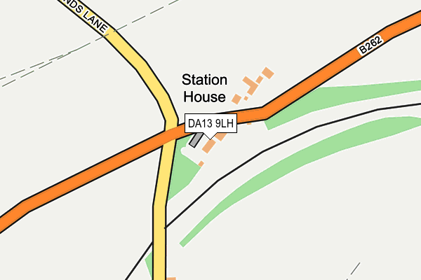
DA13 9LH lies on Station Road in Southfleet, Gravesend. DA13 9LH is located in the Longfield, New Barn & Southfleet electoral ward, within the local authority district of Dartford and the English Parliamentary constituency of Dartford. The Sub Integrated Care Board (ICB) Location is NHS Kent and Medway ICB - 91Q and the police force is Kent. This postcode has been in use since January 1980.


GetTheData
Source: OS OpenMap – Local (Ordnance Survey)
Source: OS VectorMap District (Ordnance Survey)
Licence: Open Government Licence (requires attribution)
| Easting | 561365 |
| Northing | 171939 |
| Latitude | 51.423493 |
| Longitude | 0.319517 |
GetTheData
Source: Open Postcode Geo
Licence: Open Government Licence
| Street | Station Road |
| Locality | Southfleet |
| Town/City | Gravesend |
| Country | England |
| Postcode District | DA13 |
| ➜ DA13 open data dashboard ➜ See where DA13 is on a map | |
GetTheData
Source: Land Registry Price Paid Data
Licence: Open Government Licence
Elevation or altitude of DA13 9LH as distance above sea level:
| Metres | Feet | |
|---|---|---|
| Elevation | 30m | 98ft |
Elevation is measured from the approximate centre of the postcode, to the nearest point on an OS contour line from OS Terrain 50, which has contour spacing of ten vertical metres.
➜ How high above sea level am I? Find the elevation of your current position using your device's GPS.
GetTheData
Source: Open Postcode Elevation
Licence: Open Government Licence
| Ward | Longfield, New Barn & Southfleet |
| Constituency | Dartford |
GetTheData
Source: ONS Postcode Database
Licence: Open Government Licence
| June 2022 | Violence and sexual offences | On or near Station Road | 116m |
| May 2022 | Anti-social behaviour | On or near Station Road | 116m |
| January 2022 | Violence and sexual offences | On or near Station Road | 116m |
| ➜ Get more crime data in our Crime section | |||
GetTheData
Source: data.police.uk
Licence: Open Government Licence
| Station Road | Southfleet | 25m |
| Station Road | Southfleet | 49m |
| Garden Centre (Station Road) | Northfleet | 494m |
| Garden Centre (Station Road) | Northfleet | 524m |
| The Ship (Red Street) | Southfleet | 855m |
| Ebbsfleet International Station | 2.2km |
| Northfleet Station | 2.5km |
| Swanscombe Station | 2.9km |
GetTheData
Source: NaPTAN
Licence: Open Government Licence
| Percentage of properties with Next Generation Access | 100.0% |
| Percentage of properties with Superfast Broadband | 0.0% |
| Percentage of properties with Ultrafast Broadband | 0.0% |
| Percentage of properties with Full Fibre Broadband | 0.0% |
Superfast Broadband is between 30Mbps and 300Mbps
Ultrafast Broadband is > 300Mbps
| Percentage of properties unable to receive 2Mbps | 0.0% |
| Percentage of properties unable to receive 5Mbps | 0.0% |
| Percentage of properties unable to receive 10Mbps | 0.0% |
| Percentage of properties unable to receive 30Mbps | 100.0% |
GetTheData
Source: Ofcom
Licence: Ofcom Terms of Use (requires attribution)
GetTheData
Source: ONS Postcode Database
Licence: Open Government Licence


➜ Get more ratings from the Food Standards Agency
GetTheData
Source: Food Standards Agency
Licence: FSA terms & conditions
| Last Collection | |||
|---|---|---|---|
| Location | Mon-Fri | Sat | Distance |
| Pepper Hill | 17:30 | 11:45 | 1,201m |
| Waterdales | 17:30 | 11:45 | 1,320m |
| Painters Ash Post Office | 17:30 | 12:00 | 1,520m |
GetTheData
Source: Dracos
Licence: Creative Commons Attribution-ShareAlike
| Facility | Distance |
|---|---|
| Southfleet Village Hall Dale Road, Southfleet Grass Pitches | 747m |
| Southfleet Cricket Club New Barn Road, Longfield Grass Pitches | 1.1km |
| Springhead Park School Springhead Parkway, Springhead Parkway, Northfleet, Gravesend Grass Pitches | 1.3km |
GetTheData
Source: Active Places
Licence: Open Government Licence
| School | Phase of Education | Distance |
|---|---|---|
| Sedley's Church of England Primary School Church Street, Southfleet, Gravesend, DA13 9NR | Primary | 811m |
| Springhead Park Primary School Springhead Parkway, Springhead Park, Northfleet, DA11 8BY | Primary | 1.3km |
| Painters Ash Primary School Masefield Road, Northfleet, Gravesend, DA11 8EL | Primary | 1.3km |
GetTheData
Source: Edubase
Licence: Open Government Licence
The below table lists the International Territorial Level (ITL) codes (formerly Nomenclature of Territorial Units for Statistics (NUTS) codes) and Local Administrative Units (LAU) codes for DA13 9LH:
| ITL 1 Code | Name |
|---|---|
| TLJ | South East (England) |
| ITL 2 Code | Name |
| TLJ4 | Kent |
| ITL 3 Code | Name |
| TLJ43 | Kent Thames Gateway |
| LAU 1 Code | Name |
| E07000107 | Dartford |
GetTheData
Source: ONS Postcode Directory
Licence: Open Government Licence
The below table lists the Census Output Area (OA), Lower Layer Super Output Area (LSOA), and Middle Layer Super Output Area (MSOA) for DA13 9LH:
| Code | Name | |
|---|---|---|
| OA | E00122654 | |
| LSOA | E01024157 | Dartford 013A |
| MSOA | E02005040 | Dartford 013 |
GetTheData
Source: ONS Postcode Directory
Licence: Open Government Licence
| DA13 9NX | Dale Road | 321m |
| DA13 9PA | Station Road | 633m |
| DA13 9LJ | Park Corner Road | 687m |
| DA13 9PB | Crayburne | 811m |
| DA13 9NN | Warren Road | 811m |
| DA13 9NW | Warren Cottages | 811m |
| DA13 9NR | Church Street | 814m |
| DA11 8AA | Watling Street | 843m |
| DA13 9QN | Red Street | 852m |
| DA13 9LL | New Cottages | 855m |
GetTheData
Source: Open Postcode Geo; Land Registry Price Paid Data
Licence: Open Government Licence