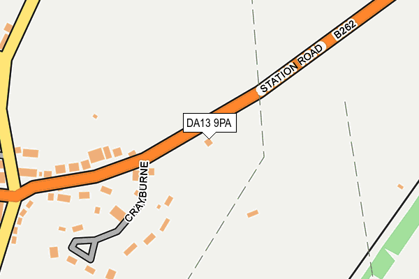
DA13 9PA lies on Station Road in Southfleet, Gravesend. DA13 9PA is located in the Longfield, New Barn & Southfleet electoral ward, within the local authority district of Dartford and the English Parliamentary constituency of Dartford. The Sub Integrated Care Board (ICB) Location is NHS Kent and Medway ICB - 91Q and the police force is Kent. This postcode has been in use since January 1980.


GetTheData
Source: OS OpenMap – Local (Ordnance Survey)
Source: OS VectorMap District (Ordnance Survey)
Licence: Open Government Licence (requires attribution)
| Easting | 560818 |
| Northing | 171620 |
| Latitude | 51.420782 |
| Longitude | 0.311511 |
GetTheData
Source: Open Postcode Geo
Licence: Open Government Licence
| Street | Station Road |
| Locality | Southfleet |
| Town/City | Gravesend |
| Country | England |
| Postcode District | DA13 |
➜ See where DA13 is on a map | |
GetTheData
Source: Land Registry Price Paid Data
Licence: Open Government Licence
Elevation or altitude of DA13 9PA as distance above sea level:
| Metres | Feet | |
|---|---|---|
| Elevation | 40m | 131ft |
Elevation is measured from the approximate centre of the postcode, to the nearest point on an OS contour line from OS Terrain 50, which has contour spacing of ten vertical metres.
➜ How high above sea level am I? Find the elevation of your current position using your device's GPS.
GetTheData
Source: Open Postcode Elevation
Licence: Open Government Licence
| Ward | Longfield, New Barn & Southfleet |
| Constituency | Dartford |
GetTheData
Source: ONS Postcode Database
Licence: Open Government Licence
| Colyer's Place (Station Road) | Betsham | 247m |
| Colyer's Place (Station Road) | Betsham | 278m |
| Station Road | Southfleet | 613m |
| Station Road | Southfleet | 652m |
| The Ship (Red Street) | Southfleet | 833m |
| Ebbsfleet International Station | 2.6km |
| Longfield Station | 2.8km |
| Northfleet Station | 2.9km |
GetTheData
Source: NaPTAN
Licence: Open Government Licence
| Percentage of properties with Next Generation Access | 100.0% |
| Percentage of properties with Superfast Broadband | 95.5% |
| Percentage of properties with Ultrafast Broadband | 0.0% |
| Percentage of properties with Full Fibre Broadband | 0.0% |
Superfast Broadband is between 30Mbps and 300Mbps
Ultrafast Broadband is > 300Mbps
| Median download speed | 19.9Mbps |
| Average download speed | 41.7Mbps |
| Maximum download speed | 80.00Mbps |
| Median upload speed | 6.8Mbps |
| Average upload speed | 9.8Mbps |
| Maximum upload speed | 20.00Mbps |
| Percentage of properties unable to receive 2Mbps | 0.0% |
| Percentage of properties unable to receive 5Mbps | 0.0% |
| Percentage of properties unable to receive 10Mbps | 0.0% |
| Percentage of properties unable to receive 30Mbps | 4.5% |
GetTheData
Source: Ofcom
Licence: Ofcom Terms of Use (requires attribution)
Estimated total energy consumption in DA13 9PA by fuel type, 2015.
| Consumption (kWh) | 360,873 |
|---|---|
| Meter count | 25 |
| Mean (kWh/meter) | 14,435 |
| Median (kWh/meter) | 11,938 |
| Consumption (kWh) | 66,264 |
|---|---|
| Meter count | 15 |
| Mean (kWh/meter) | 4,418 |
| Median (kWh/meter) | 2,953 |
GetTheData
Source: Postcode level gas estimates: 2015 (experimental)
Source: Postcode level electricity estimates: 2015 (experimental)
Licence: Open Government Licence
GetTheData
Source: ONS Postcode Database
Licence: Open Government Licence


➜ Get more ratings from the Food Standards Agency
GetTheData
Source: Food Standards Agency
Licence: FSA terms & conditions
| Last Collection | |||
|---|---|---|---|
| Location | Mon-Fri | Sat | Distance |
| The Thrift | 17:30 | 11:30 | 1,750m |
| Pepper Hill | 17:30 | 11:45 | 1,827m |
| Waterdales | 17:30 | 11:45 | 1,943m |
GetTheData
Source: Dracos
Licence: Creative Commons Attribution-ShareAlike
The below table lists the International Territorial Level (ITL) codes (formerly Nomenclature of Territorial Units for Statistics (NUTS) codes) and Local Administrative Units (LAU) codes for DA13 9PA:
| ITL 1 Code | Name |
|---|---|
| TLJ | South East (England) |
| ITL 2 Code | Name |
| TLJ4 | Kent |
| ITL 3 Code | Name |
| TLJ43 | Kent Thames Gateway |
| LAU 1 Code | Name |
| E07000107 | Dartford |
GetTheData
Source: ONS Postcode Directory
Licence: Open Government Licence
The below table lists the Census Output Area (OA), Lower Layer Super Output Area (LSOA), and Middle Layer Super Output Area (MSOA) for DA13 9PA:
| Code | Name | |
|---|---|---|
| OA | E00122654 | |
| LSOA | E01024157 | Dartford 013A |
| MSOA | E02005040 | Dartford 013 |
GetTheData
Source: ONS Postcode Directory
Licence: Open Government Licence
| DA13 9PB | Crayburne | 190m |
| DA13 9PJ | Yew Tree Cottages | 241m |
| DA13 9PL | Colyers Place | 262m |
| DA13 9LT | Orchard Lea | 297m |
| DA13 9LP | Ingress Terrace | 311m |
| DA13 9LN | Park Corner Road | 324m |
| DA13 9LL | New Cottages | 327m |
| DA13 9LW | North End Cottages | 330m |
| DA13 9LJ | Park Corner Road | 373m |
| DA13 9NU | Broomhills | 401m |
GetTheData
Source: Open Postcode Geo; Land Registry Price Paid Data
Licence: Open Government Licence