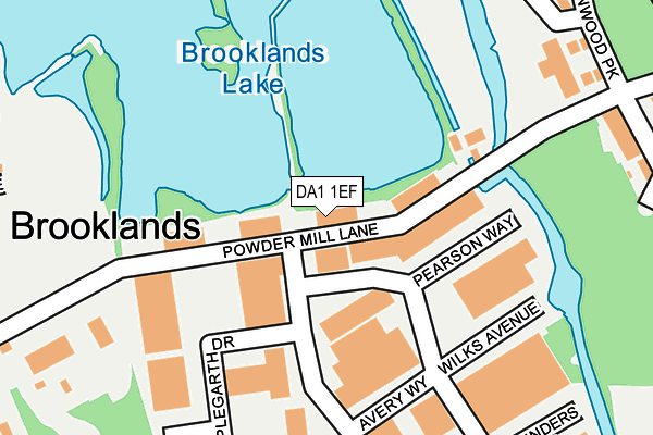
DA1 1EF is located in the Princes electoral ward, within the local authority district of Dartford and the English Parliamentary constituency of Dartford. The Sub Integrated Care Board (ICB) Location is NHS Kent and Medway ICB - 91Q and the police force is Kent. This postcode has been in use since July 1990.


GetTheData
Source: OS OpenMap – Local (Ordnance Survey)
Source: OS VectorMap District (Ordnance Survey)
Licence: Open Government Licence (requires attribution)
| Easting | 554571 |
| Northing | 172958 |
| Latitude | 51.434541 |
| Longitude | 0.222324 |
GetTheData
Source: Open Postcode Geo
Licence: Open Government Licence
| Country | England |
| Postcode District | DA1 |
| ➜ DA1 open data dashboard ➜ See where DA1 is on a map ➜ Where is Dartford? | |
GetTheData
Source: Land Registry Price Paid Data
Licence: Open Government Licence
Elevation or altitude of DA1 1EF as distance above sea level:
| Metres | Feet | |
|---|---|---|
| Elevation | 10m | 33ft |
Elevation is measured from the approximate centre of the postcode, to the nearest point on an OS contour line from OS Terrain 50, which has contour spacing of ten vertical metres.
➜ How high above sea level am I? Find the elevation of your current position using your device's GPS.
GetTheData
Source: Open Postcode Elevation
Licence: Open Government Licence
| Ward | Princes |
| Constituency | Dartford |
GetTheData
Source: ONS Postcode Database
Licence: Open Government Licence
| January 2024 | Robbery | On or near Park/Open Space | 277m |
| November 2023 | Public order | On or near Park/Open Space | 277m |
| November 2023 | Violence and sexual offences | On or near Parking Area | 438m |
| ➜ Get more crime data in our Crime section | |||
GetTheData
Source: data.police.uk
Licence: Open Government Licence
| Powder Mill Lane (Hawley Road) | Wilmington | 423m |
| Warren Road (Hawley Road) | Wilmington | 430m |
| Powder Mill Lane (Hawley Road) | Wilmington | 451m |
| The Orange Tree (Lowfield Street) | Dartford | 452m |
| Warren Road (Hawley Road) | Wilmington | 458m |
| Dartford Station | 1.4km |
| Crayford Station | 3.4km |
| Stone Crossing Station | 3.4km |
GetTheData
Source: NaPTAN
Licence: Open Government Licence
GetTheData
Source: ONS Postcode Database
Licence: Open Government Licence


➜ Get more ratings from the Food Standards Agency
GetTheData
Source: Food Standards Agency
Licence: FSA terms & conditions
| Last Collection | |||
|---|---|---|---|
| Location | Mon-Fri | Sat | Distance |
| Dartford Trade Park | 18:30 | 12:00 | 339m |
| Dene Road | 18:30 | 11:00 | 724m |
| Hawley Road | 18:30 | 12:15 | 733m |
GetTheData
Source: Dracos
Licence: Creative Commons Attribution-ShareAlike
| Facility | Distance |
|---|---|
| David Lloyd (Dartford) Darenth Road, Dartford Swimming Pool, Health and Fitness Gym, Indoor Tennis Centre, Studio, Squash Courts, Outdoor Tennis Courts | 480m |
| Princes Park Stadium Grassbanks, Dartford Artificial Grass Pitch, Golf, Grass Pitches, Squash Courts | 592m |
| Acacia Hall Darenth Road, Dartford Grass Pitches | 613m |
GetTheData
Source: Active Places
Licence: Open Government Licence
| School | Phase of Education | Distance |
|---|---|---|
| Oakfield Primary Academy Oakfield Lane, Dartford, DA1 2SW | Primary | 743m |
| Dartford Primary Academy York Road, Dartford, DA1 1SQ | Primary | 877m |
| The Leigh Academy Green Street Green Road, Dartford, DA1 1QE | Secondary | 941m |
GetTheData
Source: Edubase
Licence: Open Government Licence
| Risk of DA1 1EF flooding from rivers and sea | High |
| ➜ DA1 1EF flood map | |
GetTheData
Source: Open Flood Risk by Postcode
Licence: Open Government Licence
The below table lists the International Territorial Level (ITL) codes (formerly Nomenclature of Territorial Units for Statistics (NUTS) codes) and Local Administrative Units (LAU) codes for DA1 1EF:
| ITL 1 Code | Name |
|---|---|
| TLJ | South East (England) |
| ITL 2 Code | Name |
| TLJ4 | Kent |
| ITL 3 Code | Name |
| TLJ43 | Kent Thames Gateway |
| LAU 1 Code | Name |
| E07000107 | Dartford |
GetTheData
Source: ONS Postcode Directory
Licence: Open Government Licence
The below table lists the Census Output Area (OA), Lower Layer Super Output Area (LSOA), and Middle Layer Super Output Area (MSOA) for DA1 1EF:
| Code | Name | |
|---|---|---|
| OA | E00122698 | |
| LSOA | E01024167 | Dartford 009C |
| MSOA | E02005036 | Dartford 009 |
GetTheData
Source: ONS Postcode Directory
Licence: Open Government Licence
| DA1 1NT | Powder Mill Lane | 288m |
| DA1 1LY | Darenth Road | 300m |
| DA1 1LW | Villa Court | 346m |
| DA1 1NW | Powder Mill Lane | 348m |
| DA1 1NQ | Warwick Way | 366m |
| DA1 1LJ | Walnut Tree Avenue | 367m |
| DA1 1NU | Greenbanks | 377m |
| DA1 1PB | Hawley Road | 415m |
| DA1 1PG | Hawley Road | 418m |
| DA1 1LE | Norman Road | 426m |
GetTheData
Source: Open Postcode Geo; Land Registry Price Paid Data
Licence: Open Government Licence