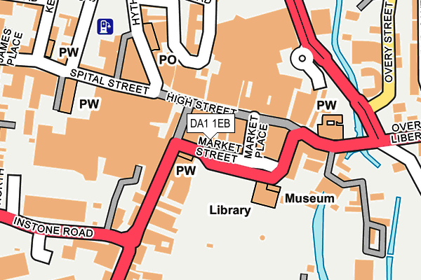
DA1 1EB is located in the Town electoral ward, within the local authority district of Dartford and the English Parliamentary constituency of Dartford. The Sub Integrated Care Board (ICB) Location is NHS Kent and Medway ICB - 91Q and the police force is Kent. This postcode has been in use since January 1995.


GetTheData
Source: OS OpenMap – Local (Ordnance Survey)
Source: OS VectorMap District (Ordnance Survey)
Licence: Open Government Licence (requires attribution)
| Easting | 554235 |
| Northing | 173984 |
| Latitude | 51.443850 |
| Longitude | 0.217940 |
GetTheData
Source: Open Postcode Geo
Licence: Open Government Licence
| Country | England |
| Postcode District | DA1 |
| ➜ DA1 open data dashboard ➜ See where DA1 is on a map ➜ Where is Dartford? | |
GetTheData
Source: Land Registry Price Paid Data
Licence: Open Government Licence
Elevation or altitude of DA1 1EB as distance above sea level:
| Metres | Feet | |
|---|---|---|
| Elevation | 10m | 33ft |
Elevation is measured from the approximate centre of the postcode, to the nearest point on an OS contour line from OS Terrain 50, which has contour spacing of ten vertical metres.
➜ How high above sea level am I? Find the elevation of your current position using your device's GPS.
GetTheData
Source: Open Postcode Elevation
Licence: Open Government Licence
| Ward | Town |
| Constituency | Dartford |
GetTheData
Source: ONS Postcode Database
Licence: Open Government Licence
| January 2024 | Burglary | On or near Parking Area | 126m |
| January 2024 | Other theft | On or near Parking Area | 380m |
| January 2024 | Burglary | On or near West View Road | 389m |
| ➜ Get more crime data in our Crime section | |||
GetTheData
Source: data.police.uk
Licence: Open Government Licence
| Market Street | Dartford | 43m |
| High Street | Dartford | 152m |
| Hanau Bridge (Home Gardens) | Dartford | 208m |
| Hanau Bridge (Home Gardens) | Dartford | 208m |
| Hanau Bridge (Home Gardens) | Dartford | 214m |
| Dartford Station | 0.4km |
| Crayford Station | 2.8km |
| Slade Green Station | 3.3km |
GetTheData
Source: NaPTAN
Licence: Open Government Licence
GetTheData
Source: ONS Postcode Database
Licence: Open Government Licence


➜ Get more ratings from the Food Standards Agency
GetTheData
Source: Food Standards Agency
Licence: FSA terms & conditions
| Last Collection | |||
|---|---|---|---|
| Location | Mon-Fri | Sat | Distance |
| High Street | 18:30 | 12:15 | 57m |
| Dartford Station | 18:30 | 12:00 | 382m |
| Dene Road | 18:30 | 11:00 | 567m |
GetTheData
Source: Dracos
Licence: Creative Commons Attribution-ShareAlike
| Facility | Distance |
|---|---|
| Acacia Fitness (Closed) High Street, Dartford Sports Hall, Health and Fitness Gym, Grass Pitches, Studio, Squash Courts, Outdoor Tennis Courts | 178m |
| The Gym Group (Dartford) The Orchards, Dartford Health and Fitness Gym | 180m |
| Central Park Arena Cranford Road, Dartford Athletics, Grass Pitches | 304m |
GetTheData
Source: Active Places
Licence: Open Government Licence
| School | Phase of Education | Distance |
|---|---|---|
| Westgate Primary School Summerhill Road, Dartford, DA1 2LP | Primary | 472m |
| Our Lady's Catholic Primary School, Dartford King Edward Avenue, Dartford, DA1 2HX | Primary | 760m |
| Dartford Primary Academy York Road, Dartford, DA1 1SQ | Primary | 785m |
GetTheData
Source: Edubase
Licence: Open Government Licence
| Risk of DA1 1EB flooding from rivers and sea | Medium |
| ➜ DA1 1EB flood map | |
GetTheData
Source: Open Flood Risk by Postcode
Licence: Open Government Licence
The below table lists the International Territorial Level (ITL) codes (formerly Nomenclature of Territorial Units for Statistics (NUTS) codes) and Local Administrative Units (LAU) codes for DA1 1EB:
| ITL 1 Code | Name |
|---|---|
| TLJ | South East (England) |
| ITL 2 Code | Name |
| TLJ4 | Kent |
| ITL 3 Code | Name |
| TLJ43 | Kent Thames Gateway |
| LAU 1 Code | Name |
| E07000107 | Dartford |
GetTheData
Source: ONS Postcode Directory
Licence: Open Government Licence
The below table lists the Census Output Area (OA), Lower Layer Super Output Area (LSOA), and Middle Layer Super Output Area (MSOA) for DA1 1EB:
| Code | Name | |
|---|---|---|
| OA | E00122764 | |
| LSOA | E01024182 | Dartford 003C |
| MSOA | E02005030 | Dartford 003 |
GetTheData
Source: ONS Postcode Directory
Licence: Open Government Licence
| DA1 1EY | Market Street | 17m |
| DA1 1DT | High Street | 32m |
| DA1 1EX | Market Place | 46m |
| DA1 1HD | Lowfield Street | 56m |
| DA1 1EN | Lowfield Street | 59m |
| DA1 1BZ | High Street | 63m |
| DA1 1DQ | High Street | 80m |
| DA1 1DS | High Street | 105m |
| DA1 1DE | High Street | 110m |
| DA1 1ET | Market Street | 122m |
GetTheData
Source: Open Postcode Geo; Land Registry Price Paid Data
Licence: Open Government Licence