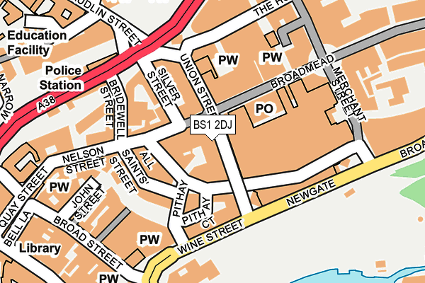
BS1 2DJ is located in the Central electoral ward, within the unitary authority of Bristol, City of and the English Parliamentary constituency of Bristol West. The Sub Integrated Care Board (ICB) Location is NHS Bristol, North Somerset and South Gloucestershire ICB - 15C and the police force is Avon and Somerset. This postcode has been in use since January 1980.


GetTheData
Source: OS OpenMap – Local (Ordnance Survey)
Source: OS VectorMap District (Ordnance Survey)
Licence: Open Government Licence (requires attribution)
| Easting | 359008 |
| Northing | 173235 |
| Latitude | 51.456598 |
| Longitude | -2.591371 |
GetTheData
Source: Open Postcode Geo
Licence: Open Government Licence
| Country | England |
| Postcode District | BS1 |
| ➜ BS1 open data dashboard ➜ See where BS1 is on a map ➜ Where is Bristol? | |
GetTheData
Source: Land Registry Price Paid Data
Licence: Open Government Licence
Elevation or altitude of BS1 2DJ as distance above sea level:
| Metres | Feet | |
|---|---|---|
| Elevation | 10m | 33ft |
Elevation is measured from the approximate centre of the postcode, to the nearest point on an OS contour line from OS Terrain 50, which has contour spacing of ten vertical metres.
➜ How high above sea level am I? Find the elevation of your current position using your device's GPS.
GetTheData
Source: Open Postcode Elevation
Licence: Open Government Licence
| Ward | Central |
| Constituency | Bristol West |
GetTheData
Source: ONS Postcode Database
Licence: Open Government Licence
| January 2024 | Other crime | On or near Rupert Street | 228m |
| January 2024 | Anti-social behaviour | On or near Nightclub | 323m |
| January 2024 | Anti-social behaviour | On or near Nightclub | 323m |
| ➜ Get more crime data in our Crime section | |||
GetTheData
Source: data.police.uk
Licence: Open Government Licence
| Union Street | Broadmead | 10m |
| Union Street | Broadmead | 22m |
| Union Street | Broadmead | 50m |
| Nelson Street | Broadmead | 87m |
| Union Street | Broadmead | 111m |
| Bristol Temple Meads Station | 1.1km |
| Montpelier Station | 1.3km |
| Redland Station | 1.4km |
GetTheData
Source: NaPTAN
Licence: Open Government Licence
GetTheData
Source: ONS Postcode Database
Licence: Open Government Licence


➜ Get more ratings from the Food Standards Agency
GetTheData
Source: Food Standards Agency
Licence: FSA terms & conditions
| Last Collection | |||
|---|---|---|---|
| Location | Mon-Fri | Sat | Distance |
| Union Street | 18:00 | 13:00 | 62m |
| The Galleries Post Office | 17:30 | 13:00 | 84m |
| Wine Street | 18:00 | 13:00 | 120m |
GetTheData
Source: Dracos
Licence: Creative Commons Attribution-ShareAlike
| Facility | Distance |
|---|---|
| Carrefour Health & Beauty (Bristol) (Closed) Union Street, Bristol Health and Fitness Gym, Studio | 39m |
| Fitness4less (Bristol) (Closed) All Saints Street, City Centre, Bristol Health and Fitness Gym, Studio | 96m |
| Puregym (Bristol Union Gate) Union Street, Bristol Health and Fitness Gym, Studio | 121m |
GetTheData
Source: Active Places
Licence: Open Government Licence
| School | Phase of Education | Distance |
|---|---|---|
| Willow Park CofE Primary School Park Lane, St Michael's Hill, BS2 8BE | Primary | 532m |
| Rosemary Nursery School and Children's Centre Haviland House, St Judes, Great Ann Street, Bristol, BS2 0DT | Nursery | 789m |
| St Pauls Nursery School & Children's Centre Little Bishop Street, St Paul's, Bristol, BS2 9JF | Nursery | 837m |
GetTheData
Source: Edubase
Licence: Open Government Licence
| Risk of BS1 2DJ flooding from rivers and sea | Low |
| ➜ BS1 2DJ flood map | |
GetTheData
Source: Open Flood Risk by Postcode
Licence: Open Government Licence
The below table lists the International Territorial Level (ITL) codes (formerly Nomenclature of Territorial Units for Statistics (NUTS) codes) and Local Administrative Units (LAU) codes for BS1 2DJ:
| ITL 1 Code | Name |
|---|---|
| TLK | South West (England) |
| ITL 2 Code | Name |
| TLK1 | Gloucestershire, Wiltshire and Bath/Bristol area |
| ITL 3 Code | Name |
| TLK11 | Bristol, City of |
| LAU 1 Code | Name |
| E06000023 | Bristol, City of |
GetTheData
Source: ONS Postcode Directory
Licence: Open Government Licence
The below table lists the Census Output Area (OA), Lower Layer Super Output Area (LSOA), and Middle Layer Super Output Area (MSOA) for BS1 2DJ:
| Code | Name | |
|---|---|---|
| OA | E00174294 | |
| LSOA | E01014540 | Bristol 032B |
| MSOA | E02003043 | Bristol 032 |
GetTheData
Source: ONS Postcode Directory
Licence: Open Government Licence
| BS1 3DT | Broadmead | 71m |
| BS1 3DW | Broadmead | 91m |
| BS1 2DL | Union Street | 93m |
| BS1 2BD | Wine Street | 116m |
| BS1 2AG | Silver Street | 132m |
| BS1 2EY | Tailors Court | 160m |
| BS1 2HR | John Street | 196m |
| BS1 3EE | Merchant Street | 198m |
| BS1 2EP | Broad Street | 213m |
| BS1 3JE | The Horsefair | 215m |
GetTheData
Source: Open Postcode Geo; Land Registry Price Paid Data
Licence: Open Government Licence