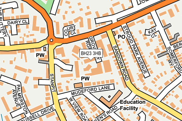
BH23 3HB lies on Groveley Road in Christchurch. BH23 3HB is located in the Christchurch Town electoral ward, within the unitary authority of Bournemouth, Christchurch and Poole and the English Parliamentary constituency of Christchurch. The Sub Integrated Care Board (ICB) Location is NHS Dorset ICB - 11J and the police force is Dorset. This postcode has been in use since January 1980.


GetTheData
Source: OS OpenMap – Local (Ordnance Survey)
Source: OS VectorMap District (Ordnance Survey)
Licence: Open Government Licence (requires attribution)
| Easting | 417174 |
| Northing | 92905 |
| Latitude | 50.735497 |
| Longitude | -1.757996 |
GetTheData
Source: Open Postcode Geo
Licence: Open Government Licence
| Street | Groveley Road |
| Town/City | Christchurch |
| Country | England |
| Postcode District | BH23 |
| ➜ BH23 open data dashboard ➜ See where BH23 is on a map ➜ Where is Christchurch? | |
GetTheData
Source: Land Registry Price Paid Data
Licence: Open Government Licence
Elevation or altitude of BH23 3HB as distance above sea level:
| Metres | Feet | |
|---|---|---|
| Elevation | 10m | 33ft |
Elevation is measured from the approximate centre of the postcode, to the nearest point on an OS contour line from OS Terrain 50, which has contour spacing of ten vertical metres.
➜ How high above sea level am I? Find the elevation of your current position using your device's GPS.
GetTheData
Source: Open Postcode Elevation
Licence: Open Government Licence
| Ward | Christchurch Town |
| Constituency | Christchurch |
GetTheData
Source: ONS Postcode Database
Licence: Open Government Licence
| December 2023 | Possession of weapons | On or near West View Road | 170m |
| December 2023 | Criminal damage and arson | On or near Ladysmith Close | 325m |
| November 2023 | Anti-social behaviour | On or near Ladysmith Close | 325m |
| ➜ Groveley Road crime map and outcomes | |||
GetTheData
Source: data.police.uk
Licence: Open Government Licence
| Purewell Cross (Somerford Road) | Purewell | 82m |
| Purewell Cross (Somerford Road) | Purewell | 90m |
| Purewell Close (Stanpit) | Purewell | 124m |
| Purewell Close (Stanpit) | Purewell | 135m |
| Medical Centre (Purewell Cross Road) | Purewell | 185m |
| Christchurch Station | 1.9km |
| Hinton Admiral Station | 3.6km |
| Pokesdown Station | 4.8km |
GetTheData
Source: NaPTAN
Licence: Open Government Licence
GetTheData
Source: ONS Postcode Database
Licence: Open Government Licence


➜ Get more ratings from the Food Standards Agency
GetTheData
Source: Food Standards Agency
Licence: FSA terms & conditions
| Last Collection | |||
|---|---|---|---|
| Location | Mon-Fri | Sat | Distance |
| Purewell Cross P.o. | 17:30 | 12:30 | 119m |
| Purewell Court | 09:00 | 09:00 | 128m |
| Queens Road | 17:30 | 12:30 | 257m |
GetTheData
Source: Dracos
Licence: Creative Commons Attribution-ShareAlike
| Facility | Distance |
|---|---|
| Snap Fitness (Christchurch) Somerford Road, Christchurch Health and Fitness Gym, Studio | 310m |
| Somerford Primary Community School Draper Road, Christchurch Grass Pitches | 433m |
| Stanpit Recreation Ground (Closed) Stanpit, Christchurch Grass Pitches | 548m |
GetTheData
Source: Active Places
Licence: Open Government Licence
| School | Phase of Education | Distance |
|---|---|---|
| Mudeford Community Infants' School Queen's Road, Mudeford, Christchurch, BH23 3HH | Primary | 154m |
| Somerford Primary School Draper Road, Christchurch, BH23 3AS | Primary | 433m |
| Mudeford Junior School Mudeford Lane, Mudeford, Christchurch, BH23 3HP | Primary | 620m |
GetTheData
Source: Edubase
Licence: Open Government Licence
| Risk of BH23 3HB flooding from rivers and sea | Low |
| ➜ BH23 3HB flood map | |
GetTheData
Source: Open Flood Risk by Postcode
Licence: Open Government Licence
The below table lists the International Territorial Level (ITL) codes (formerly Nomenclature of Territorial Units for Statistics (NUTS) codes) and Local Administrative Units (LAU) codes for BH23 3HB:
| ITL 1 Code | Name |
|---|---|
| TLK | South West (England) |
| ITL 2 Code | Name |
| TLK2 | Dorset and Somerset |
| ITL 3 Code | Name |
| TLK24 | Bournemouth, Christchurch and Poole |
| LAU 1 Code | Name |
| E06000058 | Bournemouth, Christchurch and Poole |
GetTheData
Source: ONS Postcode Directory
Licence: Open Government Licence
The below table lists the Census Output Area (OA), Lower Layer Super Output Area (LSOA), and Middle Layer Super Output Area (MSOA) for BH23 3HB:
| Code | Name | |
|---|---|---|
| OA | E00103175 | |
| LSOA | E01020362 | Christchurch 007D |
| MSOA | E02004242 | Christchurch 007 |
GetTheData
Source: ONS Postcode Directory
Licence: Open Government Licence
| BH23 3HL | Mudeford Lane | 78m |
| BH23 3PT | Purewell Close | 83m |
| BH23 3PH | Somerford Road | 91m |
| BH23 3HG | Sandown Road | 100m |
| BH23 3LR | Stanpit | 102m |
| BH23 3LZ | Stanpit | 142m |
| BH23 3PG | Court Close | 142m |
| BH23 3JQ | Pauntley Road | 142m |
| BH23 3PL | Somerford Road | 146m |
| BH23 3HQ | Stroud Park Avenue | 147m |
GetTheData
Source: Open Postcode Geo; Land Registry Price Paid Data
Licence: Open Government Licence