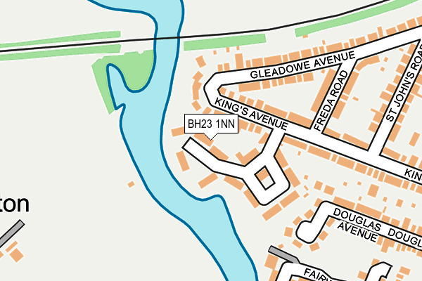
BH23 1NN is located in the Christchurch Town electoral ward, within the unitary authority of Bournemouth, Christchurch and Poole and the English Parliamentary constituency of Christchurch. The Sub Integrated Care Board (ICB) Location is NHS Dorset ICB - 11J and the police force is Dorset. This postcode has been in use since January 1980.


GetTheData
Source: OS OpenMap – Local (Ordnance Survey)
Source: OS VectorMap District (Ordnance Survey)
Licence: Open Government Licence (requires attribution)
| Easting | 414757 |
| Northing | 92859 |
| Latitude | 50.735160 |
| Longitude | -1.792254 |
GetTheData
Source: Open Postcode Geo
Licence: Open Government Licence
| Country | England |
| Postcode District | BH23 |
| ➜ BH23 open data dashboard ➜ See where BH23 is on a map ➜ Where is Christchurch? | |
GetTheData
Source: Land Registry Price Paid Data
Licence: Open Government Licence
Elevation or altitude of BH23 1NN as distance above sea level:
| Metres | Feet | |
|---|---|---|
| Elevation | 0m | 0ft |
Elevation is measured from the approximate centre of the postcode, to the nearest point on an OS contour line from OS Terrain 50, which has contour spacing of ten vertical metres.
➜ How high above sea level am I? Find the elevation of your current position using your device's GPS.
GetTheData
Source: Open Postcode Elevation
Licence: Open Government Licence
| Ward | Christchurch Town |
| Constituency | Christchurch |
GetTheData
Source: ONS Postcode Database
Licence: Open Government Licence
| June 2023 | Public order | On or near The Meridians | 401m |
| April 2023 | Violence and sexual offences | On or near The Meridians | 401m |
| August 2022 | Vehicle crime | On or near The Meridians | 401m |
| ➜ Get more crime data in our Crime section | |||
GetTheData
Source: data.police.uk
Licence: Open Government Licence
| Homelands Estate (King's Avenue) | Christchurch | 90m |
| Freda Road (Gleadowe Avenue) | Christchurch | 225m |
| Manor Road (King's Avenue) | Christchurch | 324m |
| King's Avenue (Stour Road) | Christchurch | 409m |
| Riverland Court (Stour Road) | Christchurch | 427m |
| Christchurch Station | 0.6km |
| Pokesdown Station | 2.4km |
GetTheData
Source: NaPTAN
Licence: Open Government Licence
| Percentage of properties with Next Generation Access | 100.0% |
| Percentage of properties with Superfast Broadband | 100.0% |
| Percentage of properties with Ultrafast Broadband | 0.0% |
| Percentage of properties with Full Fibre Broadband | 0.0% |
Superfast Broadband is between 30Mbps and 300Mbps
Ultrafast Broadband is > 300Mbps
| Percentage of properties unable to receive 2Mbps | 0.0% |
| Percentage of properties unable to receive 5Mbps | 0.0% |
| Percentage of properties unable to receive 10Mbps | 0.0% |
| Percentage of properties unable to receive 30Mbps | 0.0% |
GetTheData
Source: Ofcom
Licence: Ofcom Terms of Use (requires attribution)
GetTheData
Source: ONS Postcode Database
Licence: Open Government Licence


➜ Get more ratings from the Food Standards Agency
GetTheData
Source: Food Standards Agency
Licence: FSA terms & conditions
| Last Collection | |||
|---|---|---|---|
| Location | Mon-Fri | Sat | Distance |
| Kings Ave | 17:30 | 12:30 | 97m |
| Wentworth Drive | 17:30 | 12:30 | 388m |
| Seafield Road | 17:15 | 12:30 | 426m |
GetTheData
Source: Dracos
Licence: Creative Commons Attribution-ShareAlike
| Facility | Distance |
|---|---|
| Southbourne Tennis Club Iford Lane, Bournemouth Outdoor Tennis Courts | 334m |
| Iford Lane Playing Fields Iford Lane, Bournemouth Grass Pitches, Cycling | 349m |
| Christchurch Junior School Clarendon Road, Christchurch Grass Pitches | 615m |
GetTheData
Source: Active Places
Licence: Open Government Licence
| School | Phase of Education | Distance |
|---|---|---|
| Futures Autism Unlimited 6 Manor Road, Christchurch, BH23 1LU | Not applicable | 434m |
| Christchurch Junior School Clarendon Road, Christchurch, BH23 2AA | Primary | 613m |
| Christchurch Learning Centre 29 Stour Road, Christchurch, BH23 1PJ | Not applicable | 614m |
GetTheData
Source: Edubase
Licence: Open Government Licence
| Risk of BH23 1NN flooding from rivers and sea | Low |
| ➜ BH23 1NN flood map | |
GetTheData
Source: Open Flood Risk by Postcode
Licence: Open Government Licence
The below table lists the International Territorial Level (ITL) codes (formerly Nomenclature of Territorial Units for Statistics (NUTS) codes) and Local Administrative Units (LAU) codes for BH23 1NN:
| ITL 1 Code | Name |
|---|---|
| TLK | South West (England) |
| ITL 2 Code | Name |
| TLK2 | Dorset and Somerset |
| ITL 3 Code | Name |
| TLK24 | Bournemouth, Christchurch and Poole |
| LAU 1 Code | Name |
| E06000058 | Bournemouth, Christchurch and Poole |
GetTheData
Source: ONS Postcode Directory
Licence: Open Government Licence
The below table lists the Census Output Area (OA), Lower Layer Super Output Area (LSOA), and Middle Layer Super Output Area (MSOA) for BH23 1NN:
| Code | Name | |
|---|---|---|
| OA | E00103211 | |
| LSOA | E01020368 | Christchurch 006E |
| MSOA | E02004241 | Christchurch 006 |
GetTheData
Source: ONS Postcode Directory
Licence: Open Government Licence
| BH23 1NA | Kings Avenue | 126m |
| BH23 1LS | Gleadowe Avenue | 151m |
| BH23 1NB | Kings Avenue | 168m |
| BH23 1JU | Galton Avenue | 191m |
| BH23 1LY | Freda Road | 204m |
| BH23 1JZ | Fairway Drive | 213m |
| BH23 1JT | Douglas Avenue | 282m |
| BH23 1JY | Fairway Drive | 292m |
| BH23 1LX | St Johns Road | 300m |
| BH23 1LZ | Kings Avenue | 301m |
GetTheData
Source: Open Postcode Geo; Land Registry Price Paid Data
Licence: Open Government Licence