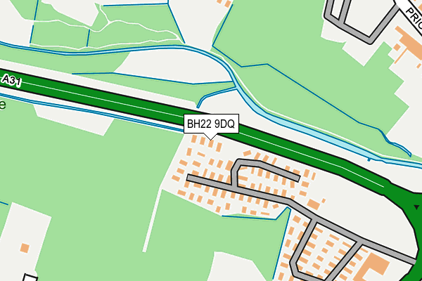
BH22 9DQ is located in the Ferndown North electoral ward, within the unitary authority of Dorset and the English Parliamentary constituency of Christchurch. The Sub Integrated Care Board (ICB) Location is NHS Dorset ICB - 11J and the police force is Dorset. This postcode has been in use since December 1996.


GetTheData
Source: OS OpenMap – Local (Ordnance Survey)
Source: OS VectorMap District (Ordnance Survey)
Licence: Open Government Licence (requires attribution)
| Easting | 408763 |
| Northing | 101621 |
| Latitude | 50.814073 |
| Longitude | -1.876985 |
GetTheData
Source: Open Postcode Geo
Licence: Open Government Licence
| Country | England |
| Postcode District | BH22 |
| ➜ BH22 open data dashboard ➜ See where BH22 is on a map ➜ Where is Trickett's Cross? | |
GetTheData
Source: Land Registry Price Paid Data
Licence: Open Government Licence
Elevation or altitude of BH22 9DQ as distance above sea level:
| Metres | Feet | |
|---|---|---|
| Elevation | 20m | 66ft |
Elevation is measured from the approximate centre of the postcode, to the nearest point on an OS contour line from OS Terrain 50, which has contour spacing of ten vertical metres.
➜ How high above sea level am I? Find the elevation of your current position using your device's GPS.
GetTheData
Source: Open Postcode Elevation
Licence: Open Government Licence
| Ward | Ferndown North |
| Constituency | Christchurch |
GetTheData
Source: ONS Postcode Database
Licence: Open Government Licence
| June 2022 | Anti-social behaviour | On or near A31 | 142m |
| June 2022 | Anti-social behaviour | On or near Petrol Station | 289m |
| June 2022 | Shoplifting | On or near Petrol Station | 289m |
| ➜ Get more crime data in our Crime section | |||
GetTheData
Source: data.police.uk
Licence: Open Government Licence
| Sainsburys | Trickett's Cross | 265m |
| Sainsburys (Ringwood Road) | Trickett's Cross | 335m |
| Sainsburys (Ringwood Road) | Trickett's Cross | 384m |
| Coach House Mews | Ferndown | 443m |
| Abbey Road (Pinehurst Road) | West Moors | 447m |
GetTheData
Source: NaPTAN
Licence: Open Government Licence
GetTheData
Source: ONS Postcode Database
Licence: Open Government Licence


➜ Get more ratings from the Food Standards Agency
GetTheData
Source: Food Standards Agency
Licence: FSA terms & conditions
| Last Collection | |||
|---|---|---|---|
| Location | Mon-Fri | Sat | Distance |
| Sainsburys | 17:30 | 12:30 | 329m |
| Priory Estate P.o. | 17:00 | 12:00 | 452m |
| Abbey Road | 17:00 | 12:00 | 457m |
GetTheData
Source: Dracos
Licence: Creative Commons Attribution-ShareAlike
| Facility | Distance |
|---|---|
| Ford Lane Recreation Ground Ford Lane, Ferndown Grass Pitches | 470m |
| West Moors Middle School Heathfield Way, West Moors, Ferndown Sports Hall, Grass Pitches, Outdoor Tennis Courts | 681m |
| Oakhurst Community First School Shaftesbury Road, West Moors, Ferndown Grass Pitches | 955m |
GetTheData
Source: Active Places
Licence: Open Government Licence
| School | Phase of Education | Distance |
|---|---|---|
| West Moors Middle School Heathfield Way, West Moors, Ferndown, BH22 0DA | Middle deemed secondary | 681m |
| Oakhurst Community First School Shaftesbury Road, West Moors, Ferndown, BH22 0DY | Primary | 955m |
| St Mary's CofE First School & Nursery Station Road, West Moors, Ferndown, BH22 0JF | Primary | 1.9km |
GetTheData
Source: Edubase
Licence: Open Government Licence
| Risk of BH22 9DQ flooding from rivers and sea | Low |
| ➜ BH22 9DQ flood map | |
GetTheData
Source: Open Flood Risk by Postcode
Licence: Open Government Licence
The below table lists the International Territorial Level (ITL) codes (formerly Nomenclature of Territorial Units for Statistics (NUTS) codes) and Local Administrative Units (LAU) codes for BH22 9DQ:
| ITL 1 Code | Name |
|---|---|
| TLK | South West (England) |
| ITL 2 Code | Name |
| TLK2 | Dorset and Somerset |
| ITL 3 Code | Name |
| TLK25 | Dorset |
| LAU 1 Code | Name |
| E06000059 | Dorset |
GetTheData
Source: ONS Postcode Directory
Licence: Open Government Licence
The below table lists the Census Output Area (OA), Lower Layer Super Output Area (LSOA), and Middle Layer Super Output Area (MSOA) for BH22 9DQ:
| Code | Name | |
|---|---|---|
| OA | E00103329 | |
| LSOA | E01020390 | East Dorset 008A |
| MSOA | E02004250 | East Dorset 008 |
GetTheData
Source: ONS Postcode Directory
Licence: Open Government Licence
| BH22 9UZ | Coach House Mews | 311m |
| BH22 9UY | Coach House Mews | 341m |
| BH22 9LP | Woodland Walk | 350m |
| BH22 9UX | Coach House Mews | 370m |
| BH22 0AY | Priory Road | 373m |
| BH22 9UU | Coach House Mews | 377m |
| BH22 9BB | Ringwood Road | 382m |
| BH22 0AF | Priory Gardens | 399m |
| BH22 9UT | Coach House Mews | 402m |
| BH22 9BA | Ringwood Road | 410m |
GetTheData
Source: Open Postcode Geo; Land Registry Price Paid Data
Licence: Open Government Licence