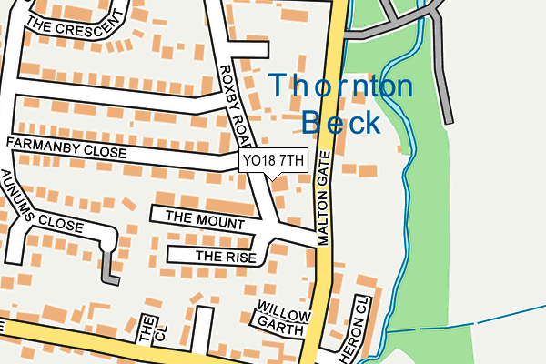
YO18 7TH lies on Jessamine Villas in Thornton Dale, Pickering. YO18 7TH is located in the Thornton Dale & Wolds electoral ward, within the unitary authority of North Yorkshire and the English Parliamentary constituency of Thirsk and Malton. The Sub Integrated Care Board (ICB) Location is NHS Humber and North Yorkshire ICB - 03Q and the police force is North Yorkshire. This postcode has been in use since January 1980.


GetTheData
Source: OS OpenMap – Local (Ordnance Survey)
Source: OS VectorMap District (Ordnance Survey)
Licence: Open Government Licence (requires attribution)
| Easting | 483307 |
| Northing | 482556 |
| Latitude | 54.231946 |
| Longitude | -0.723488 |
GetTheData
Source: Open Postcode Geo
Licence: Open Government Licence
| Street | Jessamine Villas |
| Locality | Thornton Dale |
| Town/City | Pickering |
| Country | England |
| Postcode District | YO18 |
| ➜ YO18 open data dashboard ➜ See where YO18 is on a map ➜ Where is Thornton-le-Dale? | |
GetTheData
Source: Land Registry Price Paid Data
Licence: Open Government Licence
Elevation or altitude of YO18 7TH as distance above sea level:
| Metres | Feet | |
|---|---|---|
| Elevation | 30m | 98ft |
Elevation is measured from the approximate centre of the postcode, to the nearest point on an OS contour line from OS Terrain 50, which has contour spacing of ten vertical metres.
➜ How high above sea level am I? Find the elevation of your current position using your device's GPS.
GetTheData
Source: Open Postcode Elevation
Licence: Open Government Licence
| Ward | Thornton Dale & Wolds |
| Constituency | Thirsk And Malton |
GetTheData
Source: ONS Postcode Database
Licence: Open Government Licence
| August 2022 | Other theft | On or near Roxby Gardens | 261m |
| April 2022 | Anti-social behaviour | On or near Willow Garth | 158m |
| April 2022 | Other theft | On or near Chapel Lane | 403m |
| ➜ Get more crime data in our Crime section | |||
GetTheData
Source: data.police.uk
Licence: Open Government Licence
| Nym Car Park (Malton Gate) | Thornton-le-dale | 436m |
| Thornton Cross (A170) | Thornton-le-dale | 487m |
| Thornton Cross (Chestnut Avenue) | Thornton-le-dale | 503m |
| Greengate Lane (A170) | Thornton-le-dale | 658m |
| Hilltop (Hurrell Lane) | Thornton-le-dale | 1,250m |
GetTheData
Source: NaPTAN
Licence: Open Government Licence
| Percentage of properties with Next Generation Access | 100.0% |
| Percentage of properties with Superfast Broadband | 100.0% |
| Percentage of properties with Ultrafast Broadband | 0.0% |
| Percentage of properties with Full Fibre Broadband | 0.0% |
Superfast Broadband is between 30Mbps and 300Mbps
Ultrafast Broadband is > 300Mbps
| Percentage of properties unable to receive 2Mbps | 0.0% |
| Percentage of properties unable to receive 5Mbps | 0.0% |
| Percentage of properties unable to receive 10Mbps | 0.0% |
| Percentage of properties unable to receive 30Mbps | 0.0% |
GetTheData
Source: Ofcom
Licence: Ofcom Terms of Use (requires attribution)
GetTheData
Source: ONS Postcode Database
Licence: Open Government Licence


➜ Get more ratings from the Food Standards Agency
GetTheData
Source: Food Standards Agency
Licence: FSA terms & conditions
| Last Collection | |||
|---|---|---|---|
| Location | Mon-Fri | Sat | Distance |
| Thornton Dale West End | 17:00 | 13:00 | 189m |
| Thornton Dale Post Office | 17:00 | 12:00 | 407m |
| Thornton Dale East End | 16:45 | 13:00 | 901m |
GetTheData
Source: Dracos
Licence: Creative Commons Attribution-ShareAlike
| Facility | Distance |
|---|---|
| Thornton Dale Sports Association Maltongate, Thornton-le-dale, Pickering Grass Pitches | 404m |
| Foston And Thornton-le-clay Village Hall Pickering Road, Thornton-le-dale, Pickering Sports Hall | 466m |
| Thornton Le Dale Squash Club Chestnut Avenue, Thornton-le-dale, Pickering Squash Courts | 584m |
GetTheData
Source: Active Places
Licence: Open Government Licence
| School | Phase of Education | Distance |
|---|---|---|
| Thornton Dale CofE Primary School Castle Close, Thornton-le-Dale, Pickering, YO18 7TW | Primary | 418m |
| Pickering Community Infant School Ruffa Lane, Pickering, YO18 7AT | Primary | 3.6km |
| Pickering Community Junior School Middleton Road, Pickering, YO18 8AJ | Primary | 4.4km |
GetTheData
Source: Edubase
Licence: Open Government Licence
The below table lists the International Territorial Level (ITL) codes (formerly Nomenclature of Territorial Units for Statistics (NUTS) codes) and Local Administrative Units (LAU) codes for YO18 7TH:
| ITL 1 Code | Name |
|---|---|
| TLE | Yorkshire and The Humber |
| ITL 2 Code | Name |
| TLE2 | North Yorkshire |
| ITL 3 Code | Name |
| TLE22 | North Yorkshire CC |
| LAU 1 Code | Name |
| E07000167 | Ryedale |
GetTheData
Source: ONS Postcode Directory
Licence: Open Government Licence
The below table lists the Census Output Area (OA), Lower Layer Super Output Area (LSOA), and Middle Layer Super Output Area (MSOA) for YO18 7TH:
| Code | Name | |
|---|---|---|
| OA | E00141620 | |
| LSOA | E01027801 | Ryedale 002E |
| MSOA | E02005789 | Ryedale 002 |
GetTheData
Source: ONS Postcode Directory
Licence: Open Government Licence
| YO18 7TQ | Roxby Road | 22m |
| YO18 7TB | Farmanby Close | 67m |
| YO18 7SU | Brookfield Gardens | 75m |
| YO18 7SD | Maltongate | 78m |
| YO18 7TF | The Mount | 79m |
| YO18 7TJ | Roxby Road | 97m |
| YO18 7TG | The Rise | 128m |
| YO18 7SW | Willow Garth | 162m |
| YO18 7TA | Roxby Road | 164m |
| YO18 7SQ | Westfield Terrace | 175m |
GetTheData
Source: Open Postcode Geo; Land Registry Price Paid Data
Licence: Open Government Licence