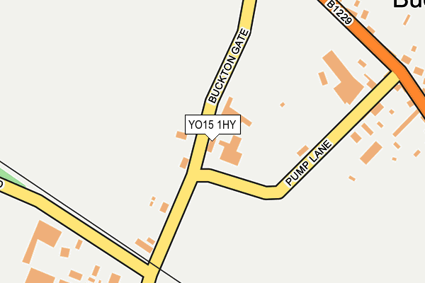
YO15 1HY is located in the Bridlington Central and Old Town electoral ward, within the unitary authority of East Riding of Yorkshire and the English Parliamentary constituency of East Yorkshire. The Sub Integrated Care Board (ICB) Location is NHS Humber and North Yorkshire ICB - 02Y and the police force is Humberside. This postcode has been in use since January 1980.


GetTheData
Source: OS OpenMap – Local (Ordnance Survey)
Source: OS VectorMap District (Ordnance Survey)
Licence: Open Government Licence (requires attribution)
| Easting | 518192 |
| Northing | 472505 |
| Latitude | 54.134806 |
| Longitude | -0.192512 |
GetTheData
Source: Open Postcode Geo
Licence: Open Government Licence
| Country | England |
| Postcode District | YO15 |
| ➜ YO15 open data dashboard ➜ See where YO15 is on a map ➜ Where is Buckton? | |
GetTheData
Source: Land Registry Price Paid Data
Licence: Open Government Licence
Elevation or altitude of YO15 1HY as distance above sea level:
| Metres | Feet | |
|---|---|---|
| Elevation | 80m | 262ft |
Elevation is measured from the approximate centre of the postcode, to the nearest point on an OS contour line from OS Terrain 50, which has contour spacing of ten vertical metres.
➜ How high above sea level am I? Find the elevation of your current position using your device's GPS.
GetTheData
Source: Open Postcode Elevation
Licence: Open Government Licence
| Ward | Bridlington Central And Old Town |
| Constituency | East Yorkshire |
GetTheData
Source: ONS Postcode Database
Licence: Open Government Licence
| March 2022 | Other theft | On or near Buckton Gate | 120m |
| December 2021 | Vehicle crime | On or near Main Street | 299m |
| November 2021 | Violence and sexual offences | On or near Main Street | 299m |
| ➜ Get more crime data in our Crime section | |||
GetTheData
Source: data.police.uk
Licence: Open Government Licence
| Buckton Main Street (Main Street) | Buckton | 286m |
| Buckton Main Street (Main Street) | Buckton | 301m |
| Bempton High Street (High Street) | Bempton | 550m |
| Bempton High Street (High Street) | Bempton | 584m |
| Bempton Newsham Hill Ln (Newsham Hill Lane) | Bempton | 1,015m |
| Bempton Station | 1.1km |
GetTheData
Source: NaPTAN
Licence: Open Government Licence
GetTheData
Source: ONS Postcode Database
Licence: Open Government Licence


➜ Get more ratings from the Food Standards Agency
GetTheData
Source: Food Standards Agency
Licence: FSA terms & conditions
| Last Collection | |||
|---|---|---|---|
| Location | Mon-Fri | Sat | Distance |
| 31 Main Street Buckton | 16:00 | 09:00 | 268m |
| Bempton Post Office | 16:00 | 10:45 | 905m |
| Jewison Lane | 16:30 | 11:30 | 3,123m |
GetTheData
Source: Dracos
Licence: Creative Commons Attribution-ShareAlike
| Facility | Distance |
|---|---|
| Martongate Primary School Martongate, Bridlington Grass Pitches | 4km |
| Headlands School Sewerby Road, Bridlington Grass Pitches, Sports Hall, Studio, Outdoor Tennis Courts | 4.1km |
| Burlington Junior School (Closed) Marton Road, Bridlington Swimming Pool | 4.2km |
GetTheData
Source: Active Places
Licence: Open Government Licence
| School | Phase of Education | Distance |
|---|---|---|
| Bempton Primary School 37 School Lane, Bempton, Bridlington, YO15 1JA | Primary | 788m |
| Martongate Primary School Martongate, Martongate Primary School, Bridlington, YO16 6YD | Primary | 4km |
| Headlands School Sewerby Road, Bridlington, YO16 6UR | Secondary | 4km |
GetTheData
Source: Edubase
Licence: Open Government Licence
The below table lists the International Territorial Level (ITL) codes (formerly Nomenclature of Territorial Units for Statistics (NUTS) codes) and Local Administrative Units (LAU) codes for YO15 1HY:
| ITL 1 Code | Name |
|---|---|
| TLE | Yorkshire and The Humber |
| ITL 2 Code | Name |
| TLE1 | East Yorkshire and Northern Lincolnshire |
| ITL 3 Code | Name |
| TLE12 | East Riding of Yorkshire |
| LAU 1 Code | Name |
| E06000011 | East Riding of Yorkshire |
GetTheData
Source: ONS Postcode Directory
Licence: Open Government Licence
The below table lists the Census Output Area (OA), Lower Layer Super Output Area (LSOA), and Middle Layer Super Output Area (MSOA) for YO15 1HY:
| Code | Name | |
|---|---|---|
| OA | E00065215 | |
| LSOA | E01012933 | East Riding of Yorkshire 001A |
| MSOA | E02002684 | East Riding of Yorkshire 001 |
GetTheData
Source: ONS Postcode Directory
Licence: Open Government Licence
| YO15 1DH | 47m | |
| YO15 1HZ | Pump Lane | 221m |
| YO15 1HU | Main Street | 270m |
| YO15 1HX | Hoddy Cows Lane | 366m |
| YO15 1HS | High Street | 572m |
| YO15 1HR | Bolam Lane | 622m |
| YO15 1JN | Walmsley Close | 630m |
| YO15 1HT | Scarsea Way | 640m |
| YO15 1JL | Grange Close | 708m |
| YO15 1JR | Ringley Meadows | 714m |
GetTheData
Source: Open Postcode Geo; Land Registry Price Paid Data
Licence: Open Government Licence