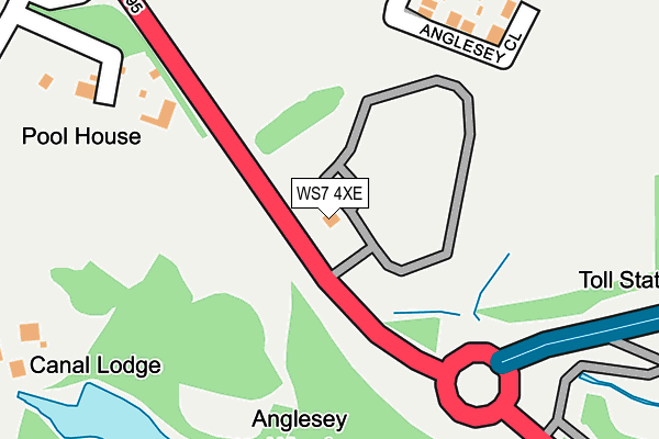
WS7 4XE is located in the Hammerwich with Wall electoral ward, within the local authority district of Lichfield and the English Parliamentary constituency of Lichfield. The Sub Integrated Care Board (ICB) Location is NHS Staffordshire and Stoke-on-Trent ICB - 05Q and the police force is Staffordshire. This postcode has been in use since October 2013.


GetTheData
Source: OS OpenMap – Local (Ordnance Survey)
Source: OS VectorMap District (Ordnance Survey)
Licence: Open Government Licence (requires attribution)
| Easting | 404381 |
| Northing | 307526 |
| Latitude | 52.665432 |
| Longitude | -1.936657 |
GetTheData
Source: Open Postcode Geo
Licence: Open Government Licence
| Country | England |
| Postcode District | WS7 |
| ➜ WS7 open data dashboard ➜ See where WS7 is on a map | |
GetTheData
Source: Land Registry Price Paid Data
Licence: Open Government Licence
Elevation or altitude of WS7 4XE as distance above sea level:
| Metres | Feet | |
|---|---|---|
| Elevation | 140m | 459ft |
Elevation is measured from the approximate centre of the postcode, to the nearest point on an OS contour line from OS Terrain 50, which has contour spacing of ten vertical metres.
➜ How high above sea level am I? Find the elevation of your current position using your device's GPS.
GetTheData
Source: Open Postcode Elevation
Licence: Open Government Licence
| Ward | Hammerwich With Wall |
| Constituency | Lichfield |
GetTheData
Source: ONS Postcode Database
Licence: Open Government Licence
| May 2022 | Violence and sexual offences | On or near Pool Road | 295m |
| May 2022 | Violence and sexual offences | On or near St Anne'S Close | 480m |
| May 2022 | Violence and sexual offences | On or near St Anne'S Close | 480m |
| ➜ Get more crime data in our Crime section | |||
GetTheData
Source: data.police.uk
Licence: Open Government Licence
| King Street (Highfields Road) | Chasetown | 462m |
| King Street (Highfields Road) | Chasetown | 474m |
| Queen Street (High Street) | Chasetown | 517m |
| Queen Street (High Street) | Chasetown | 534m |
| Chestnut Court (Highfields Rd) | Chasetown | 543m |
| Hednesford Station | 6.6km |
GetTheData
Source: NaPTAN
Licence: Open Government Licence
GetTheData
Source: ONS Postcode Database
Licence: Open Government Licence


➜ Get more ratings from the Food Standards Agency
GetTheData
Source: Food Standards Agency
Licence: FSA terms & conditions
| Last Collection | |||
|---|---|---|---|
| Location | Mon-Fri | Sat | Distance |
| Chasetown Post Office | 18:00 | 12:00 | 729m |
| Whitehorse Road | 16:00 | 11:15 | 890m |
| Watling Street | 16:00 | 11:15 | 1,055m |
GetTheData
Source: Dracos
Licence: Creative Commons Attribution-ShareAlike
| Facility | Distance |
|---|---|
| Erasmus Darwin Academy Pool Road, Burntwood Artificial Grass Pitch, Grass Pitches, Health and Fitness Gym, Sports Hall, Studio, Outdoor Tennis Courts | 284m |
| Chasetown Leisure Centre (Closed) High Street, Chasetown, Burntwood Health and Fitness Gym, Studio | 527m |
| Chasetown Community School Church Street, Chasetown, Burntwood Grass Pitches | 572m |
GetTheData
Source: Active Places
Licence: Open Government Licence
| School | Phase of Education | Distance |
|---|---|---|
| Erasmus Darwin Academy Pool Road, Burntwood, WS7 3QW | Secondary | 321m |
| Chasetown Community School Church Street, Chasetown, Burntwood, WS7 3QL | Not applicable | 572m |
| Watling Street Primary School Watling Street, Brownhills, Walsall, WS8 7LW | Primary | 1km |
GetTheData
Source: Edubase
Licence: Open Government Licence
The below table lists the International Territorial Level (ITL) codes (formerly Nomenclature of Territorial Units for Statistics (NUTS) codes) and Local Administrative Units (LAU) codes for WS7 4XE:
| ITL 1 Code | Name |
|---|---|
| TLG | West Midlands (England) |
| ITL 2 Code | Name |
| TLG2 | Shropshire and Staffordshire |
| ITL 3 Code | Name |
| TLG24 | Staffordshire CC |
| LAU 1 Code | Name |
| E07000194 | Lichfield |
GetTheData
Source: ONS Postcode Directory
Licence: Open Government Licence
The below table lists the Census Output Area (OA), Lower Layer Super Output Area (LSOA), and Middle Layer Super Output Area (MSOA) for WS7 4XE:
| Code | Name | |
|---|---|---|
| OA | E00150297 | |
| LSOA | E01029497 | Lichfield 006E |
| MSOA | E02006151 | Lichfield 006 |
GetTheData
Source: ONS Postcode Directory
Licence: Open Government Licence
| WS7 3QP | Paviors Road | 243m |
| WS7 4XA | Anglesey Close | 251m |
| WS7 3QW | Pool Road | 350m |
| WS7 3QR | Church Walk | 406m |
| WS7 3QN | St Annes Close | 455m |
| WS7 3QL | Church Street | 466m |
| WS7 4QR | Highfields Road | 502m |
| WS8 7NR | Wyrley Close | 541m |
| WS7 4QU | Highfields Road | 559m |
| WS7 4QJ | King Street | 570m |
GetTheData
Source: Open Postcode Geo; Land Registry Price Paid Data
Licence: Open Government Licence