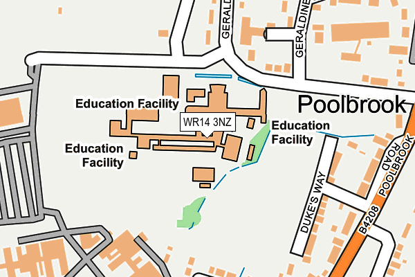
WR14 3NZ is located in the Barnards Green electoral ward, within the local authority district of Malvern Hills and the English Parliamentary constituency of West Worcestershire. The Sub Integrated Care Board (ICB) Location is NHS Herefordshire and Worcestershire ICB - 18C and the police force is West Mercia. This postcode has been in use since January 1980.


GetTheData
Source: OS OpenMap – Local (Ordnance Survey)
Source: OS VectorMap District (Ordnance Survey)
Licence: Open Government Licence (requires attribution)
| Easting | 378855 |
| Northing | 244964 |
| Latitude | 52.102602 |
| Longitude | -2.310121 |
GetTheData
Source: Open Postcode Geo
Licence: Open Government Licence
| Country | England |
| Postcode District | WR14 |
| ➜ WR14 open data dashboard ➜ See where WR14 is on a map ➜ Where is Great Malvern? | |
GetTheData
Source: Land Registry Price Paid Data
Licence: Open Government Licence
Elevation or altitude of WR14 3NZ as distance above sea level:
| Metres | Feet | |
|---|---|---|
| Elevation | 60m | 197ft |
Elevation is measured from the approximate centre of the postcode, to the nearest point on an OS contour line from OS Terrain 50, which has contour spacing of ten vertical metres.
➜ How high above sea level am I? Find the elevation of your current position using your device's GPS.
GetTheData
Source: Open Postcode Elevation
Licence: Open Government Licence
| Ward | Barnards Green |
| Constituency | West Worcestershire |
GetTheData
Source: ONS Postcode Database
Licence: Open Government Licence
| June 2022 | Violence and sexual offences | On or near Sports/Recreation Area | 193m |
| June 2022 | Violence and sexual offences | On or near Sports/Recreation Area | 193m |
| June 2022 | Violence and sexual offences | On or near Sports/Recreation Area | 193m |
| ➜ Get more crime data in our Crime section | |||
GetTheData
Source: data.police.uk
Licence: Open Government Licence
| Chase Technology College (Geraldine Road) | Poolbrook | 108m |
| Poolbrook Road Shops (Poolbrook Road) | Poolbrook | 257m |
| Poolbrook Road Shops (Poolbrook Road) | Poolbrook | 277m |
| Churchdown Road (Poolbrook Road) | Poolbrook | 359m |
| Churchdown Road (Poolbrook Road) | Poolbrook | 363m |
| Great Malvern Station | 0.9km |
| Malvern Link Station | 2.6km |
| Colwall Station | 4.1km |
GetTheData
Source: NaPTAN
Licence: Open Government Licence
GetTheData
Source: ONS Postcode Database
Licence: Open Government Licence


➜ Get more ratings from the Food Standards Agency
GetTheData
Source: Food Standards Agency
Licence: FSA terms & conditions
| Last Collection | |||
|---|---|---|---|
| Location | Mon-Fri | Sat | Distance |
| Poolbrook P.o. | 17:15 | 11:15 | 239m |
| Brook Farm | 17:15 | 11:15 | 431m |
| Barnards Green P.o. | 17:30 | 11:30 | 656m |
GetTheData
Source: Dracos
Licence: Creative Commons Attribution-ShareAlike
| Facility | Distance |
|---|---|
| The Chase School Geraldine Road, Malvern Sports Hall, Artificial Grass Pitch, Grass Pitches, Studio, Outdoor Tennis Courts | 0m |
| The Scout Hut Dukes Way, Malvern Sports Hall | 225m |
| Poolbrook Village Hall Poolbrook Road, Malvern Sports Hall | 327m |
GetTheData
Source: Active Places
Licence: Open Government Licence
| School | Phase of Education | Distance |
|---|---|---|
| The Chase Geraldine Road, Malvern, WR14 3NZ | Secondary | 0m |
| Malvern Parish CofE Primary School Manby Road, Malvern, WR14 3BB | Primary | 806m |
| Great Malvern Primary School Lydes Road, Malvern, WR14 2BY | Primary | 898m |
GetTheData
Source: Edubase
Licence: Open Government Licence
The below table lists the International Territorial Level (ITL) codes (formerly Nomenclature of Territorial Units for Statistics (NUTS) codes) and Local Administrative Units (LAU) codes for WR14 3NZ:
| ITL 1 Code | Name |
|---|---|
| TLG | West Midlands (England) |
| ITL 2 Code | Name |
| TLG1 | Herefordshire, Worcestershire and Warwickshire |
| ITL 3 Code | Name |
| TLG12 | Worcestershire CC |
| LAU 1 Code | Name |
| E07000235 | Malvern Hills |
GetTheData
Source: ONS Postcode Directory
Licence: Open Government Licence
The below table lists the Census Output Area (OA), Lower Layer Super Output Area (LSOA), and Middle Layer Super Output Area (MSOA) for WR14 3NZ:
| Code | Name | |
|---|---|---|
| OA | E00164161 | |
| LSOA | E01032184 | Malvern Hills 009A |
| MSOA | E02006718 | Malvern Hills 009 |
GetTheData
Source: ONS Postcode Directory
Licence: Open Government Licence
| WR14 3NU | Geraldine Road | 143m |
| WR14 3NX | Geraldine Road | 154m |
| WR14 3JE | Dukes Way | 188m |
| WR14 3PB | Geraldine Road | 231m |
| WR14 3JD | Poolbrook Road | 241m |
| WR14 3JF | Poolbrook Road | 245m |
| WR14 3PF | Geraldine Close | 265m |
| WR14 3NW | Poolbrook Road | 277m |
| WR14 3LG | Britten Drive | 283m |
| WR14 3JG | Poolbrook Road | 286m |
GetTheData
Source: Open Postcode Geo; Land Registry Price Paid Data
Licence: Open Government Licence