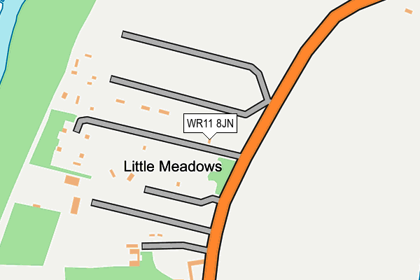
WR11 8JN is located in the Honeybourne, Pebworth & The Littletons electoral ward, within the local authority district of Wychavon and the English Parliamentary constituency of Mid Worcestershire. The Sub Integrated Care Board (ICB) Location is NHS Herefordshire and Worcestershire ICB - 18C and the police force is West Mercia. This postcode has been in use since December 2001.


GetTheData
Source: OS OpenMap – Local (Ordnance Survey)
Source: OS VectorMap District (Ordnance Survey)
Licence: Open Government Licence (requires attribution)
| Easting | 407861 |
| Northing | 249071 |
| Latitude | 52.139880 |
| Longitude | -1.886553 |
GetTheData
Source: Open Postcode Geo
Licence: Open Government Licence
| Country | England |
| Postcode District | WR11 |
| ➜ WR11 open data dashboard ➜ See where WR11 is on a map | |
GetTheData
Source: Land Registry Price Paid Data
Licence: Open Government Licence
Elevation or altitude of WR11 8JN as distance above sea level:
| Metres | Feet | |
|---|---|---|
| Elevation | 50m | 164ft |
Elevation is measured from the approximate centre of the postcode, to the nearest point on an OS contour line from OS Terrain 50, which has contour spacing of ten vertical metres.
➜ How high above sea level am I? Find the elevation of your current position using your device's GPS.
GetTheData
Source: Open Postcode Elevation
Licence: Open Government Licence
| Ward | Honeybourne, Pebworth & The Littletons |
| Constituency | Mid Worcestershire |
GetTheData
Source: ONS Postcode Database
Licence: Open Government Licence
| June 2022 | Violence and sexual offences | On or near Evesham Road | 207m |
| June 2022 | Criminal damage and arson | On or near Evesham Road | 207m |
| June 2022 | Criminal damage and arson | On or near Evesham Road | 207m |
| ➜ Get more crime data in our Crime section | |||
GetTheData
Source: data.police.uk
Licence: Open Government Licence
| Buckthorn Farm (Evesham Road) | Cleeve Prior | 317m |
| Buckthorn Farm (Evesham Road) | Cleeve Prior | 318m |
| Back Lane (Main Street) | Cleeve Prior | 700m |
| Back Lane (Main Street) | Cleeve Prior | 734m |
| The Green | Cleeve Prior | 815m |
| Honeybourne Station | 5.6km |
| Evesham Station | 6.2km |
GetTheData
Source: NaPTAN
Licence: Open Government Licence
| Percentage of properties with Next Generation Access | 100.0% |
| Percentage of properties with Superfast Broadband | 100.0% |
| Percentage of properties with Ultrafast Broadband | 100.0% |
| Percentage of properties with Full Fibre Broadband | 100.0% |
Superfast Broadband is between 30Mbps and 300Mbps
Ultrafast Broadband is > 300Mbps
| Percentage of properties unable to receive 2Mbps | 0.0% |
| Percentage of properties unable to receive 5Mbps | 0.0% |
| Percentage of properties unable to receive 10Mbps | 0.0% |
| Percentage of properties unable to receive 30Mbps | 0.0% |
GetTheData
Source: Ofcom
Licence: Ofcom Terms of Use (requires attribution)
GetTheData
Source: ONS Postcode Database
Licence: Open Government Licence


➜ Get more ratings from the Food Standards Agency
GetTheData
Source: Food Standards Agency
Licence: FSA terms & conditions
| Last Collection | |||
|---|---|---|---|
| Location | Mon-Fri | Sat | Distance |
| Cleeve Prior P.o. | 16:30 | 09:15 | 846m |
| Abbots Salford | 16:45 | 10:30 | 1,562m |
| North Littleton | 16:30 | 09:15 | 1,688m |
GetTheData
Source: Dracos
Licence: Creative Commons Attribution-ShareAlike
| Facility | Distance |
|---|---|
| Anchor Lane Anchor Lane, Harvington, Evesham Grass Pitches | 1.6km |
| Harvington Playing Field (Closed) Station Road, Harvington, Evesham Grass Pitches | 2.1km |
| Harvington Golf Centre Anchor Lane, Harvington, Evesham Golf | 2.2km |
GetTheData
Source: Active Places
Licence: Open Government Licence
| School | Phase of Education | Distance |
|---|---|---|
| Cleeve Prior CofE (Controlled) Primary School Main Street, Cleeve Prior, Evesham, WR11 8LG | Primary | 857m |
| Harvington CofE First School Village Street, Harvington, Evesham, WR11 8NQ | Primary | 2.3km |
| Salford Priors CofE Academy School Road, Salford Priors, Evesham, WR11 8XD | Primary | 2.5km |
GetTheData
Source: Edubase
Licence: Open Government Licence
The below table lists the International Territorial Level (ITL) codes (formerly Nomenclature of Territorial Units for Statistics (NUTS) codes) and Local Administrative Units (LAU) codes for WR11 8JN:
| ITL 1 Code | Name |
|---|---|
| TLG | West Midlands (England) |
| ITL 2 Code | Name |
| TLG1 | Herefordshire, Worcestershire and Warwickshire |
| ITL 3 Code | Name |
| TLG12 | Worcestershire CC |
| LAU 1 Code | Name |
| E07000238 | Wychavon |
GetTheData
Source: ONS Postcode Directory
Licence: Open Government Licence
The below table lists the Census Output Area (OA), Lower Layer Super Output Area (LSOA), and Middle Layer Super Output Area (MSOA) for WR11 8JN:
| Code | Name | |
|---|---|---|
| OA | E00165322 | |
| LSOA | E01032414 | Wychavon 011C |
| MSOA | E02006758 | Wychavon 011 |
GetTheData
Source: ONS Postcode Directory
Licence: Open Government Licence
| WR11 8JX | Evesham Road | 179m |
| WR11 8JY | Evesham Road | 452m |
| WR11 8JZ | Mill Lane | 594m |
| WR11 8JB | West End | 686m |
| WR11 8LF | The Close | 720m |
| WR11 8LA | Nightingale Lane | 727m |
| WR11 8LD | Main Street | 789m |
| WR11 8LB | Froglands Lane | 801m |
| WR11 8LG | Main Street | 840m |
| WR11 8LE | The Green | 888m |
GetTheData
Source: Open Postcode Geo; Land Registry Price Paid Data
Licence: Open Government Licence