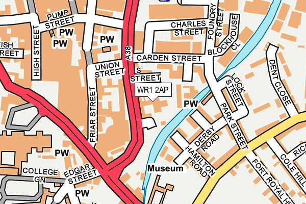
WR1 2AP is located in the Cathedral electoral ward, within the local authority district of Worcester and the English Parliamentary constituency of Worcester. The Sub Integrated Care Board (ICB) Location is NHS Herefordshire and Worcestershire ICB - 18C and the police force is West Mercia. This postcode has been in use since January 1980.


GetTheData
Source: OS OpenMap – Local (Ordnance Survey)
Source: OS VectorMap District (Ordnance Survey)
Licence: Open Government Licence (requires attribution)
| Easting | 385263 |
| Northing | 254598 |
| Latitude | 52.189424 |
| Longitude | -2.216989 |
GetTheData
Source: Open Postcode Geo
Licence: Open Government Licence
| Country | England |
| Postcode District | WR1 |
| ➜ WR1 open data dashboard ➜ See where WR1 is on a map ➜ Where is Worcester? | |
GetTheData
Source: Land Registry Price Paid Data
Licence: Open Government Licence
Elevation or altitude of WR1 2AP as distance above sea level:
| Metres | Feet | |
|---|---|---|
| Elevation | 20m | 66ft |
Elevation is measured from the approximate centre of the postcode, to the nearest point on an OS contour line from OS Terrain 50, which has contour spacing of ten vertical metres.
➜ How high above sea level am I? Find the elevation of your current position using your device's GPS.
GetTheData
Source: Open Postcode Elevation
Licence: Open Government Licence
| Ward | Cathedral |
| Constituency | Worcester |
GetTheData
Source: ONS Postcode Database
Licence: Open Government Licence
| January 2024 | Criminal damage and arson | On or near Parking Area | 264m |
| January 2024 | Anti-social behaviour | On or near Shopping Area | 329m |
| January 2024 | Public order | On or near Shopping Area | 329m |
| ➜ Get more crime data in our Crime section | |||
GetTheData
Source: data.police.uk
Licence: Open Government Licence
| City Walls Road | Worcester | 129m |
| Hamilton Road (Wyld's Lane) | Worcester | 181m |
| Cathedral (Cathedral Square) | Worcester | 214m |
| King's School (King Street) | Worcester | 240m |
| Sidbury (A44) | Worcester | 275m |
| Worcester Foregate Street Station | 0.7km |
| Worcester Shrub Hill Station | 0.8km |
GetTheData
Source: NaPTAN
Licence: Open Government Licence
GetTheData
Source: ONS Postcode Database
Licence: Open Government Licence

➜ Get more ratings from the Food Standards Agency
GetTheData
Source: Food Standards Agency
Licence: FSA terms & conditions
| Last Collection | |||
|---|---|---|---|
| Location | Mon-Fri | Sat | Distance |
| Edgar Street | 18:30 | 11:30 | 230m |
| College Street | 18:30 | 11:30 | 232m |
| High Street | 18:30 | 11:30 | 295m |
GetTheData
Source: Dracos
Licence: Creative Commons Attribution-ShareAlike
| Facility | Distance |
|---|---|
| Fitness4less (Worcester) High Street, Worcester Health and Fitness Gym, Swimming Pool, Studio | 197m |
| The Kings School Worcester College Green, Worcester Sports Hall, Swimming Pool, Health and Fitness Gym | 324m |
| Heart Of Worcestershire College (Worcester Campus) Deansway, Worcester Studio | 361m |
GetTheData
Source: Active Places
Licence: Open Government Licence
| School | Phase of Education | Distance |
|---|---|---|
| The King's School 5, College Green, Worcester, Worcestershire, WR1 2LL | Not applicable | 324m |
| Newbridge School Midland Road, Worcester, WR5 1DS | Not applicable | 466m |
| Stanley Road Primary School Stanley Road, Worcester, WR5 1BD | Primary | 486m |
GetTheData
Source: Edubase
Licence: Open Government Licence
The below table lists the International Territorial Level (ITL) codes (formerly Nomenclature of Territorial Units for Statistics (NUTS) codes) and Local Administrative Units (LAU) codes for WR1 2AP:
| ITL 1 Code | Name |
|---|---|
| TLG | West Midlands (England) |
| ITL 2 Code | Name |
| TLG1 | Herefordshire, Worcestershire and Warwickshire |
| ITL 3 Code | Name |
| TLG12 | Worcestershire CC |
| LAU 1 Code | Name |
| E07000237 | Worcester |
GetTheData
Source: ONS Postcode Directory
Licence: Open Government Licence
The below table lists the Census Output Area (OA), Lower Layer Super Output Area (LSOA), and Middle Layer Super Output Area (MSOA) for WR1 2AP:
| Code | Name | |
|---|---|---|
| OA | E00164701 | |
| LSOA | E01033249 | Worcester 011F |
| MSOA | E02006744 | Worcester 011 |
GetTheData
Source: ONS Postcode Directory
Licence: Open Government Licence
| WR1 2NN | Friar Court | 62m |
| WR1 2AT | Tannery Mews | 74m |
| WR5 1AF | Prince Rupert Road | 100m |
| WR1 2AS | Union Street | 107m |
| WR1 2NA | Friar Street | 110m |
| WR5 1AG | Hamilton Road | 114m |
| WR1 2AH | City Walls Road | 117m |
| WR5 1AE | Derby Road | 133m |
| WR5 1AA | Park Street | 144m |
| WR1 2HT | Sidbury | 146m |
GetTheData
Source: Open Postcode Geo; Land Registry Price Paid Data
Licence: Open Government Licence