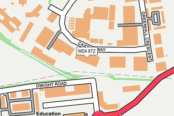
WD4 8TZ is located in the Holywell electoral ward, within the local authority district of Watford and the English Parliamentary constituency of Watford. The Sub Integrated Care Board (ICB) Location is NHS Hertfordshire and West Essex ICB - 06N and the police force is Hertfordshire. This postcode has been in use since August 2007.


GetTheData
Source: OS OpenMap – Local (Ordnance Survey)
Source: OS VectorMap District (Ordnance Survey)
Licence: Open Government Licence (requires attribution)
| Easting | 508882 |
| Northing | 194831 |
| Latitude | 51.641750 |
| Longitude | -0.427895 |
GetTheData
Source: Open Postcode Geo
Licence: Open Government Licence
| Country | England |
| Postcode District | WD4 |
| ➜ WD4 open data dashboard ➜ See where WD4 is on a map ➜ Where is Watford? | |
GetTheData
Source: Land Registry Price Paid Data
Licence: Open Government Licence
Elevation or altitude of WD4 8TZ as distance above sea level:
| Metres | Feet | |
|---|---|---|
| Elevation | 60m | 197ft |
Elevation is measured from the approximate centre of the postcode, to the nearest point on an OS contour line from OS Terrain 50, which has contour spacing of ten vertical metres.
➜ How high above sea level am I? Find the elevation of your current position using your device's GPS.
GetTheData
Source: Open Postcode Elevation
Licence: Open Government Licence
| Ward | Holywell |
| Constituency | Watford |
GetTheData
Source: ONS Postcode Database
Licence: Open Government Licence
| January 2024 | Anti-social behaviour | On or near Greenhill Crescent | 380m |
| October 2023 | Vehicle crime | On or near Greenhill Crescent | 380m |
| September 2023 | Shoplifting | On or near Greenhill Crescent | 380m |
| ➜ Get more crime data in our Crime section | |||
GetTheData
Source: data.police.uk
Licence: Open Government Licence
| Caxton Court (Caxton Way) | Holywell | 30m |
| Magnet (Caxton Way) | Holywell | 247m |
| Watford Enterprise Centre (Greenhill Crescent) | Holywell | 300m |
| Jewson (Caxton Way) | Holywell | 327m |
| Hatters Lane | Holywell | 373m |
| Croxley Underground Station | Croxley Green | 1,123m |
| Moor Park Underground Station | Moor Park | 1,362m |
| Watford High Street Station | 2.8km |
| Bushey Station | 3km |
| Rickmansworth Station | 3.1km |
GetTheData
Source: NaPTAN
Licence: Open Government Licence
GetTheData
Source: ONS Postcode Database
Licence: Open Government Licence


➜ Get more ratings from the Food Standards Agency
GetTheData
Source: Food Standards Agency
Licence: FSA terms & conditions
| Last Collection | |||
|---|---|---|---|
| Location | Mon-Fri | Sat | Distance |
| Dwight Road | 18:30 | 12:00 | 99m |
| Dwight Road | 109m | ||
| Greenhill Crescent | 18:30 | 12:00 | 596m |
GetTheData
Source: Dracos
Licence: Creative Commons Attribution-ShareAlike
| Facility | Distance |
|---|---|
| Pump Gyms (Watford) Wolsey Business Park, Tolpits Lane, Watford Health and Fitness Gym, Studio | 244m |
| Pump Gyms (Watford) (Closed) Greenhill Crescent, Watford Health and Fitness Gym, Studio | 382m |
| Anytime Fitness (Croxley Park) Hatters Lane, Watford Health and Fitness Gym | 469m |
GetTheData
Source: Active Places
Licence: Open Government Licence
| School | Phase of Education | Distance |
|---|---|---|
| Holywell Primary School Tolpits Lane, Watford, WD18 6LL | Primary | 721m |
| St Anthony's Catholic Primary School Croxley View, Watford, WD18 6BW | Primary | 860m |
| Merchant Taylors' School Sandy Lodge, Northwood, Middlesex, Northwood, HA6 2HT | Not applicable | 907m |
GetTheData
Source: Edubase
Licence: Open Government Licence
The below table lists the International Territorial Level (ITL) codes (formerly Nomenclature of Territorial Units for Statistics (NUTS) codes) and Local Administrative Units (LAU) codes for WD4 8TZ:
| ITL 1 Code | Name |
|---|---|
| TLH | East |
| ITL 2 Code | Name |
| TLH2 | Bedfordshire and Hertfordshire |
| ITL 3 Code | Name |
| TLH23 | Hertfordshire CC |
| LAU 1 Code | Name |
| E07000103 | Watford |
GetTheData
Source: ONS Postcode Directory
Licence: Open Government Licence
The below table lists the Census Output Area (OA), Lower Layer Super Output Area (LSOA), and Middle Layer Super Output Area (MSOA) for WD4 8TZ:
| Code | Name | |
|---|---|---|
| OA | E00121191 | |
| LSOA | E01023866 | Watford 011D |
| MSOA | E02004978 | Watford 011 |
GetTheData
Source: ONS Postcode Directory
Licence: Open Government Licence
| WD18 8QZ | Caxton Way | 187m |
| WD18 8JU | Greenhill Crescent | 203m |
| WD18 9DA | Orbital 25 Business Park | 272m |
| WD18 8UA | Caxton Way | 283m |
| WD18 8XN | Greenhill Crescent | 300m |
| WD18 8JA | Greenhill Crescent | 344m |
| WD18 9UD | The Metro Centre | 371m |
| WD18 6PP | Croxley View | 392m |
| WD18 6XL | Latimer Close | 400m |
| WD18 6XE | Marsworth Close | 429m |
GetTheData
Source: Open Postcode Geo; Land Registry Price Paid Data
Licence: Open Government Licence