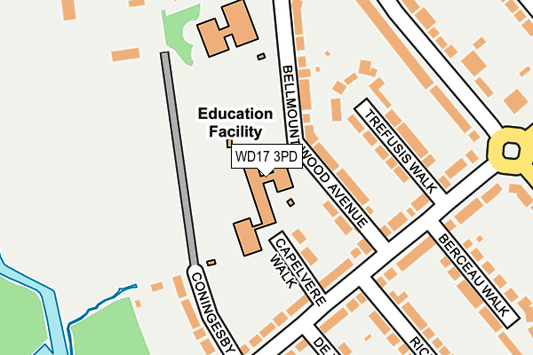
WD17 3PD is located in the Park electoral ward, within the local authority district of Watford and the English Parliamentary constituency of Watford. The Sub Integrated Care Board (ICB) Location is NHS Hertfordshire and West Essex ICB - 06N and the police force is Hertfordshire. This postcode has been in use since December 2000.


GetTheData
Source: OS OpenMap – Local (Ordnance Survey)
Source: OS VectorMap District (Ordnance Survey)
Licence: Open Government Licence (requires attribution)
| Easting | 509222 |
| Northing | 197636 |
| Latitude | 51.666895 |
| Longitude | -0.422109 |
GetTheData
Source: Open Postcode Geo
Licence: Open Government Licence
| Country | England |
| Postcode District | WD17 |
| ➜ WD17 open data dashboard ➜ See where WD17 is on a map ➜ Where is Watford? | |
GetTheData
Source: Land Registry Price Paid Data
Licence: Open Government Licence
Elevation or altitude of WD17 3PD as distance above sea level:
| Metres | Feet | |
|---|---|---|
| Elevation | 60m | 197ft |
Elevation is measured from the approximate centre of the postcode, to the nearest point on an OS contour line from OS Terrain 50, which has contour spacing of ten vertical metres.
➜ How high above sea level am I? Find the elevation of your current position using your device's GPS.
GetTheData
Source: Open Postcode Elevation
Licence: Open Government Licence
| Ward | Park |
| Constituency | Watford |
GetTheData
Source: ONS Postcode Database
Licence: Open Government Licence
| June 2022 | Violence and sexual offences | On or near Capelvere Walk | 111m |
| June 2022 | Public order | On or near Coningesby Drive | 176m |
| June 2022 | Violence and sexual offences | On or near Langley Way | 296m |
| ➜ Get more crime data in our Crime section | |||
GetTheData
Source: data.police.uk
Licence: Open Government Licence
| Langley Way (Cassiobury Drive) | Watford | 313m |
| Hempstead Road (Langley Way) | Watford | 610m |
| Wentworth Close (Hempstead Road) | North Watford | 617m |
| The Gardens (Cassiobury Drive) | Watford | 632m |
| Langley Road (Hempstead Road) | Watford | 695m |
| Watford Underground Station | Watford | 1,101m |
| Watford Junction Station | 1.8km |
| Watford North Station | 2.4km |
| Watford High Street Station | 2.6km |
GetTheData
Source: NaPTAN
Licence: Open Government Licence
GetTheData
Source: ONS Postcode Database
Licence: Open Government Licence


➜ Get more ratings from the Food Standards Agency
GetTheData
Source: Food Standards Agency
Licence: FSA terms & conditions
| Last Collection | |||
|---|---|---|---|
| Location | Mon-Fri | Sat | Distance |
| Cassiobury Park P.o | 17:30 | 12:00 | 309m |
| Vicarage Road | 19:00 | 12:00 | 418m |
| Garden Close | 18:30 | 12:00 | 551m |
GetTheData
Source: Dracos
Licence: Creative Commons Attribution-ShareAlike
| Facility | Distance |
|---|---|
| The New Field (Fullerians Rfc) Coningesby Drive, Coningesby Drive, Watford Grass Pitches | 210m |
| Sun Postal Sports And Social Club Bellmount Wood Avenue, Watford Grass Pitches, Studio | 241m |
| Watford Grammar School For Boys (New Field) Coningesby Drive, Watford Grass Pitches, Artificial Grass Pitch | 294m |
GetTheData
Source: Active Places
Licence: Open Government Licence
| School | Phase of Education | Distance |
|---|---|---|
| Cassiobury Junior School Bellmount Wood Avenue, Watford, WD17 3PD | Primary | 0m |
| Cassiobury Infant and Nursery School Bellmount Wood Avenue, Watford, WD17 3PE | Primary | 176m |
| Nascot Wood Junior School Nascot Wood Road, Watford, WD17 4YS | Primary | 868m |
GetTheData
Source: Edubase
Licence: Open Government Licence
The below table lists the International Territorial Level (ITL) codes (formerly Nomenclature of Territorial Units for Statistics (NUTS) codes) and Local Administrative Units (LAU) codes for WD17 3PD:
| ITL 1 Code | Name |
|---|---|
| TLH | East |
| ITL 2 Code | Name |
| TLH2 | Bedfordshire and Hertfordshire |
| ITL 3 Code | Name |
| TLH23 | Hertfordshire CC |
| LAU 1 Code | Name |
| E07000103 | Watford |
GetTheData
Source: ONS Postcode Directory
Licence: Open Government Licence
The below table lists the Census Output Area (OA), Lower Layer Super Output Area (LSOA), and Middle Layer Super Output Area (MSOA) for WD17 3PD:
| Code | Name | |
|---|---|---|
| OA | E00121303 | |
| LSOA | E01023887 | Watford 008B |
| MSOA | E02004975 | Watford 008 |
GetTheData
Source: ONS Postcode Directory
Licence: Open Government Licence
| WD17 3BN | Bellmount Wood Avenue | 76m |
| WD17 3BW | Bellmount Wood Avenue | 89m |
| WD17 3BJ | Capel Vere Walk | 94m |
| WD17 3EE | Langley Way | 145m |
| WD17 3BP | Trefusis Walk | 155m |
| WD17 3EF | Langley Way | 166m |
| WD17 3FA | Langley Way | 182m |
| WD17 3ED | Langley Way | 192m |
| WD17 3BD | Coningesby Drive | 193m |
| WD17 3AL | Cassiobury Drive | 209m |
GetTheData
Source: Open Postcode Geo; Land Registry Price Paid Data
Licence: Open Government Licence