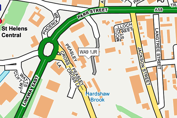
WA9 1JR is located in the Peasley Cross & Fingerpost electoral ward, within the metropolitan district of St. Helens and the English Parliamentary constituency of St Helens South and Whiston. The Sub Integrated Care Board (ICB) Location is NHS Cheshire and Merseyside ICB - 01X and the police force is Merseyside. This postcode has been in use since January 1980.


GetTheData
Source: OS OpenMap – Local (Ordnance Survey)
Source: OS VectorMap District (Ordnance Survey)
Licence: Open Government Licence (requires attribution)
| Easting | 351953 |
| Northing | 395205 |
| Latitude | 53.451417 |
| Longitude | -2.724959 |
GetTheData
Source: Open Postcode Geo
Licence: Open Government Licence
| Country | England |
| Postcode District | WA9 |
| ➜ WA9 open data dashboard ➜ See where WA9 is on a map ➜ Where is St Helens? | |
GetTheData
Source: Land Registry Price Paid Data
Licence: Open Government Licence
Elevation or altitude of WA9 1JR as distance above sea level:
| Metres | Feet | |
|---|---|---|
| Elevation | 30m | 98ft |
Elevation is measured from the approximate centre of the postcode, to the nearest point on an OS contour line from OS Terrain 50, which has contour spacing of ten vertical metres.
➜ How high above sea level am I? Find the elevation of your current position using your device's GPS.
GetTheData
Source: Open Postcode Elevation
Licence: Open Government Licence
| Ward | Peasley Cross & Fingerpost |
| Constituency | St Helens South And Whiston |
GetTheData
Source: ONS Postcode Database
Licence: Open Government Licence
| January 2024 | Violence and sexual offences | On or near Sorogold Street | 336m |
| January 2024 | Violence and sexual offences | On or near Sorogold Street | 336m |
| January 2024 | Violence and sexual offences | On or near Sorogold Street | 336m |
| ➜ Get more crime data in our Crime section | |||
GetTheData
Source: data.police.uk
Licence: Open Government Licence
| Parr Street (Peasley Cross Lane) | Peasley Cross | 86m |
| Mcculloch Street (Jackson Street) | Finger Post | 139m |
| Sorogold Street (Jackson Street) | Finger Post | 152m |
| Phoenix Brow (Corporation Street) | Finger Post | 217m |
| St Helens Retail Park (Peasley Cross Lane) | Peasley Cross | 219m |
| St Helens Central Station | 0.4km |
| St Helens Junction Station | 2.6km |
| Lea Green Station | 2.7km |
GetTheData
Source: NaPTAN
Licence: Open Government Licence
GetTheData
Source: ONS Postcode Database
Licence: Open Government Licence


➜ Get more ratings from the Food Standards Agency
GetTheData
Source: Food Standards Agency
Licence: FSA terms & conditions
| Last Collection | |||
|---|---|---|---|
| Location | Mon-Fri | Sat | Distance |
| Higher Parr Street Post Office | 18:00 | 12:00 | 314m |
| Sorogold Street | 17:00 | 11:00 | 519m |
| Town Hall | 18:00 | 11:00 | 715m |
GetTheData
Source: Dracos
Licence: Creative Commons Attribution-ShareAlike
| Facility | Distance |
|---|---|
| St Helens Rfc (Totally Wicked Stadium) Peasley Cross Lane, St. Helens Grass Pitches | 438m |
| Parr Swimming Pool And Fitness Centre Ashcroft Street, St. Helens Swimming Pool, Health and Fitness Gym | 527m |
| Pyramid Leisure Club Linkway West, St Helens Swimming Pool, Health and Fitness Gym, Studio | 775m |
GetTheData
Source: Active Places
Licence: Open Government Licence
| School | Phase of Education | Distance |
|---|---|---|
| Holy Cross Catholic Primary School Charles Street, St Helens, WA10 1LN | Primary | 666m |
| Parish Church of England Primary School, St Helens Charles Street, St Helens, WA10 1LW | Primary | 736m |
| Merton Bank Primary School Roper Street, St Helens, WA9 1EJ | Primary | 769m |
GetTheData
Source: Edubase
Licence: Open Government Licence
The below table lists the International Territorial Level (ITL) codes (formerly Nomenclature of Territorial Units for Statistics (NUTS) codes) and Local Administrative Units (LAU) codes for WA9 1JR:
| ITL 1 Code | Name |
|---|---|
| TLD | North West (England) |
| ITL 2 Code | Name |
| TLD7 | Merseyside |
| ITL 3 Code | Name |
| TLD71 | East Merseyside |
| LAU 1 Code | Name |
| E08000013 | St. Helens |
GetTheData
Source: ONS Postcode Directory
Licence: Open Government Licence
The below table lists the Census Output Area (OA), Lower Layer Super Output Area (LSOA), and Middle Layer Super Output Area (MSOA) for WA9 1JR:
| Code | Name | |
|---|---|---|
| OA | E00034833 | |
| LSOA | E01006872 | St. Helens 014C |
| MSOA | E02001419 | St. Helens 014 |
GetTheData
Source: ONS Postcode Directory
Licence: Open Government Licence
| WA9 1AR | Langtree Street | 221m |
| WA9 1AZ | South John Street | 254m |
| WA9 1LZ | Ardwick Street | 268m |
| WA9 1AF | Higher Parr Street | 291m |
| WA9 1AD | Higher Parr Street | 303m |
| WA9 1LN | Atlas Street | 317m |
| WA9 1LY | Graham Street | 327m |
| WA9 1NA | Pitt Street | 335m |
| WA9 1BE | Parr Mount Street | 345m |
| WA9 1LW | Vernon Street | 350m |
GetTheData
Source: Open Postcode Geo; Land Registry Price Paid Data
Licence: Open Government Licence