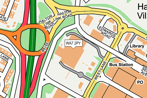
WA7 2PY is located in the Halton Lea electoral ward, within the unitary authority of Halton and the English Parliamentary constituency of Weaver Vale. The Sub Integrated Care Board (ICB) Location is NHS Cheshire and Merseyside ICB - 01F and the police force is Cheshire. This postcode has been in use since July 1990.


GetTheData
Source: OS OpenMap – Local (Ordnance Survey)
Source: OS VectorMap District (Ordnance Survey)
Licence: Open Government Licence (requires attribution)
| Easting | 353395 |
| Northing | 381591 |
| Latitude | 53.329170 |
| Longitude | -2.701233 |
GetTheData
Source: Open Postcode Geo
Licence: Open Government Licence
| Country | England |
| Postcode District | WA7 |
| ➜ WA7 open data dashboard ➜ See where WA7 is on a map ➜ Where is Runcorn? | |
GetTheData
Source: Land Registry Price Paid Data
Licence: Open Government Licence
Elevation or altitude of WA7 2PY as distance above sea level:
| Metres | Feet | |
|---|---|---|
| Elevation | 70m | 230ft |
Elevation is measured from the approximate centre of the postcode, to the nearest point on an OS contour line from OS Terrain 50, which has contour spacing of ten vertical metres.
➜ How high above sea level am I? Find the elevation of your current position using your device's GPS.
GetTheData
Source: Open Postcode Elevation
Licence: Open Government Licence
| Ward | Halton Lea |
| Constituency | Weaver Vale |
GetTheData
Source: ONS Postcode Database
Licence: Open Government Licence
| December 2023 | Other theft | On or near Halton Brook Avenue | 473m |
| October 2023 | Violence and sexual offences | On or near Halton Brook Avenue | 473m |
| July 2023 | Violence and sexual offences | On or near Halton Brook Avenue | 473m |
| ➜ Get more crime data in our Crime section | |||
GetTheData
Source: data.police.uk
Licence: Open Government Licence
| Asda- Halton Lea | Palace Fields | 46m |
| Halton Lea North (Busway) | Palace Fields | 263m |
| Halton Lea South (Busway) | Palace Fields | 304m |
| Hill Lodge Avenue (Busway (Halton Lodge)) | Grange | 353m |
| Hill Lodge Avenue (Busway (Halton Lodge)) | Grange | 357m |
| Runcorn East Station | 2.4km |
| Runcorn Station | 2.7km |
| Frodsham Station | 4km |
GetTheData
Source: NaPTAN
Licence: Open Government Licence
GetTheData
Source: ONS Postcode Database
Licence: Open Government Licence


➜ Get more ratings from the Food Standards Agency
GetTheData
Source: Food Standards Agency
Licence: FSA terms & conditions
| Last Collection | |||
|---|---|---|---|
| Location | Mon-Fri | Sat | Distance |
| Halton Lodge Avenue | 17:30 | 11:00 | 551m |
| Tanhouse | 17:30 | 11:00 | 557m |
| Mount Road | 17:30 | 12:00 | 616m |
GetTheData
Source: Dracos
Licence: Creative Commons Attribution-ShareAlike
| Facility | Distance |
|---|---|
| Active Nation Gym (Runcorn) Trident Park, Halton Lea, Runcorn Health and Fitness Gym, Studio | 200m |
| Woodside County Primary School Whitchurch Way, Halton Lodge, Runcorn Grass Pitches | 515m |
| Castleview Primary School Meadway, Halton Brook, Runcorn Grass Pitches | 566m |
GetTheData
Source: Active Places
Licence: Open Government Licence
| School | Phase of Education | Distance |
|---|---|---|
| Castle View Primary School Mead Way, Halton Brook, Runcorn, WA7 2DZ | Primary | 566m |
| Halton School 31 Main Street, Halton, Runcorn, WA7 2AN | Not applicable | 576m |
| The Holy Spirit Catholic Primary School Cotterill, Halton Brook, Runcorn, WA7 2NL | Primary | 606m |
GetTheData
Source: Edubase
Licence: Open Government Licence
The below table lists the International Territorial Level (ITL) codes (formerly Nomenclature of Territorial Units for Statistics (NUTS) codes) and Local Administrative Units (LAU) codes for WA7 2PY:
| ITL 1 Code | Name |
|---|---|
| TLD | North West (England) |
| ITL 2 Code | Name |
| TLD7 | Merseyside |
| ITL 3 Code | Name |
| TLD71 | East Merseyside |
| LAU 1 Code | Name |
| E06000006 | Halton |
GetTheData
Source: ONS Postcode Directory
Licence: Open Government Licence
The below table lists the Census Output Area (OA), Lower Layer Super Output Area (LSOA), and Middle Layer Super Output Area (MSOA) for WA7 2PY:
| Code | Name | |
|---|---|---|
| OA | E00062587 | |
| LSOA | E01012408 | Halton 013F |
| MSOA | E02002586 | Halton 013 |
GetTheData
Source: ONS Postcode Directory
Licence: Open Government Licence
| WA7 2AR | Lodge Lane | 250m |
| WA7 2PL | Northridge Mews | 280m |
| WA7 2BP | Astmoor Lane | 299m |
| WA7 2AS | Lodge Lane | 327m |
| WA7 2EP | Calvers | 330m |
| WA7 5ND | Cotton Lane | 331m |
| WA7 2EE | Littlegate | 331m |
| WA7 5NE | Cotton Lane | 341m |
| WA7 2SS | Burrard Road | 393m |
| WA7 2AP | Riversdale Road | 393m |
GetTheData
Source: Open Postcode Geo; Land Registry Price Paid Data
Licence: Open Government Licence