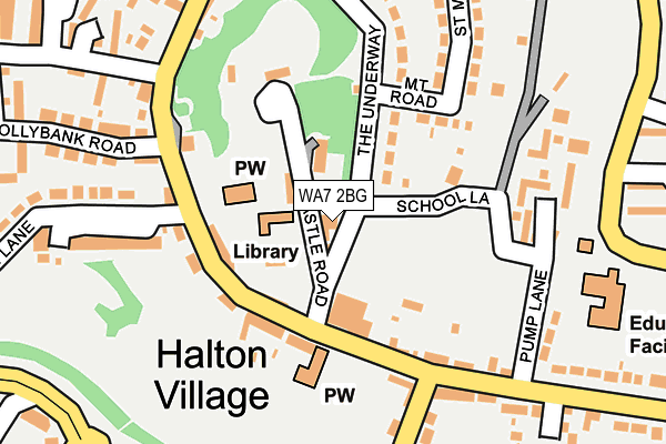
WA7 2BG lies on Castle Road in Halton, Runcorn. WA7 2BG is located in the Halton Castle electoral ward, within the unitary authority of Halton and the English Parliamentary constituency of Halton. The Sub Integrated Care Board (ICB) Location is NHS Cheshire and Merseyside ICB - 01F and the police force is Cheshire. This postcode has been in use since January 1980.


GetTheData
Source: OS OpenMap – Local (Ordnance Survey)
Source: OS VectorMap District (Ordnance Survey)
Licence: Open Government Licence (requires attribution)
| Easting | 353816 |
| Northing | 381883 |
| Latitude | 53.331831 |
| Longitude | -2.694955 |
GetTheData
Source: Open Postcode Geo
Licence: Open Government Licence
| Street | Castle Road |
| Locality | Halton |
| Town/City | Runcorn |
| Country | England |
| Postcode District | WA7 |
| ➜ WA7 open data dashboard ➜ See where WA7 is on a map ➜ Where is Runcorn? | |
GetTheData
Source: Land Registry Price Paid Data
Licence: Open Government Licence
Elevation or altitude of WA7 2BG as distance above sea level:
| Metres | Feet | |
|---|---|---|
| Elevation | 80m | 262ft |
Elevation is measured from the approximate centre of the postcode, to the nearest point on an OS contour line from OS Terrain 50, which has contour spacing of ten vertical metres.
➜ How high above sea level am I? Find the elevation of your current position using your device's GPS.
GetTheData
Source: Open Postcode Elevation
Licence: Open Government Licence
| Ward | Halton Castle |
| Constituency | Halton |
GetTheData
Source: ONS Postcode Database
Licence: Open Government Licence
| December 2023 | Violence and sexual offences | On or near The Croft | 321m |
| November 2023 | Violence and sexual offences | On or near The Croft | 321m |
| November 2023 | Possession of weapons | On or near The Croft | 321m |
| ➜ Castle Road crime map and outcomes | |||
GetTheData
Source: data.police.uk
Licence: Open Government Licence
| British Legion (Main Street) | Halton Village | 103m |
| Lodge Lane (Main Street) | Halton Village | 123m |
| British Legion (Min Street) | Halton Village | 133m |
| Hollybank Road (Main Street) | Halton Village | 155m |
| Pump Lane (Main Street) | Halton Village | 195m |
| Runcorn East Station | 2km |
| Runcorn Station | 3km |
| Frodsham Station | 4.4km |
GetTheData
Source: NaPTAN
Licence: Open Government Licence
| Percentage of properties with Next Generation Access | 100.0% |
| Percentage of properties with Superfast Broadband | 100.0% |
| Percentage of properties with Ultrafast Broadband | 0.0% |
| Percentage of properties with Full Fibre Broadband | 0.0% |
Superfast Broadband is between 30Mbps and 300Mbps
Ultrafast Broadband is > 300Mbps
| Percentage of properties unable to receive 2Mbps | 0.0% |
| Percentage of properties unable to receive 5Mbps | 0.0% |
| Percentage of properties unable to receive 10Mbps | 0.0% |
| Percentage of properties unable to receive 30Mbps | 0.0% |
GetTheData
Source: Ofcom
Licence: Ofcom Terms of Use (requires attribution)
GetTheData
Source: ONS Postcode Database
Licence: Open Government Licence


➜ Get more ratings from the Food Standards Agency
GetTheData
Source: Food Standards Agency
Licence: FSA terms & conditions
| Last Collection | |||
|---|---|---|---|
| Location | Mon-Fri | Sat | Distance |
| Mount Road | 17:30 | 12:00 | 122m |
| Tanhouse | 17:30 | 11:00 | 453m |
| Halton Brow | 17:30 | 11:30 | 644m |
GetTheData
Source: Dracos
Licence: Creative Commons Attribution-ShareAlike
| Facility | Distance |
|---|---|
| St Mary's Church Of England Primary School Castlefields Avenue South, Castlefields, Runcorn Grass Pitches | 256m |
| The Brow Community Primary School The Clough, Halton, Runcorn Grass Pitches | 459m |
| Bridgewater Park Primary School Plantation Close, Castlefields, Runcorn Grass Pitches | 656m |
GetTheData
Source: Active Places
Licence: Open Government Licence
| School | Phase of Education | Distance |
|---|---|---|
| Halton School 31 Main Street, Halton, Runcorn, WA7 2AN | Not applicable | 226m |
| St Mary's Church of England Primary School Castlefields Avenue South, Runcorn, WA7 2NR | Primary | 253m |
| The Brow Community Primary School The Clough, Halton Brow, Runcorn, WA7 2HB | Primary | 376m |
GetTheData
Source: Edubase
Licence: Open Government Licence
The below table lists the International Territorial Level (ITL) codes (formerly Nomenclature of Territorial Units for Statistics (NUTS) codes) and Local Administrative Units (LAU) codes for WA7 2BG:
| ITL 1 Code | Name |
|---|---|
| TLD | North West (England) |
| ITL 2 Code | Name |
| TLD7 | Merseyside |
| ITL 3 Code | Name |
| TLD71 | East Merseyside |
| LAU 1 Code | Name |
| E06000006 | Halton |
GetTheData
Source: ONS Postcode Directory
Licence: Open Government Licence
The below table lists the Census Output Area (OA), Lower Layer Super Output Area (LSOA), and Middle Layer Super Output Area (MSOA) for WA7 2BG:
| Code | Name | |
|---|---|---|
| OA | E00062462 | |
| LSOA | E01012384 | Halton 010C |
| MSOA | E02002583 | Halton 010 |
GetTheData
Source: ONS Postcode Directory
Licence: Open Government Licence
| WA7 2BE | Castle Road | 11m |
| WA7 2AU | Main Street | 97m |
| WA7 2AT | Main Street | 111m |
| WA7 2BH | Mount Road | 135m |
| WA7 2BQ | The Underway | 143m |
| WA7 2AX | Main Street | 169m |
| WA7 2BB | The Common | 192m |
| WA7 2AY | Holt Lane | 196m |
| WA7 2AZ | Main Street | 205m |
| WA7 2BA | Pump Lane | 219m |
GetTheData
Source: Open Postcode Geo; Land Registry Price Paid Data
Licence: Open Government Licence