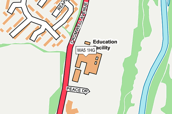
WA5 1HG is located in the Great Sankey South electoral ward, within the unitary authority of Warrington and the English Parliamentary constituency of Warrington South. The Sub Integrated Care Board (ICB) Location is NHS Cheshire and Merseyside ICB - 02E and the police force is Cheshire. This postcode has been in use since January 1983.


GetTheData
Source: OS OpenMap – Local (Ordnance Survey)
Source: OS VectorMap District (Ordnance Survey)
Licence: Open Government Licence (requires attribution)
| Easting | 358816 |
| Northing | 388420 |
| Latitude | 53.391016 |
| Longitude | -2.620734 |
GetTheData
Source: Open Postcode Geo
Licence: Open Government Licence
| Country | England |
| Postcode District | WA5 |
| ➜ WA5 open data dashboard ➜ See where WA5 is on a map ➜ Where is Warrington? | |
GetTheData
Source: Land Registry Price Paid Data
Licence: Open Government Licence
Elevation or altitude of WA5 1HG as distance above sea level:
| Metres | Feet | |
|---|---|---|
| Elevation | 10m | 33ft |
Elevation is measured from the approximate centre of the postcode, to the nearest point on an OS contour line from OS Terrain 50, which has contour spacing of ten vertical metres.
➜ How high above sea level am I? Find the elevation of your current position using your device's GPS.
GetTheData
Source: Open Postcode Elevation
Licence: Open Government Licence
| Ward | Great Sankey South |
| Constituency | Warrington South |
GetTheData
Source: ONS Postcode Database
Licence: Open Government Licence
| January 2024 | Violence and sexual offences | On or near Percy Street | 491m |
| January 2024 | Violence and sexual offences | On or near Percy Street | 491m |
| January 2024 | Violence and sexual offences | On or near Percy Street | 491m |
| ➜ Get more crime data in our Crime section | |||
GetTheData
Source: data.police.uk
Licence: Open Government Licence
| St Gregorys School (Cromwell Avenue) | Sankey Bridges | 68m |
| St Gregorys School (Cromwell Avenue) | Sankey Bridges | 76m |
| St Gregory's High School (Peace Drive) | Sankey Bridges | 126m |
| Payne Close (Canons Road) | Old Hall | 329m |
| Payne Close (Canons Road) | Old Hall | 389m |
| Warrington Bank Quay Station | 1.3km |
| Warrington Central Station | 1.8km |
| Sankey for Penketh Station | 2km |
GetTheData
Source: NaPTAN
Licence: Open Government Licence
GetTheData
Source: ONS Postcode Database
Licence: Open Government Licence


➜ Get more ratings from the Food Standards Agency
GetTheData
Source: Food Standards Agency
Licence: FSA terms & conditions
| Last Collection | |||
|---|---|---|---|
| Location | Mon-Fri | Sat | Distance |
| Hood Manor S.o. | 17:15 | 12:00 | 494m |
| Borough General Hospital | 17:30 | 11:00 | 746m |
| Sycamore Lane | 17:30 | 10:30 | 748m |
GetTheData
Source: Dracos
Licence: Creative Commons Attribution-ShareAlike
| Facility | Distance |
|---|---|
| St Gregorys Catholic High School Cromwell Avenue, Great Sankey, Warrington Health and Fitness Gym, Grass Pitches, Sports Hall, Studio, Outdoor Tennis Courts | 0m |
| Hood Lane Recreation Ground Hood Lane North, Great Sankey, Warrington Grass Pitches | 394m |
| David Lloyd (Warrington) Cromwell Avenue South, Great Sankey, Warrington Sports Hall, Swimming Pool, Health and Fitness Gym, Indoor Tennis Centre, Studio, Squash Courts, Outdoor Tennis Courts | 456m |
GetTheData
Source: Active Places
Licence: Open Government Licence
| School | Phase of Education | Distance |
|---|---|---|
| St Gregory's Catholic High School Cromwell Avenue, Great Sankey, Warrington, WA5 1HG | Secondary | 15m |
| Sacred Heart Catholic Primary School Selby Street, Warrington, WA5 1NS | Primary | 444m |
| Sankey Valley St James Church of England Primary School Dorchester Road, Great Sankey, Warrington, WA5 1XE | Primary | 623m |
GetTheData
Source: Edubase
Licence: Open Government Licence
The below table lists the International Territorial Level (ITL) codes (formerly Nomenclature of Territorial Units for Statistics (NUTS) codes) and Local Administrative Units (LAU) codes for WA5 1HG:
| ITL 1 Code | Name |
|---|---|
| TLD | North West (England) |
| ITL 2 Code | Name |
| TLD6 | Cheshire |
| ITL 3 Code | Name |
| TLD61 | Warrington |
| LAU 1 Code | Name |
| E06000007 | Warrington |
GetTheData
Source: ONS Postcode Directory
Licence: Open Government Licence
The below table lists the Census Output Area (OA), Lower Layer Super Output Area (LSOA), and Middle Layer Super Output Area (MSOA) for WA5 1HG:
| Code | Name | |
|---|---|---|
| OA | E00063027 | |
| LSOA | E01012497 | Warrington 016C |
| MSOA | E02002605 | Warrington 016 |
GetTheData
Source: ONS Postcode Directory
Licence: Open Government Licence
| WA5 1DT | Payne Close | 174m |
| WA5 1DX | Reaper Close | 215m |
| WA5 1DY | Reaper Close | 251m |
| WA5 1DU | Payne Close | 300m |
| WA5 1EZ | Thurston Close | 347m |
| WA5 1ET | Hood Lane North | 361m |
| WA5 1PA | Kimberley Street | 362m |
| WA5 1HJ | Grange Farm Close | 378m |
| WA5 1NY | Fox Street | 407m |
| WA5 1PD | Delamere Street | 413m |
GetTheData
Source: Open Postcode Geo; Land Registry Price Paid Data
Licence: Open Government Licence