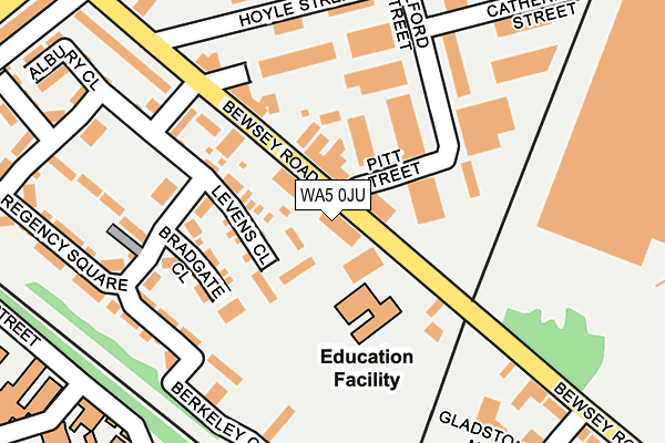
WA5 0JU is located in the Bewsey and Whitecross electoral ward, within the unitary authority of Warrington and the English Parliamentary constituency of Warrington South. The Sub Integrated Care Board (ICB) Location is NHS Cheshire and Merseyside ICB - 02E and the police force is Cheshire. This postcode has been in use since June 2001.


GetTheData
Source: OS OpenMap – Local (Ordnance Survey)
Source: OS VectorMap District (Ordnance Survey)
Licence: Open Government Licence (requires attribution)
| Easting | 359906 |
| Northing | 388957 |
| Latitude | 53.395927 |
| Longitude | -2.604413 |
GetTheData
Source: Open Postcode Geo
Licence: Open Government Licence
| Country | England |
| Postcode District | WA5 |
| ➜ WA5 open data dashboard ➜ See where WA5 is on a map ➜ Where is Warrington? | |
GetTheData
Source: Land Registry Price Paid Data
Licence: Open Government Licence
Elevation or altitude of WA5 0JU as distance above sea level:
| Metres | Feet | |
|---|---|---|
| Elevation | 10m | 33ft |
Elevation is measured from the approximate centre of the postcode, to the nearest point on an OS contour line from OS Terrain 50, which has contour spacing of ten vertical metres.
➜ How high above sea level am I? Find the elevation of your current position using your device's GPS.
GetTheData
Source: Open Postcode Elevation
Licence: Open Government Licence
| Ward | Bewsey And Whitecross |
| Constituency | Warrington South |
GetTheData
Source: ONS Postcode Database
Licence: Open Government Licence
| January 2024 | Violence and sexual offences | On or near Regency Square | 249m |
| January 2024 | Violence and sexual offences | On or near Hospital | 472m |
| January 2024 | Violence and sexual offences | On or near Hospital | 472m |
| ➜ Get more crime data in our Crime section | |||
GetTheData
Source: data.police.uk
Licence: Open Government Licence
| Medical Centre (Folly Lane) | Bewsey | 316m |
| Medical Centre (Folly Lane) | Bewsey | 333m |
| Bewsey Road (Lovely Lane) | Bewsey | 337m |
| Tyrol House (Folly Lane) | Bewsey | 348m |
| Clapgates (Lovely Lane) | Bewsey | 367m |
| Warrington Central Station | 0.9km |
| Warrington Bank Quay Station | 1.1km |
| Sankey for Penketh Station | 3.1km |
GetTheData
Source: NaPTAN
Licence: Open Government Licence
GetTheData
Source: ONS Postcode Database
Licence: Open Government Licence


➜ Get more ratings from the Food Standards Agency
GetTheData
Source: Food Standards Agency
Licence: FSA terms & conditions
| Last Collection | |||
|---|---|---|---|
| Location | Mon-Fri | Sat | Distance |
| Bewsey Road | 17:30 | 11:00 | 397m |
| Borough General Hospital | 17:30 | 11:00 | 480m |
| Milner Street D O | 18:30 | 13:45 | 705m |
GetTheData
Source: Dracos
Licence: Creative Commons Attribution-ShareAlike
| Facility | Distance |
|---|---|
| St Alban's Catholic Primary School Bewsey Road, Warrington Grass Pitches, Sports Hall | 84m |
| St Barnabas Ce Primary School Collin Street, Warrington Grass Pitches | 573m |
| Warrington Wolves (Halliwell Jones Stadium) Winwick Road, Warrington Grass Pitches | 599m |
GetTheData
Source: Active Places
Licence: Open Government Licence
| School | Phase of Education | Distance |
|---|---|---|
| St Alban's Catholic Primary School Bewsey Road, Warrington, WA5 0JS | Primary | 83m |
| Warrington Hospital Unit Co Wards B10-11 Lovely Lane, Warrington NHS Trust Hospital, Warrington, WA5 1QG | Not applicable | 472m |
| Bewsey Lodge Primary School Lodge Lane, Bewsey, Warrington, WA5 0AG | Primary | 481m |
GetTheData
Source: Edubase
Licence: Open Government Licence
The below table lists the International Territorial Level (ITL) codes (formerly Nomenclature of Territorial Units for Statistics (NUTS) codes) and Local Administrative Units (LAU) codes for WA5 0JU:
| ITL 1 Code | Name |
|---|---|
| TLD | North West (England) |
| ITL 2 Code | Name |
| TLD6 | Cheshire |
| ITL 3 Code | Name |
| TLD61 | Warrington |
| LAU 1 Code | Name |
| E06000007 | Warrington |
GetTheData
Source: ONS Postcode Directory
Licence: Open Government Licence
The below table lists the Census Output Area (OA), Lower Layer Super Output Area (LSOA), and Middle Layer Super Output Area (MSOA) for WA5 0JU:
| Code | Name | |
|---|---|---|
| OA | E00173148 | |
| LSOA | E01033302 | Warrington 018G |
| MSOA | E02002607 | Warrington 018 |
GetTheData
Source: ONS Postcode Directory
Licence: Open Government Licence
| WA5 0JT | Bewsey Road | 40m |
| WA5 0EU | Levens Close | 60m |
| WA5 0JS | Bewsey Road | 129m |
| WA5 0ET | Bradgate Close | 130m |
| WA5 0LG | Bewsey Road | 138m |
| WA5 0EP | Berkeley Close | 169m |
| WA5 0EB | Regency Square | 179m |
| WA5 0LH | Catherine Street | 194m |
| WA5 0JH | Bewsey Road | 218m |
| WA5 0LR | Hoyle Street | 218m |
GetTheData
Source: Open Postcode Geo; Land Registry Price Paid Data
Licence: Open Government Licence