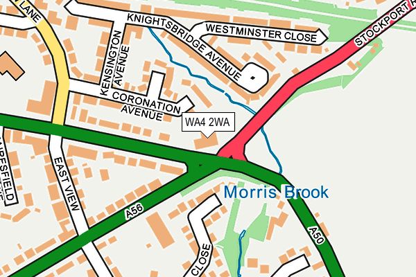
WA4 2WA is located in the Lymm North and Thelwall electoral ward, within the unitary authority of Warrington and the English Parliamentary constituency of Warrington South. The Sub Integrated Care Board (ICB) Location is NHS Cheshire and Merseyside ICB - 02E and the police force is Cheshire. This postcode has been in use since June 1996.


GetTheData
Source: OS OpenMap – Local (Ordnance Survey)
Source: OS VectorMap District (Ordnance Survey)
Licence: Open Government Licence (requires attribution)
| Easting | 364210 |
| Northing | 386829 |
| Latitude | 53.377094 |
| Longitude | -2.539450 |
GetTheData
Source: Open Postcode Geo
Licence: Open Government Licence
| Country | England |
| Postcode District | WA4 |
| ➜ WA4 open data dashboard ➜ See where WA4 is on a map ➜ Where is Warrington? | |
GetTheData
Source: Land Registry Price Paid Data
Licence: Open Government Licence
Elevation or altitude of WA4 2WA as distance above sea level:
| Metres | Feet | |
|---|---|---|
| Elevation | 20m | 66ft |
Elevation is measured from the approximate centre of the postcode, to the nearest point on an OS contour line from OS Terrain 50, which has contour spacing of ten vertical metres.
➜ How high above sea level am I? Find the elevation of your current position using your device's GPS.
GetTheData
Source: Open Postcode Elevation
Licence: Open Government Licence
| Ward | Lymm North And Thelwall |
| Constituency | Warrington South |
GetTheData
Source: ONS Postcode Database
Licence: Open Government Licence
| August 2023 | Anti-social behaviour | On or near Menlow Close | 406m |
| August 2022 | Anti-social behaviour | On or near Menlow Close | 406m |
| June 2022 | Anti-social behaviour | On or near East View | 217m |
| ➜ Get more crime data in our Crime section | |||
GetTheData
Source: data.police.uk
Licence: Open Government Licence
| Shadewood Crescent (Lindi Avenue) | Grappenhall | 245m |
| Dog & Dart (Knutsford Road) | Grappenhall | 258m |
| East View (Chester Road) | Grappenhall | 260m |
| East View (Chester Road) | Grappenhall | 280m |
| British Legion (Stockport Road) | Thelwall | 333m |
| Padgate Station | 3.4km |
| Warrington Central Station | 3.9km |
| Birchwood Station | 4.1km |
GetTheData
Source: NaPTAN
Licence: Open Government Licence
GetTheData
Source: ONS Postcode Database
Licence: Open Government Licence


➜ Get more ratings from the Food Standards Agency
GetTheData
Source: Food Standards Agency
Licence: FSA terms & conditions
| Last Collection | |||
|---|---|---|---|
| Location | Mon-Fri | Sat | Distance |
| Bradshaw Lane | 17:30 | 11:00 | 204m |
| Grappenhall So | 17:30 | 12:00 | 328m |
| Community Centre | 17:30 | 11:00 | 440m |
GetTheData
Source: Dracos
Licence: Creative Commons Attribution-ShareAlike
| Facility | Distance |
|---|---|
| Bradshaw Community Primary School Bradshaw Lane, Bradshaw Lane, Grappenhall, Warrington Grass Pitches | 303m |
| Euclid Avenue Playing Field Euclid Avenue, Grappenhall, Warrington Grass Pitches | 446m |
| Grappenhall Youth And Community Centre Bellhouse Lane, Grappenhall, Warrington Sports Hall | 468m |
GetTheData
Source: Active Places
Licence: Open Government Licence
| School | Phase of Education | Distance |
|---|---|---|
| Bradshaw Community Primary School Bradshaw Lane, Grappenhall, Warrington, WA4 2QN | Primary | 322m |
| Thelwall Infant School Thelwall Infant School, Pelham Road, Thelwall, Warrington, WA4 2HF | Primary | 471m |
| Grappenhall St Wilfrid's CofE Primary School Church Lane, Grappenhall, Warrington, WA4 3EP | Primary | 663m |
GetTheData
Source: Edubase
Licence: Open Government Licence
The below table lists the International Territorial Level (ITL) codes (formerly Nomenclature of Territorial Units for Statistics (NUTS) codes) and Local Administrative Units (LAU) codes for WA4 2WA:
| ITL 1 Code | Name |
|---|---|
| TLD | North West (England) |
| ITL 2 Code | Name |
| TLD6 | Cheshire |
| ITL 3 Code | Name |
| TLD61 | Warrington |
| LAU 1 Code | Name |
| E06000007 | Warrington |
GetTheData
Source: ONS Postcode Directory
Licence: Open Government Licence
The below table lists the Census Output Area (OA), Lower Layer Super Output Area (LSOA), and Middle Layer Super Output Area (MSOA) for WA4 2WA:
| Code | Name | |
|---|---|---|
| OA | E00062999 | |
| LSOA | E01012487 | Warrington 022C |
| MSOA | E02002611 | Warrington 022 |
GetTheData
Source: ONS Postcode Directory
Licence: Open Government Licence
| WA4 2QT | Ascot Close | 69m |
| WA4 2QW | Coronation Avenue | 121m |
| WA4 2QJ | Knutsford Road | 127m |
| WA4 2QL | Knutsford Road | 140m |
| WA4 2QR | Knightsbridge Avenue | 141m |
| WA4 2QQ | Chester Road | 144m |
| WA4 2TY | Knutsford Road | 156m |
| WA4 2UA | Stockport Road | 157m |
| WA4 2QP | Kensington Avenue | 171m |
| WA4 2QS | Westminster Close | 183m |
GetTheData
Source: Open Postcode Geo; Land Registry Price Paid Data
Licence: Open Government Licence