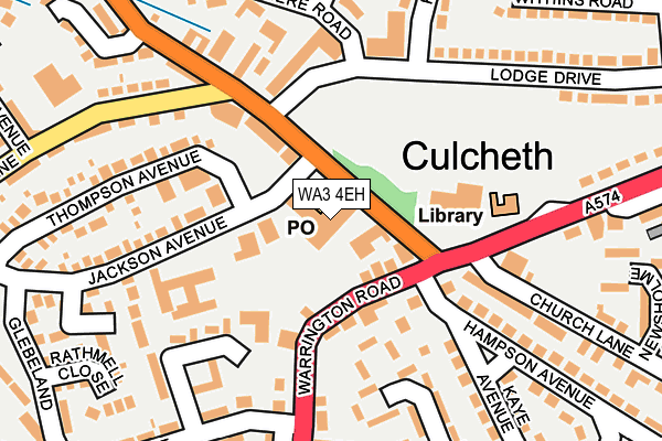
WA3 4EH is located in the Culcheth, Glazebury and Croft electoral ward, within the unitary authority of Warrington and the English Parliamentary constituency of Warrington North. The Sub Integrated Care Board (ICB) Location is NHS Cheshire and Merseyside ICB - 02E and the police force is Cheshire. This postcode has been in use since January 1980.


GetTheData
Source: OS OpenMap – Local (Ordnance Survey)
Source: OS VectorMap District (Ordnance Survey)
Licence: Open Government Licence (requires attribution)
| Easting | 365508 |
| Northing | 395196 |
| Latitude | 53.452385 |
| Longitude | -2.520858 |
GetTheData
Source: Open Postcode Geo
Licence: Open Government Licence
| Country | England |
| Postcode District | WA3 |
| ➜ WA3 open data dashboard ➜ See where WA3 is on a map ➜ Where is Culcheth? | |
GetTheData
Source: Land Registry Price Paid Data
Licence: Open Government Licence
Elevation or altitude of WA3 4EH as distance above sea level:
| Metres | Feet | |
|---|---|---|
| Elevation | 30m | 98ft |
Elevation is measured from the approximate centre of the postcode, to the nearest point on an OS contour line from OS Terrain 50, which has contour spacing of ten vertical metres.
➜ How high above sea level am I? Find the elevation of your current position using your device's GPS.
GetTheData
Source: Open Postcode Elevation
Licence: Open Government Licence
| Ward | Culcheth, Glazebury And Croft |
| Constituency | Warrington North |
GetTheData
Source: ONS Postcode Database
Licence: Open Government Licence
| December 2023 | Criminal damage and arson | On or near Wirral Close | 361m |
| October 2023 | Violence and sexual offences | On or near Wirral Close | 361m |
| September 2023 | Other theft | On or near Wirral Close | 361m |
| ➜ Get more crime data in our Crime section | |||
GetTheData
Source: data.police.uk
Licence: Open Government Licence
| Cps Centre (Common Lane) | Culcheth | 31m |
| Cps Centre (Common Lane) | Culcheth | 40m |
| The Cherry Tree (Common Lane) | Culcheth | 174m |
| Library (Warrington Road) | Culcheth | 192m |
| The Cherry Tree (Common Lane) | Culcheth | 213m |
| Birchwood Station | 4.4km |
| Glazebrook Station | 4.9km |
GetTheData
Source: NaPTAN
Licence: Open Government Licence
GetTheData
Source: ONS Postcode Database
Licence: Open Government Licence


➜ Get more ratings from the Food Standards Agency
GetTheData
Source: Food Standards Agency
Licence: FSA terms & conditions
| Last Collection | |||
|---|---|---|---|
| Location | Mon-Fri | Sat | Distance |
| Culcheth S.o. | 17:30 | 12:00 | 40m |
| Lodge Drive | 16:15 | 11:00 | 149m |
| Kaye Avenue | 17:00 | 08:30 | 303m |
GetTheData
Source: Dracos
Licence: Creative Commons Attribution-ShareAlike
| Facility | Distance |
|---|---|
| Newchurch Community Primary School Glebeland, Culcheth, Warrington Sports Hall, Grass Pitches | 350m |
| Culcheth Sports Club Charnock Road, Culcheth, Warrington Grass Pitches, Sports Hall, Outdoor Tennis Courts | 399m |
| Shaw Street Recreation Ground Shaw Street, Culcheth And Glazebury, Warrington Grass Pitches | 654m |
GetTheData
Source: Active Places
Licence: Open Government Licence
| School | Phase of Education | Distance |
|---|---|---|
| Newchurch Community Primary School Glebeland, Culcheth, Warrington, WA3 4DX | Primary | 346m |
| Twiss Green Community Primary School Twiss Green Lane, Culcheth, Warrington, WA3 4DQ | Primary | 684m |
| Culcheth High School Warrington Road, Culcheth, Warrington, WA3 5HH | Secondary | 697m |
GetTheData
Source: Edubase
Licence: Open Government Licence
The below table lists the International Territorial Level (ITL) codes (formerly Nomenclature of Territorial Units for Statistics (NUTS) codes) and Local Administrative Units (LAU) codes for WA3 4EH:
| ITL 1 Code | Name |
|---|---|
| TLD | North West (England) |
| ITL 2 Code | Name |
| TLD6 | Cheshire |
| ITL 3 Code | Name |
| TLD61 | Warrington |
| LAU 1 Code | Name |
| E06000007 | Warrington |
GetTheData
Source: ONS Postcode Directory
Licence: Open Government Licence
The below table lists the Census Output Area (OA), Lower Layer Super Output Area (LSOA), and Middle Layer Super Output Area (MSOA) for WA3 4EH:
| Code | Name | |
|---|---|---|
| OA | E00062913 | |
| LSOA | E01012474 | Warrington 002B |
| MSOA | E02002591 | Warrington 002 |
GetTheData
Source: ONS Postcode Directory
Licence: Open Government Licence
| WA3 5QX | Warrington Road | 60m |
| WA3 4EW | Common Lane | 86m |
| WA3 5QU | Warrington Road | 96m |
| WA3 4GB | Ellesmere Road | 168m |
| WA3 5QY | Warrington Road | 175m |
| WA3 5QZ | Warrington Road | 176m |
| WA3 4EL | Jackson Avenue | 197m |
| WA3 4BP | Ellesmere Road | 199m |
| WA3 5RG | Poplar Avenue | 201m |
| WA3 4EB | Thompson Avenue | 202m |
GetTheData
Source: Open Postcode Geo; Land Registry Price Paid Data
Licence: Open Government Licence