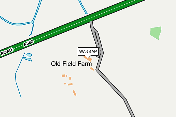
WA3 4AP is located in the Culcheth, Glazebury and Croft electoral ward, within the unitary authority of Warrington and the English Parliamentary constituency of Warrington North. The Sub Integrated Care Board (ICB) Location is NHS Cheshire and Merseyside ICB - 02E and the police force is Cheshire. This postcode has been in use since January 1980.


GetTheData
Source: OS OpenMap – Local (Ordnance Survey)
Source: OS VectorMap District (Ordnance Survey)
Licence: Open Government Licence (requires attribution)
| Easting | 366137 |
| Northing | 397876 |
| Latitude | 53.476514 |
| Longitude | -2.511677 |
GetTheData
Source: Open Postcode Geo
Licence: Open Government Licence
| Country | England |
| Postcode District | WA3 |
| ➜ WA3 open data dashboard ➜ See where WA3 is on a map | |
GetTheData
Source: Land Registry Price Paid Data
Licence: Open Government Licence
Elevation or altitude of WA3 4AP as distance above sea level:
| Metres | Feet | |
|---|---|---|
| Elevation | 20m | 66ft |
Elevation is measured from the approximate centre of the postcode, to the nearest point on an OS contour line from OS Terrain 50, which has contour spacing of ten vertical metres.
➜ How high above sea level am I? Find the elevation of your current position using your device's GPS.
GetTheData
Source: Open Postcode Elevation
Licence: Open Government Licence
| Ward | Culcheth, Glazebury And Croft |
| Constituency | Warrington North |
GetTheData
Source: ONS Postcode Database
Licence: Open Government Licence
| Chestnut Dr Sth/Wigshaw Cl (Chestnut Dr Sth) | Landside | 764m |
| Chesnut Dr Sth/Landside (Chesnut Dr Sth) | Landside | 846m |
| Landside/Chestnut Drive (E Bound) (Landside) | Landside | 887m |
| Foresters Arms (Warrington Road) | Glazebury | 897m |
| Warrington Rd/East Lancs Rd (Warrington Rd) | Siddow Common | 898m |
GetTheData
Source: NaPTAN
Licence: Open Government Licence
| Percentage of properties with Next Generation Access | 100.0% |
| Percentage of properties with Superfast Broadband | 100.0% |
| Percentage of properties with Ultrafast Broadband | 0.0% |
| Percentage of properties with Full Fibre Broadband | 0.0% |
Superfast Broadband is between 30Mbps and 300Mbps
Ultrafast Broadband is > 300Mbps
| Percentage of properties unable to receive 2Mbps | 0.0% |
| Percentage of properties unable to receive 5Mbps | 0.0% |
| Percentage of properties unable to receive 10Mbps | 0.0% |
| Percentage of properties unable to receive 30Mbps | 0.0% |
GetTheData
Source: Ofcom
Licence: Ofcom Terms of Use (requires attribution)
GetTheData
Source: ONS Postcode Database
Licence: Open Government Licence


➜ Get more ratings from the Food Standards Agency
GetTheData
Source: Food Standards Agency
Licence: FSA terms & conditions
| Last Collection | |||
|---|---|---|---|
| Location | Mon-Fri | Sat | Distance |
| Hurst Mill Avenue | 17:30 | 09:00 | 1,071m |
| Glazebury S.o. | 17:30 | 12:00 | 1,299m |
| 2 Bonneywell Road | 18:15 | 12:00 | 1,620m |
GetTheData
Source: Dracos
Licence: Creative Commons Attribution-ShareAlike
| Facility | Distance |
|---|---|
| Round Ash Park Hand Lane, Leigh Grass Pitches | 783m |
| The Escape Zone (Leigh) Warrington Road, Leigh Health and Fitness Gym, Swimming Pool | 830m |
| Leigh Cricket Club Beech Walk, Leigh Grass Pitches, Outdoor Tennis Courts | 1.1km |
GetTheData
Source: Active Places
Licence: Open Government Licence
| School | Phase of Education | Distance |
|---|---|---|
| Glazebury Church of England Primary School Warrington Road, Glazebury, Warrington, WA3 5LZ | Primary | 1.2km |
| Bedford Hall Methodist Primary School Breaston Avenue, Leigh, WN7 3DJ | Primary | 1.5km |
| Gilded Hollins Community School St Helen's Road, Leigh, WN7 3PQ | Primary | 1.8km |
GetTheData
Source: Edubase
Licence: Open Government Licence
The below table lists the International Territorial Level (ITL) codes (formerly Nomenclature of Territorial Units for Statistics (NUTS) codes) and Local Administrative Units (LAU) codes for WA3 4AP:
| ITL 1 Code | Name |
|---|---|
| TLD | North West (England) |
| ITL 2 Code | Name |
| TLD6 | Cheshire |
| ITL 3 Code | Name |
| TLD61 | Warrington |
| LAU 1 Code | Name |
| E06000007 | Warrington |
GetTheData
Source: ONS Postcode Directory
Licence: Open Government Licence
The below table lists the Census Output Area (OA), Lower Layer Super Output Area (LSOA), and Middle Layer Super Output Area (MSOA) for WA3 4AP:
| Code | Name | |
|---|---|---|
| OA | E00062923 | |
| LSOA | E01012476 | Warrington 001C |
| MSOA | E02002590 | Warrington 001 |
GetTheData
Source: ONS Postcode Directory
Licence: Open Government Licence
| WN7 3QZ | Meadow Beck | 506m |
| WN7 3NL | Thames Avenue | 520m |
| WN7 3RA | Beck Field Close | 569m |
| WN7 3NN | Alwyn Close | 598m |
| WN7 3NJ | Townson Drive | 640m |
| WN7 3RU | Landside Croft | 654m |
| WN7 3JZ | Wigshaw Close | 655m |
| WA3 4AW | East Lancashire Road | 670m |
| WN7 3NG | Thames Avenue | 742m |
| WN7 3JY | Chestnut Drive South | 744m |
GetTheData
Source: Open Postcode Geo; Land Registry Price Paid Data
Licence: Open Government Licence