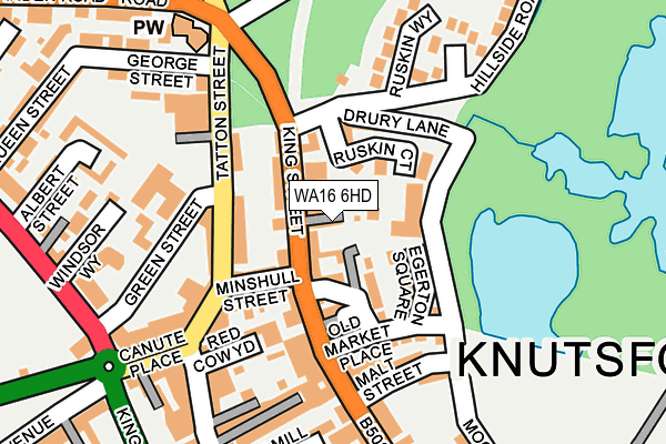
WA16 6HD is located in the Knutsford electoral ward, within the unitary authority of Cheshire East and the English Parliamentary constituency of Tatton. The Sub Integrated Care Board (ICB) Location is NHS Cheshire and Merseyside ICB - 27D and the police force is Cheshire. This postcode has been in use since January 1980.


GetTheData
Source: OS OpenMap – Local (Ordnance Survey)
Source: OS VectorMap District (Ordnance Survey)
Licence: Open Government Licence (requires attribution)
| Easting | 375203 |
| Northing | 378852 |
| Latitude | 53.306042 |
| Longitude | -2.373582 |
GetTheData
Source: Open Postcode Geo
Licence: Open Government Licence
| Country | England |
| Postcode District | WA16 |
| ➜ WA16 open data dashboard ➜ See where WA16 is on a map ➜ Where is Knutsford? | |
GetTheData
Source: Land Registry Price Paid Data
Licence: Open Government Licence
Elevation or altitude of WA16 6HD as distance above sea level:
| Metres | Feet | |
|---|---|---|
| Elevation | 50m | 164ft |
Elevation is measured from the approximate centre of the postcode, to the nearest point on an OS contour line from OS Terrain 50, which has contour spacing of ten vertical metres.
➜ How high above sea level am I? Find the elevation of your current position using your device's GPS.
GetTheData
Source: Open Postcode Elevation
Licence: Open Government Licence
| Ward | Knutsford |
| Constituency | Tatton |
GetTheData
Source: ONS Postcode Database
Licence: Open Government Licence
| January 2024 | Shoplifting | On or near Parking Area | 253m |
| January 2024 | Shoplifting | On or near Parking Area | 253m |
| January 2024 | Shoplifting | On or near Parking Area | 458m |
| ➜ Get more crime data in our Crime section | |||
GetTheData
Source: data.police.uk
Licence: Open Government Licence
| Canute Place | Knutsford | 170m |
| Queen Street (Manchester Road) | Knutsford | 308m |
| Queen Street (Manchester Road) | Knutsford | 348m |
| Church Hill (King Edward Road) | Knutsford | 369m |
| Railway Station (Adams Hill) | Knutsford | 502m |
| Knutsford Station | 0.5km |
| Mobberley Station | 3.7km |
| Plumley Station | 4.6km |
GetTheData
Source: NaPTAN
Licence: Open Government Licence
| Percentage of properties with Next Generation Access | 100.0% |
| Percentage of properties with Superfast Broadband | 100.0% |
| Percentage of properties with Ultrafast Broadband | 100.0% |
| Percentage of properties with Full Fibre Broadband | 0.0% |
Superfast Broadband is between 30Mbps and 300Mbps
Ultrafast Broadband is > 300Mbps
| Percentage of properties unable to receive 2Mbps | 0.0% |
| Percentage of properties unable to receive 5Mbps | 0.0% |
| Percentage of properties unable to receive 10Mbps | 0.0% |
| Percentage of properties unable to receive 30Mbps | 0.0% |
GetTheData
Source: Ofcom
Licence: Ofcom Terms of Use (requires attribution)
GetTheData
Source: ONS Postcode Database
Licence: Open Government Licence


➜ Get more ratings from the Food Standards Agency
GetTheData
Source: Food Standards Agency
Licence: FSA terms & conditions
| Last Collection | |||
|---|---|---|---|
| Location | Mon-Fri | Sat | Distance |
| King Street | 17:30 | 11:00 | 31m |
| Canute Square | 18:15 | 11:00 | 215m |
| 41a King Street | 17:30 | 11:00 | 299m |
GetTheData
Source: Dracos
Licence: Creative Commons Attribution-ShareAlike
| Facility | Distance |
|---|---|
| Anytime Fitness (Knutsford) Canute Place, Tatton Street, Knutsford Health and Fitness Gym | 136m |
| Knutsford Golf Club Mereheath Lane, Knutsford Golf | 252m |
| Knutsford Sports Club Mereheath Lane, Knutsford Grass Pitches, Squash Courts, Outdoor Tennis Courts | 653m |
GetTheData
Source: Active Places
Licence: Open Government Licence
| School | Phase of Education | Distance |
|---|---|---|
| Egerton Primary School Bexton Road, Egerton Primary School, Knutsford, WA16 0EE | Primary | 364m |
| Cheshire Studio School Bexton Road, Knutsford, WA16 0EA | Secondary | 764m |
| Knutsford Academy Bexton Road, Knutsford, WA16 0EA | Secondary | 764m |
GetTheData
Source: Edubase
Licence: Open Government Licence
The below table lists the International Territorial Level (ITL) codes (formerly Nomenclature of Territorial Units for Statistics (NUTS) codes) and Local Administrative Units (LAU) codes for WA16 6HD:
| ITL 1 Code | Name |
|---|---|
| TLD | North West (England) |
| ITL 2 Code | Name |
| TLD6 | Cheshire |
| ITL 3 Code | Name |
| TLD62 | Cheshire East |
| LAU 1 Code | Name |
| E06000049 | Cheshire East |
GetTheData
Source: ONS Postcode Directory
Licence: Open Government Licence
The below table lists the Census Output Area (OA), Lower Layer Super Output Area (LSOA), and Middle Layer Super Output Area (MSOA) for WA16 6HD:
| Code | Name | |
|---|---|---|
| OA | E00093898 | |
| LSOA | E01018605 | Cheshire East 009A |
| MSOA | E02003861 | Cheshire East 009 |
GetTheData
Source: ONS Postcode Directory
Licence: Open Government Licence
| WA16 6HW | King Street | 61m |
| WA16 6HN | Ruskin Court | 62m |
| WA16 6HE | Ruskin Court | 72m |
| WA16 6EY | Egerton Square | 76m |
| WA16 6HX | King Street | 77m |
| WA16 6HF | King Street | 82m |
| WA16 6EN | Tatton Street | 88m |
| WA16 6HG | Minshull Street | 91m |
| WA16 6HA | Drury Lane | 93m |
| WA16 6AE | Tatton Street | 103m |
GetTheData
Source: Open Postcode Geo; Land Registry Price Paid Data
Licence: Open Government Licence