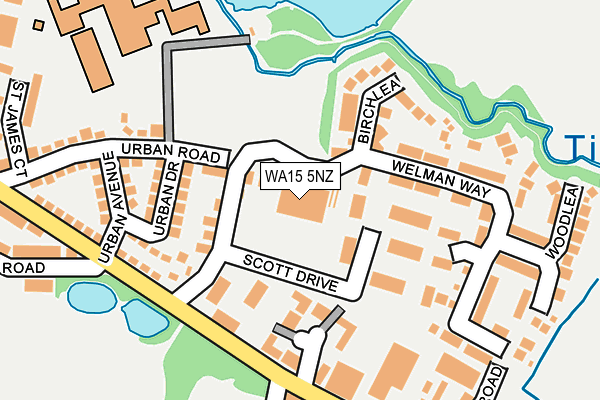
WA15 5NZ is located in the Altrincham electoral ward, within the metropolitan district of Trafford and the English Parliamentary constituency of Altrincham and Sale West. The Sub Integrated Care Board (ICB) Location is NHS Greater Manchester ICB - 02A and the police force is Greater Manchester. This postcode has been in use since January 2016.


GetTheData
Source: OS OpenMap – Local (Ordnance Survey)
Source: OS VectorMap District (Ordnance Survey)
Licence: Open Government Licence (requires attribution)
| Easting | 377583 |
| Northing | 387715 |
| Latitude | 53.385798 |
| Longitude | -2.338499 |
GetTheData
Source: Open Postcode Geo
Licence: Open Government Licence
| Country | England |
| Postcode District | WA15 |
| ➜ WA15 open data dashboard ➜ See where WA15 is on a map ➜ Where is Altrincham? | |
GetTheData
Source: Land Registry Price Paid Data
Licence: Open Government Licence
Elevation or altitude of WA15 5NZ as distance above sea level:
| Metres | Feet | |
|---|---|---|
| Elevation | 30m | 98ft |
Elevation is measured from the approximate centre of the postcode, to the nearest point on an OS contour line from OS Terrain 50, which has contour spacing of ten vertical metres.
➜ How high above sea level am I? Find the elevation of your current position using your device's GPS.
GetTheData
Source: Open Postcode Elevation
Licence: Open Government Licence
| Ward | Altrincham |
| Constituency | Altrincham And Sale West |
GetTheData
Source: ONS Postcode Database
Licence: Open Government Licence
| February 2021 | Anti-social behaviour | On or near Urban Avenue | 183m |
| ➜ Get more crime data in our Crime section | |||
GetTheData
Source: data.police.uk
Licence: Open Government Licence
| Moss Lane/Urban Avenue (Moss Lane) | Altrincham | 188m |
| Urban Rd/Blessed Thomas Holford (Urban Road) | Altrincham | 212m |
| Moss Lane/Urban Avenue (Moss Lane) | Altrincham | 229m |
| Moss Lane/Football Ground (Moss Lane) | Hale | 273m |
| Stamford Park Road/Football Ground (Stamford Pk Rd) | Hale | 310m |
| Altrincham (Manchester Metrolink) (Stamford New Road) | Altrincham | 612m |
| Navigation Road (Manchester Metrolink) (Navigation Road) | Navigation Road | 1,098m |
| Altrincham Station | 0.6km |
| Hale Station | 1km |
| Navigation Road Station | 1.1km |
GetTheData
Source: NaPTAN
Licence: Open Government Licence
GetTheData
Source: ONS Postcode Database
Licence: Open Government Licence


➜ Get more ratings from the Food Standards Agency
GetTheData
Source: Food Standards Agency
Licence: FSA terms & conditions
| Last Collection | |||
|---|---|---|---|
| Location | Mon-Fri | Sat | Distance |
| Delivery Office | 18:30 | 57m | |
| Delivery Office | 18:30 | 12:00 | 62m |
| Moss Lane | 17:30 | 11:00 | 299m |
GetTheData
Source: Dracos
Licence: Creative Commons Attribution-ShareAlike
| Facility | Distance |
|---|---|
| Blessed Thomas Holford Catholic College Urban Road, Altrincham Artificial Grass Pitch, Health and Fitness Gym, Grass Pitches, Sports Hall, Outdoor Tennis Courts | 263m |
| Stamford Park Stamford Park Road, Altrincham Grass Pitches, Outdoor Tennis Courts | 305m |
| Moss Lane Moss Lane, Hale, Altrincham Grass Pitches, Sports Hall | 383m |
GetTheData
Source: Active Places
Licence: Open Government Licence
| School | Phase of Education | Distance |
|---|---|---|
| Blessed Thomas Holford Catholic College Urban Road, Altrincham, WA15 8HT | Secondary | 249m |
| Stamford Park Primary School Cedar Road, Hale, Altrincham, WA15 9JB | Primary | 402m |
| St Vincent's Catholic Primary School Orchard Road, Altrincham, WA15 8EY | Primary | 521m |
GetTheData
Source: Edubase
Licence: Open Government Licence
The below table lists the International Territorial Level (ITL) codes (formerly Nomenclature of Territorial Units for Statistics (NUTS) codes) and Local Administrative Units (LAU) codes for WA15 5NZ:
| ITL 1 Code | Name |
|---|---|
| TLD | North West (England) |
| ITL 2 Code | Name |
| TLD3 | Greater Manchester |
| ITL 3 Code | Name |
| TLD34 | Greater Manchester South West |
| LAU 1 Code | Name |
| E08000009 | Trafford |
GetTheData
Source: ONS Postcode Directory
Licence: Open Government Licence
The below table lists the Census Output Area (OA), Lower Layer Super Output Area (LSOA), and Middle Layer Super Output Area (MSOA) for WA15 5NZ:
| Code | Name | |
|---|---|---|
| OA | E00168591 | |
| LSOA | E01006194 | Trafford 024E |
| MSOA | E02001282 | Trafford 024 |
GetTheData
Source: ONS Postcode Directory
Licence: Open Government Licence
| WA15 8WF | Birchlea | 120m |
| WA15 8EG | New Copper Moss | 122m |
| WA15 8WE | Welman Way | 127m |
| WA15 8WD | Welman Way | 135m |
| WA15 8HX | Urban Drive | 147m |
| WA15 8WN | Elmlea | 156m |
| WA15 8HS | Urban Avenue | 199m |
| WA15 8HT | Urban Road | 208m |
| WA15 8HR | Moss Lane | 213m |
| WA15 8WG | Pinelea | 238m |
GetTheData
Source: Open Postcode Geo; Land Registry Price Paid Data
Licence: Open Government Licence