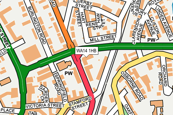
WA14 1HB lies on Barrington Road in Altrincham. WA14 1HB is located in the Altrincham electoral ward, within the metropolitan district of Trafford and the English Parliamentary constituency of Altrincham and Sale West. The Sub Integrated Care Board (ICB) Location is NHS Greater Manchester ICB - 02A and the police force is Greater Manchester. This postcode has been in use since September 2008.


GetTheData
Source: OS OpenMap – Local (Ordnance Survey)
Source: OS VectorMap District (Ordnance Survey)
Licence: Open Government Licence (requires attribution)
| Easting | 377026 |
| Northing | 388278 |
| Latitude | 53.390834 |
| Longitude | -2.346914 |
GetTheData
Source: Open Postcode Geo
Licence: Open Government Licence
| Street | Barrington Road |
| Town/City | Altrincham |
| Country | England |
| Postcode District | WA14 |
| ➜ WA14 open data dashboard ➜ See where WA14 is on a map ➜ Where is Altrincham? | |
GetTheData
Source: Land Registry Price Paid Data
Licence: Open Government Licence
Elevation or altitude of WA14 1HB as distance above sea level:
| Metres | Feet | |
|---|---|---|
| Elevation | 30m | 98ft |
Elevation is measured from the approximate centre of the postcode, to the nearest point on an OS contour line from OS Terrain 50, which has contour spacing of ten vertical metres.
➜ How high above sea level am I? Find the elevation of your current position using your device's GPS.
GetTheData
Source: Open Postcode Elevation
Licence: Open Government Licence
| Ward | Altrincham |
| Constituency | Altrincham And Sale West |
GetTheData
Source: ONS Postcode Database
Licence: Open Government Licence
| Barrington Road/Stamford Street (Barrington Road) | Altrincham | 103m |
| Barrington Road/Hazel Road (Barrington Road) | Altrincham | 162m |
| Woodlands Road/Cresta Court Hotel (Woodlands Road) | Altrincham | 168m |
| Woodlands Road/Cresta Court Hotel (Woodlands Road) | Altrincham | 182m |
| Stamford New Road/Station House (Stamford New Rd) | Altrincham | 203m |
| Altrincham (Manchester Metrolink) (Stamford New Road) | Altrincham | 318m |
| Navigation Road (Manchester Metrolink) (Navigation Road) | Navigation Road | 543m |
| Timperley (Manchester Metrolink) (Park Road) | Timperley | 1,561m |
| Altrincham Station | 0.3km |
| Navigation Road Station | 0.6km |
| Hale Station | 1.3km |
GetTheData
Source: NaPTAN
Licence: Open Government Licence
GetTheData
Source: ONS Postcode Database
Licence: Open Government Licence


➜ Get more ratings from the Food Standards Agency
GetTheData
Source: Food Standards Agency
Licence: FSA terms & conditions
| Last Collection | |||
|---|---|---|---|
| Location | Mon-Fri | Sat | Distance |
| Springfield Road | 17:30 | 11:00 | 170m |
| Derby Street | 17:30 | 11:00 | 176m |
| Ambassador Place | 18:30 | 11:00 | 188m |
GetTheData
Source: Dracos
Licence: Creative Commons Attribution-ShareAlike
| Facility | Distance |
|---|---|
| Altrincham Leisure Centre Oakfield Road, Altrincham Sports Hall, Swimming Pool, Health and Fitness Gym, Squash Courts, Studio | 302m |
| Puregym (Altrincham) Stamford New Road, Altrincham Health and Fitness Gym | 314m |
| A S E Club High Bank, Altrincham Sports Hall | 384m |
GetTheData
Source: Active Places
Licence: Open Government Licence
| School | Phase of Education | Distance |
|---|---|---|
| St Vincent's Catholic Primary School Orchard Road, Altrincham, WA15 8EY | Primary | 333m |
| Altrincham CofE (Aided) Primary School Townfield Road, Altrincham, WA14 4DS | Primary | 427m |
| Blessed Thomas Holford Catholic College Urban Road, Altrincham, WA15 8HT | Secondary | 544m |
GetTheData
Source: Edubase
Licence: Open Government Licence
The below table lists the International Territorial Level (ITL) codes (formerly Nomenclature of Territorial Units for Statistics (NUTS) codes) and Local Administrative Units (LAU) codes for WA14 1HB:
| ITL 1 Code | Name |
|---|---|
| TLD | North West (England) |
| ITL 2 Code | Name |
| TLD3 | Greater Manchester |
| ITL 3 Code | Name |
| TLD34 | Greater Manchester South West |
| LAU 1 Code | Name |
| E08000009 | Trafford |
GetTheData
Source: ONS Postcode Directory
Licence: Open Government Licence
The below table lists the Census Output Area (OA), Lower Layer Super Output Area (LSOA), and Middle Layer Super Output Area (MSOA) for WA14 1HB:
| Code | Name | |
|---|---|---|
| OA | E00030772 | |
| LSOA | E01006080 | Trafford 024B |
| MSOA | E02001282 | Trafford 024 |
GetTheData
Source: ONS Postcode Directory
Licence: Open Government Licence
| WA14 1LA | Grosvenor Road | 66m |
| WA14 1HJ | Barrington Road | 75m |
| WA14 1HG | Woodlands Road | 90m |
| WA14 1JP | Renshaw Street | 111m |
| WA14 1HE | Springfield Road | 115m |
| WA14 1JX | Airedale Court | 119m |
| WA14 1JW | Hart Street | 125m |
| WA15 8DB | Ambassador Place | 131m |
| WA15 8ET | Stockport Road | 142m |
| WA14 1JU | Matlock Mews | 150m |
GetTheData
Source: Open Postcode Geo; Land Registry Price Paid Data
Licence: Open Government Licence