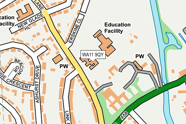
WA11 9QY is located in the Blackbrook electoral ward, within the metropolitan district of St. Helens and the English Parliamentary constituency of St Helens North. The Sub Integrated Care Board (ICB) Location is NHS Cheshire and Merseyside ICB - 01X and the police force is Merseyside. This postcode has been in use since January 1980.


GetTheData
Source: OS OpenMap – Local (Ordnance Survey)
Source: OS VectorMap District (Ordnance Survey)
Licence: Open Government Licence (requires attribution)
| Easting | 353229 |
| Northing | 396635 |
| Latitude | 53.464369 |
| Longitude | -2.705960 |
GetTheData
Source: Open Postcode Geo
Licence: Open Government Licence
| Country | England |
| Postcode District | WA11 |
| ➜ WA11 open data dashboard ➜ See where WA11 is on a map ➜ Where is St Helens? | |
GetTheData
Source: Land Registry Price Paid Data
Licence: Open Government Licence
Elevation or altitude of WA11 9QY as distance above sea level:
| Metres | Feet | |
|---|---|---|
| Elevation | 30m | 98ft |
Elevation is measured from the approximate centre of the postcode, to the nearest point on an OS contour line from OS Terrain 50, which has contour spacing of ten vertical metres.
➜ How high above sea level am I? Find the elevation of your current position using your device's GPS.
GetTheData
Source: Open Postcode Elevation
Licence: Open Government Licence
| Ward | Blackbrook |
| Constituency | St Helens North |
GetTheData
Source: ONS Postcode Database
Licence: Open Government Licence
| June 2022 | Criminal damage and arson | On or near Erskine Close | 116m |
| June 2022 | Violence and sexual offences | On or near Erskine Close | 116m |
| June 2022 | Drugs | On or near Erskine Close | 116m |
| ➜ Get more crime data in our Crime section | |||
GetTheData
Source: data.police.uk
Licence: Open Government Licence
| Rufford Walk (Chain Lane) | Blackbrook | 150m |
| Paisley Avenue (Chain Lane) | Blackbrook | 190m |
| O' Sullivan Crescent (Blackbrook Road) | Blackbrook | 208m |
| Billinge Crescent (Ashurst Drive) | Blackbrook | 223m |
| Ashurst Drive | Blackbrook | 238m |
| St Helens Central Station | 2km |
| St Helens Junction Station | 3.4km |
| Garswood Station | 3.5km |
GetTheData
Source: NaPTAN
Licence: Open Government Licence
GetTheData
Source: ONS Postcode Database
Licence: Open Government Licence


➜ Get more ratings from the Food Standards Agency
GetTheData
Source: Food Standards Agency
Licence: FSA terms & conditions
| Last Collection | |||
|---|---|---|---|
| Location | Mon-Fri | Sat | Distance |
| Blackbrook Road Post Office | 17:00 | 11:00 | 270m |
| Central Av/ St Helens Road | 17:30 | 12:00 | 709m |
| Edward Street | 17:00 | 11:00 | 960m |
GetTheData
Source: Dracos
Licence: Creative Commons Attribution-ShareAlike
| Facility | Distance |
|---|---|
| Ashurst Primary School New Glade Hill, St. Helens Grass Pitches | 267m |
| Blackbrook Mcdonald Ave Playing Fields O'sullivan Crescent, St. Helens Grass Pitches | 558m |
| St Augustine Of Canterbury Catholic High School Boardmans Lane, St. Helens Sports Hall, Grass Pitches, Artificial Grass Pitch | 587m |
GetTheData
Source: Active Places
Licence: Open Government Licence
| School | Phase of Education | Distance |
|---|---|---|
| St. Mary's Catholic Primary Blackbrook Chain Lane, Blackbrook, St Helens, WA11 9QY | Primary | 0m |
| Ashurst Primary School New Glade Hill, Off Chain Lane, Blackbrook, St Helens, WA11 9QJ | Primary | 266m |
| St Augustine of Canterbury Catholic Academy Boardmans Lane, Blackbrook, St. Helens, WA11 9BB | Secondary | 587m |
GetTheData
Source: Edubase
Licence: Open Government Licence
The below table lists the International Territorial Level (ITL) codes (formerly Nomenclature of Territorial Units for Statistics (NUTS) codes) and Local Administrative Units (LAU) codes for WA11 9QY:
| ITL 1 Code | Name |
|---|---|
| TLD | North West (England) |
| ITL 2 Code | Name |
| TLD7 | Merseyside |
| ITL 3 Code | Name |
| TLD71 | East Merseyside |
| LAU 1 Code | Name |
| E08000013 | St. Helens |
GetTheData
Source: ONS Postcode Directory
Licence: Open Government Licence
The below table lists the Census Output Area (OA), Lower Layer Super Output Area (LSOA), and Middle Layer Super Output Area (MSOA) for WA11 9QY:
| Code | Name | |
|---|---|---|
| OA | E00034542 | |
| LSOA | E01006815 | St. Helens 008F |
| MSOA | E02001413 | St. Helens 008 |
GetTheData
Source: ONS Postcode Directory
Licence: Open Government Licence
| WA11 9QE | Chain Lane | 76m |
| WA11 9QQ | Erskine Close | 130m |
| WA11 9QZ | Chain Lane | 134m |
| WA11 9QF | Chain Lane | 161m |
| WA11 9DN | Ashurst Close | 162m |
| WA11 9QD | Link Avenue | 170m |
| WA11 9DJ | Ashurst Drive | 221m |
| WA11 9RN | Renfrew Avenue | 222m |
| WA11 9DH | Beacon Grove | 232m |
| WA11 9QN | Paisley Avenue | 237m |
GetTheData
Source: Open Postcode Geo; Land Registry Price Paid Data
Licence: Open Government Licence