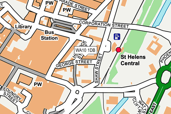
WA10 1DB is located in the St Helens Town Centre electoral ward, within the metropolitan district of St. Helens and the English Parliamentary constituency of St Helens South and Whiston. The Sub Integrated Care Board (ICB) Location is NHS Cheshire and Merseyside ICB - 01X and the police force is Merseyside. This postcode has been in use since January 1980.


GetTheData
Source: OS OpenMap – Local (Ordnance Survey)
Source: OS VectorMap District (Ordnance Survey)
Licence: Open Government Licence (requires attribution)
| Easting | 351504 |
| Northing | 395314 |
| Latitude | 53.452340 |
| Longitude | -2.731737 |
GetTheData
Source: Open Postcode Geo
Licence: Open Government Licence
| Country | England |
| Postcode District | WA10 |
| ➜ WA10 open data dashboard ➜ See where WA10 is on a map ➜ Where is St Helens? | |
GetTheData
Source: Land Registry Price Paid Data
Licence: Open Government Licence
Elevation or altitude of WA10 1DB as distance above sea level:
| Metres | Feet | |
|---|---|---|
| Elevation | 30m | 98ft |
Elevation is measured from the approximate centre of the postcode, to the nearest point on an OS contour line from OS Terrain 50, which has contour spacing of ten vertical metres.
➜ How high above sea level am I? Find the elevation of your current position using your device's GPS.
GetTheData
Source: Open Postcode Elevation
Licence: Open Government Licence
| Ward | St Helens Town Centre |
| Constituency | St Helens South And Whiston |
GetTheData
Source: ONS Postcode Database
Licence: Open Government Licence
| January 2024 | Anti-social behaviour | On or near Theatre/Concert Hall | 215m |
| January 2024 | Anti-social behaviour | On or near Theatre/Concert Hall | 215m |
| January 2024 | Burglary | On or near Theatre/Concert Hall | 215m |
| ➜ Get more crime data in our Crime section | |||
GetTheData
Source: data.police.uk
Licence: Open Government Licence
| St Helens Central Station (Shaw Street) | St Helens | 55m |
| George Street (Hall Street) | St Helens | 76m |
| Hall Street | St Helens | 89m |
| Bickerstaffe Street | St Helens | 106m |
| Bickerstaffe Street | St Helens | 115m |
| St Helens Central Station | 0.1km |
| Thatto Heath Station | 2.5km |
| Lea Green Station | 2.9km |
GetTheData
Source: NaPTAN
Licence: Open Government Licence
GetTheData
Source: ONS Postcode Database
Licence: Open Government Licence


➜ Get more ratings from the Food Standards Agency
GetTheData
Source: Food Standards Agency
Licence: FSA terms & conditions
| Last Collection | |||
|---|---|---|---|
| Location | Mon-Fri | Sat | Distance |
| Town Hall | 18:00 | 11:00 | 275m |
| Bridge Street Post Office | 18:00 | 12:30 | 481m |
| Lincoln House | 17:30 | 11:00 | 547m |
GetTheData
Source: Dracos
Licence: Creative Commons Attribution-ShareAlike
| Facility | Distance |
|---|---|
| Pyramid Leisure Club Linkway West, St Helens Swimming Pool, Health and Fitness Gym, Studio | 409m |
| Ymca St Helens (The Beacon) College Street, St Helens Sports Hall, Health and Fitness Gym, Studio | 592m |
| Central Fitness (Closed) Duke Street, St. Helens Health and Fitness Gym, Squash Courts | 630m |
GetTheData
Source: Active Places
Licence: Open Government Licence
| School | Phase of Education | Distance |
|---|---|---|
| Holy Cross Catholic Primary School Charles Street, St Helens, WA10 1LN | Primary | 370m |
| Parish Church of England Primary School, St Helens Charles Street, St Helens, WA10 1LW | Primary | 508m |
| Launchpad Centre College Street, St Helens, WA10 1UH | Not applicable | 611m |
GetTheData
Source: Edubase
Licence: Open Government Licence
The below table lists the International Territorial Level (ITL) codes (formerly Nomenclature of Territorial Units for Statistics (NUTS) codes) and Local Administrative Units (LAU) codes for WA10 1DB:
| ITL 1 Code | Name |
|---|---|
| TLD | North West (England) |
| ITL 2 Code | Name |
| TLD7 | Merseyside |
| ITL 3 Code | Name |
| TLD71 | East Merseyside |
| LAU 1 Code | Name |
| E08000013 | St. Helens |
GetTheData
Source: ONS Postcode Directory
Licence: Open Government Licence
The below table lists the Census Output Area (OA), Lower Layer Super Output Area (LSOA), and Middle Layer Super Output Area (MSOA) for WA10 1DB:
| Code | Name | |
|---|---|---|
| OA | E00034851 | |
| LSOA | E01006872 | St. Helens 014C |
| MSOA | E02001419 | St. Helens 014 |
GetTheData
Source: ONS Postcode Directory
Licence: Open Government Licence
| WA10 1DD | Haydock Street | 30m |
| WA10 1DF | Shaw Street | 37m |
| WA10 1DL | Hall Street | 61m |
| WA10 1BU | George Street | 68m |
| WA10 1DH | Bickerstaffe Street | 76m |
| WA10 1DJ | Hall Street | 107m |
| WA10 1AJ | Church Street | 111m |
| WA10 1EQ | Corporation Street | 157m |
| WA10 1DS | Bickerstaffe Street | 187m |
| WA10 1ED | Corporation Street | 195m |
GetTheData
Source: Open Postcode Geo; Land Registry Price Paid Data
Licence: Open Government Licence