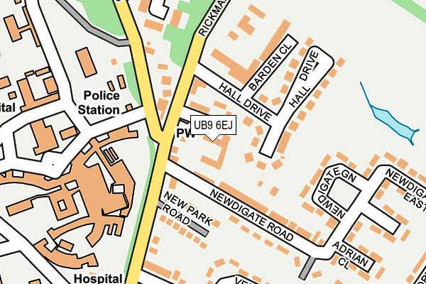
UB9 6EJ is located in the Harefield Village electoral ward, within the London borough of Hillingdon and the English Parliamentary constituency of Ruislip, Northwood and Pinner. The Sub Integrated Care Board (ICB) Location is NHS North West London ICB - W2U3Z and the police force is Metropolitan Police. This postcode has been in use since January 1980.


GetTheData
Source: OS OpenMap – Local (Ordnance Survey)
Source: OS VectorMap District (Ordnance Survey)
Licence: Open Government Licence (requires attribution)
| Easting | 505387 |
| Northing | 190911 |
| Latitude | 51.607182 |
| Longitude | -0.479562 |
GetTheData
Source: Open Postcode Geo
Licence: Open Government Licence
| Country | England |
| Postcode District | UB9 |
| ➜ UB9 open data dashboard ➜ See where UB9 is on a map ➜ Where is Harefield? | |
GetTheData
Source: Land Registry Price Paid Data
Licence: Open Government Licence
Elevation or altitude of UB9 6EJ as distance above sea level:
| Metres | Feet | |
|---|---|---|
| Elevation | 80m | 262ft |
Elevation is measured from the approximate centre of the postcode, to the nearest point on an OS contour line from OS Terrain 50, which has contour spacing of ten vertical metres.
➜ How high above sea level am I? Find the elevation of your current position using your device's GPS.
GetTheData
Source: Open Postcode Elevation
Licence: Open Government Licence
| Ward | Harefield Village |
| Constituency | Ruislip, Northwood And Pinner |
GetTheData
Source: ONS Postcode Database
Licence: Open Government Licence
| June 2022 | Anti-social behaviour | On or near Chapel Row | 44m |
| June 2022 | Vehicle crime | On or near New Park Road | 114m |
| June 2022 | Anti-social behaviour | On or near New Park Road | 114m |
| ➜ Get more crime data in our Crime section | |||
GetTheData
Source: data.police.uk
Licence: Open Government Licence
| Harefield Hospital | Harefield | 165m |
| New Park Road (Rickmansworth Road) | Harefield | 170m |
| New Park Road (Rickmansworth Road) | Harefield | 259m |
| Mossendew Close (Northwood Road) | Harefield | 342m |
| Wickham Close (Northwood Road) | Harefield | 343m |
| Denham Station | 3.4km |
| Rickmansworth Station | 3.7km |
| Denham Golf Club Station | 4km |
GetTheData
Source: NaPTAN
Licence: Open Government Licence
GetTheData
Source: ONS Postcode Database
Licence: Open Government Licence


➜ Get more ratings from the Food Standards Agency
GetTheData
Source: Food Standards Agency
Licence: FSA terms & conditions
| Last Collection | |||
|---|---|---|---|
| Location | Mon-Fri | Sat | Distance |
| Rickmansworth Road | 17:15 | 13:00 | 164m |
| Harefield Post Office | 18:45 | 12:25 | 386m |
| High Street | 17:15 | 12:25 | 551m |
GetTheData
Source: Dracos
Licence: Creative Commons Attribution-ShareAlike
| Facility | Distance |
|---|---|
| Taylors Meadow Rickmansworth Road, Harefield, Uxbridge Grass Pitches, Outdoor Tennis Courts | 388m |
| G & G's (Closed) High Street, Harefield, Uxbridge Health and Fitness Gym | 415m |
| Harefield Junior School Park Lane, Harefield, Uxbridge Grass Pitches | 441m |
GetTheData
Source: Active Places
Licence: Open Government Licence
| School | Phase of Education | Distance |
|---|---|---|
| Harefield School Northwood Way, Harefield, Uxbridge, UB9 6ET | Secondary | 449m |
| Harefield Junior School Park Lane, Harefield, UB9 6BJ | Primary | 456m |
| Harefield Infant School High Street, Harefield, UB9 6BT | Primary | 498m |
GetTheData
Source: Edubase
Licence: Open Government Licence
The below table lists the International Territorial Level (ITL) codes (formerly Nomenclature of Territorial Units for Statistics (NUTS) codes) and Local Administrative Units (LAU) codes for UB9 6EJ:
| ITL 1 Code | Name |
|---|---|
| TLI | London |
| ITL 2 Code | Name |
| TLI7 | Outer London - West and North West |
| ITL 3 Code | Name |
| TLI74 | Harrow and Hillingdon |
| LAU 1 Code | Name |
| E09000017 | Hillingdon |
GetTheData
Source: ONS Postcode Directory
Licence: Open Government Licence
The below table lists the Census Output Area (OA), Lower Layer Super Output Area (LSOA), and Middle Layer Super Output Area (MSOA) for UB9 6EJ:
| Code | Name | |
|---|---|---|
| OA | E00012168 | |
| LSOA | E01002439 | Hillingdon 003B |
| MSOA | E02000496 | Hillingdon 003 |
GetTheData
Source: ONS Postcode Directory
Licence: Open Government Licence
| UB9 6JZ | Chapel Row | 46m |
| UB9 6JX | Rickmansworth Road | 49m |
| UB9 6EH | Newdigate Road | 78m |
| UB9 6LA | Hall Drive | 108m |
| UB9 6EQ | New Park Road | 133m |
| UB9 6JY | Rickmansworth Road | 152m |
| UB9 6EP | Newdigate Green | 153m |
| UB9 6LW | Barden Close | 155m |
| UB9 6JT | Rickmansworth Road | 160m |
| UB9 6EL | Newdigate Road | 165m |
GetTheData
Source: Open Postcode Geo; Land Registry Price Paid Data
Licence: Open Government Licence