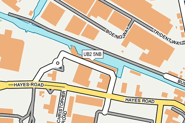
UB2 5NB is located in the Heston West electoral ward, within the London borough of Hounslow and the English Parliamentary constituency of Feltham and Heston. The Sub Integrated Care Board (ICB) Location is NHS North West London ICB - W2U3Z and the police force is Metropolitan Police. This postcode has been in use since January 1980.


GetTheData
Source: OS OpenMap – Local (Ordnance Survey)
Source: OS VectorMap District (Ordnance Survey)
Licence: Open Government Licence (requires attribution)
| Easting | 510890 |
| Northing | 178958 |
| Latitude | 51.498694 |
| Longitude | -0.403893 |
GetTheData
Source: Open Postcode Geo
Licence: Open Government Licence
| Country | England |
| Postcode District | UB2 |
| ➜ UB2 open data dashboard ➜ See where UB2 is on a map ➜ Where is London? | |
GetTheData
Source: Land Registry Price Paid Data
Licence: Open Government Licence
Elevation or altitude of UB2 5NB as distance above sea level:
| Metres | Feet | |
|---|---|---|
| Elevation | 30m | 98ft |
Elevation is measured from the approximate centre of the postcode, to the nearest point on an OS contour line from OS Terrain 50, which has contour spacing of ten vertical metres.
➜ How high above sea level am I? Find the elevation of your current position using your device's GPS.
GetTheData
Source: Open Postcode Elevation
Licence: Open Government Licence
| Ward | Heston West |
| Constituency | Feltham And Heston |
GetTheData
Source: ONS Postcode Database
Licence: Open Government Licence
| June 2022 | Anti-social behaviour | On or near Shopping Area | 87m |
| June 2022 | Other theft | On or near Shopping Area | 87m |
| June 2022 | Vehicle crime | On or near Bus/Coach Station | 95m |
| ➜ Get more crime data in our Crime section | |||
GetTheData
Source: data.police.uk
Licence: Open Government Licence
| Hayes Road Tesco | Cranford | 105m |
| Hayes Road Tesco | Cranford | 136m |
| Bulls Bridge Tesco | Cranford | 142m |
| Navigator Park (Southall Lane) | Cranford | 267m |
| Navigator Park (Southall Lane) | Cranford | 319m |
| Hayes & Harlington Station | 1.3km |
| Southall Station | 1.9km |
| Heathrow Airport Central Bus Stn (Rail-Air) | 4.6km |
GetTheData
Source: NaPTAN
Licence: Open Government Licence
GetTheData
Source: ONS Postcode Database
Licence: Open Government Licence


➜ Get more ratings from the Food Standards Agency
GetTheData
Source: Food Standards Agency
Licence: FSA terms & conditions
| Last Collection | |||
|---|---|---|---|
| Location | Mon-Fri | Sat | Distance |
| Tesco | 18:30 | 12:45 | 245m |
| Brent Road Industrial Estate | 18:45 | 284m | |
| North Hyde Road | 17:45 | 12:30 | 405m |
GetTheData
Source: Dracos
Licence: Creative Commons Attribution-ShareAlike
| Facility | Distance |
|---|---|
| London Airlinks Golf Course Southall Lane, Hounslow Golf | 570m |
| David Lloyd (Heston) Southall Lane, Hounslow Sports Hall, Swimming Pool, Health and Fitness Gym, Indoor Tennis Centre, Studio, Squash Courts, Outdoor Tennis Courts | 626m |
| Southall Recreation Ground (Closed) The Common, Southall Grass Pitches | 1km |
GetTheData
Source: Active Places
Licence: Open Government Licence
| School | Phase of Education | Distance |
|---|---|---|
| Featherstone Primary and Nursery School Western Road, Southall, UB2 5JT | Primary | 583m |
| Cranford Park Academy Phelps Way, Harlington, Hayes, UB3 4LQ | Primary | 1.2km |
| Greenfields Nursery School and Children's Centre Recreation Road, Southall, UB2 5PF | Nursery | 1.2km |
GetTheData
Source: Edubase
Licence: Open Government Licence
The below table lists the International Territorial Level (ITL) codes (formerly Nomenclature of Territorial Units for Statistics (NUTS) codes) and Local Administrative Units (LAU) codes for UB2 5NB:
| ITL 1 Code | Name |
|---|---|
| TLI | London |
| ITL 2 Code | Name |
| TLI7 | Outer London - West and North West |
| ITL 3 Code | Name |
| TLI75 | Hounslow and Richmond upon Thames |
| LAU 1 Code | Name |
| E09000018 | Hounslow |
GetTheData
Source: ONS Postcode Directory
Licence: Open Government Licence
The below table lists the Census Output Area (OA), Lower Layer Super Output Area (LSOA), and Middle Layer Super Output Area (MSOA) for UB2 5NB:
| Code | Name | |
|---|---|---|
| OA | E00013109 | |
| LSOA | E01002637 | Hounslow 005C |
| MSOA | E02000530 | Hounslow 005 |
GetTheData
Source: ONS Postcode Directory
Licence: Open Government Licence
| UB2 5LU | Bullsbridge Road | 336m |
| UB2 5LA | Brent Road | 345m |
| UB2 5NH | Southall Lane | 347m |
| UB2 5LT | Tilney Road | 374m |
| UB2 5AG | Featherstone Road | 383m |
| UB2 5LD | Brent Road | 389m |
| UB2 5JY | Brent Road | 396m |
| UB2 5XD | Western International Market | 409m |
| UB2 5EW | Derley Road | 460m |
| UB2 5LP | Marlborough Road | 470m |
GetTheData
Source: Open Postcode Geo; Land Registry Price Paid Data
Licence: Open Government Licence