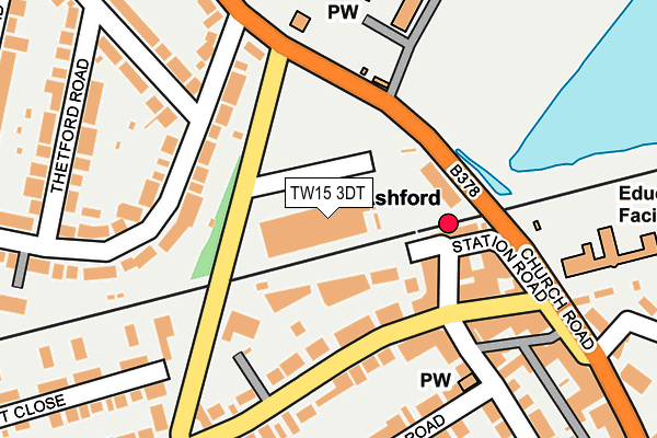
TW15 3DT is located in the Ashford Town electoral ward, within the local authority district of Spelthorne and the English Parliamentary constituency of Spelthorne. The Sub Integrated Care Board (ICB) Location is NHS Surrey Heartlands ICB - 92A and the police force is Surrey. This postcode has been in use since January 1992.


GetTheData
Source: OS OpenMap – Local (Ordnance Survey)
Source: OS VectorMap District (Ordnance Survey)
Licence: Open Government Licence (requires attribution)
| Easting | 506434 |
| Northing | 171939 |
| Latitude | 51.436461 |
| Longitude | -0.470152 |
GetTheData
Source: Open Postcode Geo
Licence: Open Government Licence
| Country | England |
| Postcode District | TW15 |
| ➜ TW15 open data dashboard ➜ See where TW15 is on a map ➜ Where is Ashford? | |
GetTheData
Source: Land Registry Price Paid Data
Licence: Open Government Licence
Elevation or altitude of TW15 3DT as distance above sea level:
| Metres | Feet | |
|---|---|---|
| Elevation | 20m | 66ft |
Elevation is measured from the approximate centre of the postcode, to the nearest point on an OS contour line from OS Terrain 50, which has contour spacing of ten vertical metres.
➜ How high above sea level am I? Find the elevation of your current position using your device's GPS.
GetTheData
Source: Open Postcode Elevation
Licence: Open Government Licence
| Ward | Ashford Town |
| Constituency | Spelthorne |
GetTheData
Source: ONS Postcode Database
Licence: Open Government Licence
| January 2024 | Other theft | On or near Parking Area | 104m |
| December 2023 | Violence and sexual offences | On or near Parking Area | 104m |
| November 2022 | Violence and sexual offences | On or near Parking Area | 104m |
| ➜ Get more crime data in our Crime section | |||
GetTheData
Source: data.police.uk
Licence: Open Government Licence
| Ashford Railway Station (Woodthorpe Road) | Ashford | 124m |
| Ashford Railway Station (Woodthorpe Road) | Ashford | 146m |
| Station Crescent (Church Road) | Ashford | 162m |
| Station Crescent (Stanwell Road) | Ashford | 183m |
| Stanwell Road (Woodthorpe Road) | Ashford | 189m |
| Ashford (Surrey) Station | 0.1km |
| Staines Station | 2.3km |
| Heathrow Terminal 4 Station | 3km |
GetTheData
Source: NaPTAN
Licence: Open Government Licence
GetTheData
Source: ONS Postcode Database
Licence: Open Government Licence


➜ Get more ratings from the Food Standards Agency
GetTheData
Source: Food Standards Agency
Licence: FSA terms & conditions
| Last Collection | |||
|---|---|---|---|
| Location | Mon-Fri | Sat | Distance |
| Station Approach | 18:30 | 12:00 | 135m |
| Knapp Road | 18:30 | 12:00 | 305m |
| Church Road | 18:30 | 340m | |
GetTheData
Source: Dracos
Licence: Creative Commons Attribution-ShareAlike
| Facility | Distance |
|---|---|
| St James' Senior School For Boys Church Road, Ashford Grass Pitches, Sports Hall, Artificial Grass Pitch, Outdoor Tennis Courts | 267m |
| The Thomas Knyvett College Stanwell Road, Ashford Grass Pitches, Sports Hall, Outdoor Tennis Courts | 410m |
| Brooklands College (Ashford Campus) (Closed) Church Road, Ashford Sports Hall, Health and Fitness Gym, Grass Pitches | 548m |
GetTheData
Source: Active Places
Licence: Open Government Licence
| School | Phase of Education | Distance |
|---|---|---|
| St James Senior Boys' School Church Road, Ashford, TW15 3DZ | Not applicable | 267m |
| Fordway Centre Southway, Guildford, GU2 8AA | Not applicable | 291m |
| Clarendon Primary School Knapp Road, Ashford, TW15 2HZ | Primary | 301m |
GetTheData
Source: Edubase
Licence: Open Government Licence
The below table lists the International Territorial Level (ITL) codes (formerly Nomenclature of Territorial Units for Statistics (NUTS) codes) and Local Administrative Units (LAU) codes for TW15 3DT:
| ITL 1 Code | Name |
|---|---|
| TLJ | South East (England) |
| ITL 2 Code | Name |
| TLJ2 | Surrey, East and West Sussex |
| ITL 3 Code | Name |
| TLJ25 | West Surrey |
| LAU 1 Code | Name |
| E07000213 | Spelthorne |
GetTheData
Source: ONS Postcode Directory
Licence: Open Government Licence
The below table lists the Census Output Area (OA), Lower Layer Super Output Area (LSOA), and Middle Layer Super Output Area (MSOA) for TW15 3DT:
| Code | Name | |
|---|---|---|
| OA | E00156627 | |
| LSOA | E01030712 | Spelthorne 003C |
| MSOA | E02006405 | Spelthorne 003 |
GetTheData
Source: ONS Postcode Directory
Licence: Open Government Licence
| TW15 2AU | Woodthorpe Road | 89m |
| TW15 3HH | Station Crescent | 94m |
| TW15 2RP | Woodthorpe Road | 102m |
| TW15 2SA | Woodthorpe Road | 115m |
| TW15 3JJ | Station Crescent | 129m |
| TW15 2QN | Station Approach | 141m |
| TW15 2RH | Woodthorpe Road | 151m |
| TW15 2RU | Woodthorpe Road | 169m |
| TW15 2UR | Station Road | 169m |
| TW15 2RX | Station Parade | 173m |
GetTheData
Source: Open Postcode Geo; Land Registry Price Paid Data
Licence: Open Government Licence