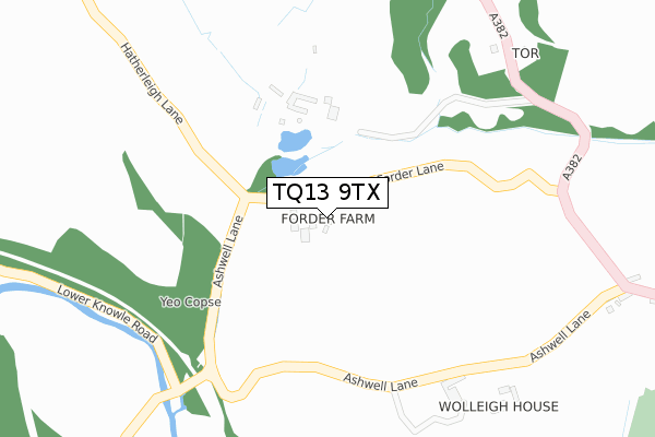
TQ13 9TX is located in the Bovey electoral ward, within the local authority district of Teignbridge and the English Parliamentary constituency of Central Devon. The Sub Integrated Care Board (ICB) Location is NHS Devon ICB - 15N and the police force is Devon & Cornwall. This postcode has been in use since July 2004.


GetTheData
Source: OS Open Zoomstack (Ordnance Survey)
Licence: Open Government Licence (requires attribution)
Attribution: Contains OS data © Crown copyright and database right 2024
Source: Open Postcode Geo
Licence: Open Government Licence (requires attribution)
Attribution: Contains OS data © Crown copyright and database right 2024; Contains Royal Mail data © Royal Mail copyright and database right 2024; Source: Office for National Statistics licensed under the Open Government Licence v.3.0
| Easting | 280098 |
| Northing | 79974 |
| Latitude | 50.607126 |
| Longitude | -3.695835 |
GetTheData
Source: Open Postcode Geo
Licence: Open Government Licence
| Country | England |
| Postcode District | TQ13 |
| ➜ TQ13 open data dashboard ➜ See where TQ13 is on a map | |
GetTheData
Source: Land Registry Price Paid Data
Licence: Open Government Licence
Elevation or altitude of TQ13 9TX as distance above sea level:
| Metres | Feet | |
|---|---|---|
| Elevation | 70m | 230ft |
Elevation is measured from the approximate centre of the postcode, to the nearest point on an OS contour line from OS Terrain 50, which has contour spacing of ten vertical metres.
➜ How high above sea level am I? Find the elevation of your current position using your device's GPS.
GetTheData
Source: Open Postcode Elevation
Licence: Open Government Licence
| Ward | Bovey |
| Constituency | Central Devon |
GetTheData
Source: ONS Postcode Database
Licence: Open Government Licence
| Hawkmoor Cottages (A382) | Wreyland | 610m |
| Hawkmoor Cottages (A382) | Wreyland | 620m |
| Slade Cross (A382) | Wreyland | 1,245m |
| Slade Cross (A382) | Wreyland | 1,250m |
| Gypsy Corner | Wreyland | 1,470m |
GetTheData
Source: NaPTAN
Licence: Open Government Licence
| Percentage of properties with Next Generation Access | 100.0% |
| Percentage of properties with Superfast Broadband | 0.0% |
| Percentage of properties with Ultrafast Broadband | 0.0% |
| Percentage of properties with Full Fibre Broadband | 0.0% |
Superfast Broadband is between 30Mbps and 300Mbps
Ultrafast Broadband is > 300Mbps
| Percentage of properties unable to receive 2Mbps | 0.0% |
| Percentage of properties unable to receive 5Mbps | 0.0% |
| Percentage of properties unable to receive 10Mbps | 100.0% |
| Percentage of properties unable to receive 30Mbps | 100.0% |
GetTheData
Source: Ofcom
Licence: Ofcom Terms of Use (requires attribution)
GetTheData
Source: ONS Postcode Database
Licence: Open Government Licence


➜ Get more ratings from the Food Standards Agency
GetTheData
Source: Food Standards Agency
Licence: FSA terms & conditions
| Last Collection | |||
|---|---|---|---|
| Location | Mon-Fri | Sat | Distance |
| Wolleigh | 15:15 | 09:30 | 480m |
| Shewte Cross | 16:15 | 08:00 | 1,199m |
| Ashburton Post Office | 17:30 | 12:30 | 2,154m |
GetTheData
Source: Dracos
Licence: Creative Commons Attribution-ShareAlike
| Facility | Distance |
|---|---|
| Bovey Tracey Golf Centre Moretonhampstead Road, Bovey Tracey, Newton Abbot Golf | 849m |
| Bullands Park Monks Way, Bovey Tracey, Newton Abbot Grass Pitches | 1.7km |
| Mill Marsh Park St Johns Lane, Bovey Tracey Grass Pitches | 1.9km |
GetTheData
Source: Active Places
Licence: Open Government Licence
| School | Phase of Education | Distance |
|---|---|---|
| Bovey Tracey Primary School Abbey Road, Bovey Tracey, Newton Abbot, TQ13 9HZ | Primary | 1.9km |
| Hennock Community Primary School Hennock, Bovey Tracey, Newton Abbot, TQ13 9QB | Primary | 3.2km |
| Ilsington Church of England Primary School Ilsington, Newton Abbot, TQ13 9RE | Primary | 4.1km |
GetTheData
Source: Edubase
Licence: Open Government Licence
The below table lists the International Territorial Level (ITL) codes (formerly Nomenclature of Territorial Units for Statistics (NUTS) codes) and Local Administrative Units (LAU) codes for TQ13 9TX:
| ITL 1 Code | Name |
|---|---|
| TLK | South West (England) |
| ITL 2 Code | Name |
| TLK4 | Devon |
| ITL 3 Code | Name |
| TLK43 | Devon CC |
| LAU 1 Code | Name |
| E07000045 | Teignbridge |
GetTheData
Source: ONS Postcode Directory
Licence: Open Government Licence
The below table lists the Census Output Area (OA), Lower Layer Super Output Area (LSOA), and Middle Layer Super Output Area (MSOA) for TQ13 9TX:
| Code | Name | |
|---|---|---|
| OA | E00102337 | |
| LSOA | E01020205 | Teignbridge 003A |
| MSOA | E02004203 | Teignbridge 003 |
GetTheData
Source: ONS Postcode Directory
Licence: Open Government Licence
| TQ13 9NH | 363m | |
| TQ13 9NG | 390m | |
| TQ13 9NJ | Hawkmoor Cottages | 632m |
| TQ13 9NQ | Forder Gardens | 651m |
| TQ13 9NE | 871m | |
| TQ13 9NL | Hawkmoor Parke | 930m |
| TQ13 9NN | 931m | |
| TQ13 9SP | Knowle Road | 1116m |
| TQ13 9LH | 1148m | |
| TQ13 9LQ | 1213m |
GetTheData
Source: Open Postcode Geo; Land Registry Price Paid Data
Licence: Open Government Licence