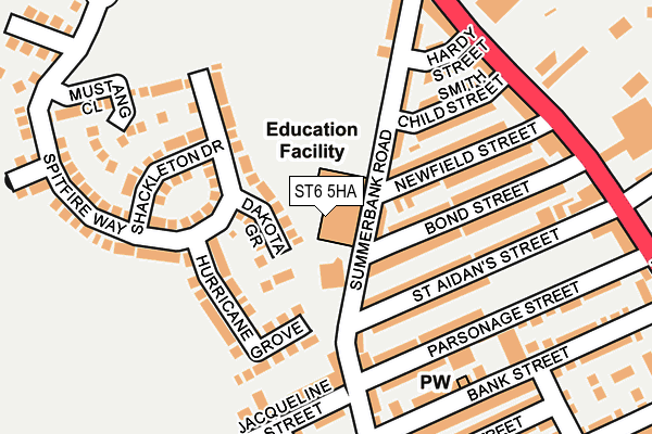
ST6 5HA is located in the Goldenhill & Sandyford electoral ward, within the unitary authority of Stoke-on-Trent and the English Parliamentary constituency of Stoke-on-Trent North. The Sub Integrated Care Board (ICB) Location is NHS Staffordshire and Stoke-on-Trent ICB - 05W and the police force is Staffordshire. This postcode has been in use since January 1980.


GetTheData
Source: OS OpenMap – Local (Ordnance Survey)
Source: OS VectorMap District (Ordnance Survey)
Licence: Open Government Licence (requires attribution)
| Easting | 385544 |
| Northing | 351896 |
| Latitude | 53.064126 |
| Longitude | -2.217171 |
GetTheData
Source: Open Postcode Geo
Licence: Open Government Licence
| Country | England |
| Postcode District | ST6 |
➜ See where ST6 is on a map ➜ Where is Stoke-on-Trent? | |
GetTheData
Source: Land Registry Price Paid Data
Licence: Open Government Licence
Elevation or altitude of ST6 5HA as distance above sea level:
| Metres | Feet | |
|---|---|---|
| Elevation | 180m | 591ft |
Elevation is measured from the approximate centre of the postcode, to the nearest point on an OS contour line from OS Terrain 50, which has contour spacing of ten vertical metres.
➜ How high above sea level am I? Find the elevation of your current position using your device's GPS.
GetTheData
Source: Open Postcode Elevation
Licence: Open Government Licence
| Ward | Goldenhill & Sandyford |
| Constituency | Stoke-on-trent North |
GetTheData
Source: ONS Postcode Database
Licence: Open Government Licence
| Summerbank Road (High Street) | Tunstall | 183m |
| Summerbank Road (High Street) | Tunstall | 198m |
| Parsonage Street (High Street) | Tunstall | 317m |
| Newfield (High Street) | Sandyford | 338m |
| Parsonage Street (High Street) | Tunstall | 377m |
| Longport Station | 2.5km |
| Kidsgrove Station | 3.1km |
GetTheData
Source: NaPTAN
Licence: Open Government Licence
GetTheData
Source: ONS Postcode Database
Licence: Open Government Licence


➜ Get more ratings from the Food Standards Agency
GetTheData
Source: Food Standards Agency
Licence: FSA terms & conditions
| Last Collection | |||
|---|---|---|---|
| Location | Mon-Fri | Sat | Distance |
| Tower Square | 18:00 | 751m | |
| Tower Square | 18:00 | 12:15 | 753m |
| Tunstall Post Office | 18:00 | 12:00 | 834m |
GetTheData
Source: Dracos
Licence: Creative Commons Attribution-ShareAlike
The below table lists the International Territorial Level (ITL) codes (formerly Nomenclature of Territorial Units for Statistics (NUTS) codes) and Local Administrative Units (LAU) codes for ST6 5HA:
| ITL 1 Code | Name |
|---|---|
| TLG | West Midlands (England) |
| ITL 2 Code | Name |
| TLG2 | Shropshire and Staffordshire |
| ITL 3 Code | Name |
| TLG23 | Stoke-on-Trent |
| LAU 1 Code | Name |
| E06000021 | Stoke-on-Trent |
GetTheData
Source: ONS Postcode Directory
Licence: Open Government Licence
The below table lists the Census Output Area (OA), Lower Layer Super Output Area (LSOA), and Middle Layer Super Output Area (MSOA) for ST6 5HA:
| Code | Name | |
|---|---|---|
| OA | E00072511 | |
| LSOA | E01014361 | Stoke-on-Trent 005D |
| MSOA | E02002955 | Stoke-on-Trent 005 |
GetTheData
Source: ONS Postcode Directory
Licence: Open Government Licence
| ST6 5EY | Summerbank Road | 83m |
| ST6 5XW | Dakota Grove | 98m |
| ST6 5HD | Newfield Street | 122m |
| ST6 5HB | Smith Child Street | 136m |
| ST6 5XH | Shackleton Drive | 142m |
| ST6 5EX | Hardy Street | 143m |
| ST6 5HG | Bond Street | 149m |
| ST6 5HF | Bond Street | 156m |
| ST6 5HH | St Aidans Street | 160m |
| ST6 5XJ | Hurricane Grove | 166m |
GetTheData
Source: Open Postcode Geo; Land Registry Price Paid Data
Licence: Open Government Licence