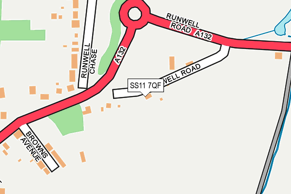
SS11 7QF lies on Runwell Road in Runwell, Wickford. SS11 7QF is located in the Rettendon and Runwell electoral ward, within the local authority district of Chelmsford and the English Parliamentary constituency of Maldon. The Sub Integrated Care Board (ICB) Location is NHS Mid and South Essex ICB - 06Q and the police force is Essex. This postcode has been in use since January 1980.


GetTheData
Source: OS OpenMap – Local (Ordnance Survey)
Source: OS VectorMap District (Ordnance Survey)
Licence: Open Government Licence (requires attribution)
| Easting | 576136 |
| Northing | 194872 |
| Latitude | 51.625102 |
| Longitude | 0.543235 |
GetTheData
Source: Open Postcode Geo
Licence: Open Government Licence
| Street | Runwell Road |
| Locality | Runwell |
| Town/City | Wickford |
| Country | England |
| Postcode District | SS11 |
➜ See where SS11 is on a map ➜ Where is Runwell? | |
GetTheData
Source: Land Registry Price Paid Data
Licence: Open Government Licence
Elevation or altitude of SS11 7QF as distance above sea level:
| Metres | Feet | |
|---|---|---|
| Elevation | 20m | 66ft |
Elevation is measured from the approximate centre of the postcode, to the nearest point on an OS contour line from OS Terrain 50, which has contour spacing of ten vertical metres.
➜ How high above sea level am I? Find the elevation of your current position using your device's GPS.
GetTheData
Source: Open Postcode Elevation
Licence: Open Government Licence
| Ward | Rettendon And Runwell |
| Constituency | Maldon |
GetTheData
Source: ONS Postcode Database
Licence: Open Government Licence
HIGHOVER COTTAGE, RUNWELL ROAD, RUNWELL, WICKFORD, SS11 7QF 2020 14 AUG £585,000 |
2017 23 MAR £527,000 |
2005 8 DEC £320,000 |
GetTheData
Source: HM Land Registry Price Paid Data
Licence: Contains HM Land Registry data © Crown copyright and database right 2025. This data is licensed under the Open Government Licence v3.0.
| The Chase (A132) | Runwell | 162m |
| The Chase (Runwell Road) | Runwell | 200m |
| Lynfords Drive (Runwell Road (A132)) | Runwell | 364m |
| Lynfords Drive (Runwell Road) | Runwell | 422m |
| Church (Runwell Road) | Runwell | 869m |
| Battlesbridge Station | 1.5km |
| Wickford Station | 2km |
| South Woodham Ferrers Station | 5.2km |
GetTheData
Source: NaPTAN
Licence: Open Government Licence
| Percentage of properties with Next Generation Access | 100.0% |
| Percentage of properties with Superfast Broadband | 100.0% |
| Percentage of properties with Ultrafast Broadband | 0.0% |
| Percentage of properties with Full Fibre Broadband | 0.0% |
Superfast Broadband is between 30Mbps and 300Mbps
Ultrafast Broadband is > 300Mbps
| Percentage of properties unable to receive 2Mbps | 0.0% |
| Percentage of properties unable to receive 5Mbps | 0.0% |
| Percentage of properties unable to receive 10Mbps | 0.0% |
| Percentage of properties unable to receive 30Mbps | 0.0% |
GetTheData
Source: Ofcom
Licence: Ofcom Terms of Use (requires attribution)
GetTheData
Source: ONS Postcode Database
Licence: Open Government Licence


➜ Get more ratings from the Food Standards Agency
GetTheData
Source: Food Standards Agency
Licence: FSA terms & conditions
| Last Collection | |||
|---|---|---|---|
| Location | Mon-Fri | Sat | Distance |
| Shotgate Post Office | 18:30 | 11:15 | 1,719m |
| Station Approach | 17:30 | 12:00 | 1,994m |
| Halls Corner | 17:30 | 11:30 | 2,227m |
GetTheData
Source: Dracos
Licence: Creative Commons Attribution-ShareAlike
The below table lists the International Territorial Level (ITL) codes (formerly Nomenclature of Territorial Units for Statistics (NUTS) codes) and Local Administrative Units (LAU) codes for SS11 7QF:
| ITL 1 Code | Name |
|---|---|
| TLH | East |
| ITL 2 Code | Name |
| TLH3 | Essex |
| ITL 3 Code | Name |
| TLH36 | Heart of Essex |
| LAU 1 Code | Name |
| E07000070 | Chelmsford |
GetTheData
Source: ONS Postcode Directory
Licence: Open Government Licence
The below table lists the Census Output Area (OA), Lower Layer Super Output Area (LSOA), and Middle Layer Super Output Area (MSOA) for SS11 7QF:
| Code | Name | |
|---|---|---|
| OA | E00109701 | |
| LSOA | E01021595 | Chelmsford 021C |
| MSOA | E02004505 | Chelmsford 021 |
GetTheData
Source: ONS Postcode Directory
Licence: Open Government Licence
| SS11 7PU | Runwell Chase | 159m |
| SS11 7PT | Browns Avenue | 178m |
| SS11 7PS | Runwell Road | 250m |
| SS11 7PR | Barnet Park Road | 312m |
| SS11 7QH | Runwell Road | 331m |
| SS11 7PP | Lynfords Drive | 350m |
| SS11 7PN | Runwell Road | 641m |
| SS11 7QJ | Runwell Road | 764m |
| SS11 7DX | Meadow Lane | 878m |
| SS11 8LN | Whist Avenue | 878m |
GetTheData
Source: Open Postcode Geo; Land Registry Price Paid Data
Licence: Open Government Licence