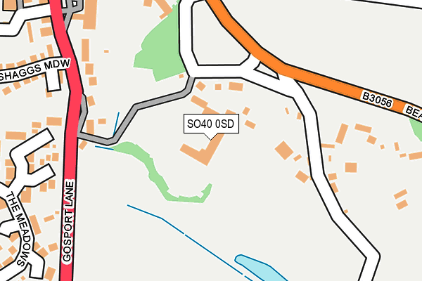
SO40 0SD is located in the Lyndhurst & Minstead electoral ward, within the local authority district of New Forest and the English Parliamentary constituency of New Forest East. The Sub Integrated Care Board (ICB) Location is NHS Hampshire and Isle of Wight ICB - D9Y0V and the police force is Hampshire. This postcode has been in use since February 2005.


GetTheData
Source: OS OpenMap – Local (Ordnance Survey)
Source: OS VectorMap District (Ordnance Survey)
Licence: Open Government Licence (requires attribution)
| Easting | 430311 |
| Northing | 107932 |
| Latitude | 50.870100 |
| Longitude | -1.570615 |
GetTheData
Source: Open Postcode Geo
Licence: Open Government Licence
| Country | England |
| Postcode District | SO40 |
➜ See where SO40 is on a map ➜ Where is Lyndhurst? | |
GetTheData
Source: Land Registry Price Paid Data
Licence: Open Government Licence
Elevation or altitude of SO40 0SD as distance above sea level:
| Metres | Feet | |
|---|---|---|
| Elevation | 40m | 131ft |
Elevation is measured from the approximate centre of the postcode, to the nearest point on an OS contour line from OS Terrain 50, which has contour spacing of ten vertical metres.
➜ How high above sea level am I? Find the elevation of your current position using your device's GPS.
GetTheData
Source: Open Postcode Elevation
Licence: Open Government Licence
| Ward | Lyndhurst & Minstead |
| Constituency | New Forest East |
GetTheData
Source: ONS Postcode Database
Licence: Open Government Licence
| War Memorial (Off Beaulieu Road) | Lyndhurst | 216m |
| Lyndhurst Park Hotel (High Street) | Lyndhurst | 252m |
| Lyndhurst Park Hotel (High Street) | Lyndhurst | 258m |
| Queens Road (Southampton Road) | Lyndhurst | 398m |
| Library Car Park | Lyndhurst | 403m |
| Ashurst New Forest Station | 3.8km |
| Beaulieu Road Station | 4.9km |
GetTheData
Source: NaPTAN
Licence: Open Government Licence
GetTheData
Source: ONS Postcode Database
Licence: Open Government Licence


➜ Get more ratings from the Food Standards Agency
GetTheData
Source: Food Standards Agency
Licence: FSA terms & conditions
| Last Collection | |||
|---|---|---|---|
| Location | Mon-Fri | Sat | Distance |
| Lyndhurst Post Office | 17:45 | 12:00 | 325m |
| Upper High Street | 17:30 | 12:00 | 472m |
| Upper High Street | 17:30 | 12:00 | 472m |
GetTheData
Source: Dracos
Licence: Creative Commons Attribution-ShareAlike
The below table lists the International Territorial Level (ITL) codes (formerly Nomenclature of Territorial Units for Statistics (NUTS) codes) and Local Administrative Units (LAU) codes for SO40 0SD:
| ITL 1 Code | Name |
|---|---|
| TLJ | South East (England) |
| ITL 2 Code | Name |
| TLJ3 | Hampshire and Isle of Wight |
| ITL 3 Code | Name |
| TLJ36 | Central Hampshire |
| LAU 1 Code | Name |
| E07000091 | New Forest |
GetTheData
Source: ONS Postcode Directory
Licence: Open Government Licence
The below table lists the Census Output Area (OA), Lower Layer Super Output Area (LSOA), and Middle Layer Super Output Area (MSOA) for SO40 0SD:
| Code | Name | |
|---|---|---|
| OA | E00117098 | |
| LSOA | E01023045 | New Forest 007C |
| MSOA | E02004785 | New Forest 007 |
GetTheData
Source: ONS Postcode Directory
Licence: Open Government Licence
| SO43 7EQ | Great Mead Park | 237m |
| SO43 7ER | Gosport Lane | 255m |
| SO43 7BL | Gosport Lane | 282m |
| SO43 7EJ | The Meadows | 295m |
| SO43 7BH | High Street | 299m |
| SO43 7DA | Beaulieu Road | 303m |
| SO43 7BJ | High Street | 306m |
| SO43 7BN | Shaggs Meadow | 335m |
| SO43 7BF | Gosport Lane | 340m |
| SO43 7BP | Gosport Lane | 353m |
GetTheData
Source: Open Postcode Geo; Land Registry Price Paid Data
Licence: Open Government Licence