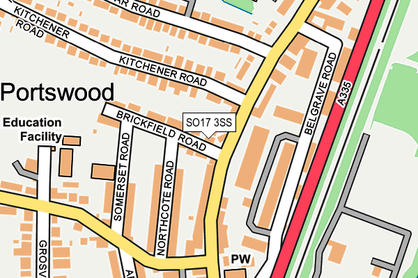
SO17 3SS is located in the Swaythling electoral ward, within the unitary authority of Southampton and the English Parliamentary constituency of Southampton, Test. The Sub Integrated Care Board (ICB) Location is NHS Hampshire and Isle of Wight ICB - D9Y0V and the police force is Hampshire. This postcode has been in use since January 2004.


GetTheData
Source: OS OpenMap – Local (Ordnance Survey)
Source: OS VectorMap District (Ordnance Survey)
Licence: Open Government Licence (requires attribution)
| Easting | 443295 |
| Northing | 114860 |
| Latitude | 50.931572 |
| Longitude | -1.385288 |
GetTheData
Source: Open Postcode Geo
Licence: Open Government Licence
| Country | England |
| Postcode District | SO17 |
| ➜ SO17 open data dashboard ➜ See where SO17 is on a map ➜ Where is Southampton? | |
GetTheData
Source: Land Registry Price Paid Data
Licence: Open Government Licence
Elevation or altitude of SO17 3SS as distance above sea level:
| Metres | Feet | |
|---|---|---|
| Elevation | 10m | 33ft |
Elevation is measured from the approximate centre of the postcode, to the nearest point on an OS contour line from OS Terrain 50, which has contour spacing of ten vertical metres.
➜ How high above sea level am I? Find the elevation of your current position using your device's GPS.
GetTheData
Source: Open Postcode Elevation
Licence: Open Government Licence
| Ward | Swaythling |
| Constituency | Southampton, Test |
GetTheData
Source: ONS Postcode Database
Licence: Open Government Licence
| January 2024 | Burglary | On or near Grosvenor Close | 389m |
| November 2023 | Criminal damage and arson | On or near Grosvenor Close | 389m |
| November 2023 | Other theft | On or near Grosvenor Close | 389m |
| ➜ Get more crime data in our Crime section | |||
GetTheData
Source: data.police.uk
Licence: Open Government Licence
| Sirdar Road (Portswood Road) | Swaythling | 163m |
| Sirdar Road (Portswood Road) | Swaythling | 178m |
| Bowden Lane (Portswood Road) | Portswood | 202m |
| Bowden Lane (Portswood Road) | Portswood | 270m |
| Mayfield Road (Portswood Road) | Swaythling | 326m |
| St Denys Station | 1.1km |
| Swaythling Station | 1.2km |
| Bitterne Station | 1.6km |
GetTheData
Source: NaPTAN
Licence: Open Government Licence
| Percentage of properties with Next Generation Access | 100.0% |
| Percentage of properties with Superfast Broadband | 100.0% |
| Percentage of properties with Ultrafast Broadband | 0.0% |
| Percentage of properties with Full Fibre Broadband | 0.0% |
Superfast Broadband is between 30Mbps and 300Mbps
Ultrafast Broadband is > 300Mbps
| Percentage of properties unable to receive 2Mbps | 0.0% |
| Percentage of properties unable to receive 5Mbps | 0.0% |
| Percentage of properties unable to receive 10Mbps | 0.0% |
| Percentage of properties unable to receive 30Mbps | 0.0% |
GetTheData
Source: Ofcom
Licence: Ofcom Terms of Use (requires attribution)
GetTheData
Source: ONS Postcode Database
Licence: Open Government Licence


➜ Get more ratings from the Food Standards Agency
GetTheData
Source: Food Standards Agency
Licence: FSA terms & conditions
| Last Collection | |||
|---|---|---|---|
| Location | Mon-Fri | Sat | Distance |
| Bowden Lane | 16:00 | 11:15 | 160m |
| Portswood Road Post Office | 18:30 | 12:00 | 297m |
| Grosvenor Road | 16:00 | 12:00 | 341m |
GetTheData
Source: Dracos
Licence: Creative Commons Attribution-ShareAlike
| Facility | Distance |
|---|---|
| Portswood Recreation Ground Upper Grosvenor Road, Southampton Outdoor Tennis Courts | 291m |
| The Gym Group (Southampton Portswood) Portswood Road, Southampton Health and Fitness Gym | 609m |
| Bitterne Park Primary School Manor Farm Road, Southampton Grass Pitches | 614m |
GetTheData
Source: Active Places
Licence: Open Government Licence
| School | Phase of Education | Distance |
|---|---|---|
| Portswood Primary School Somerset Road, Southampton, SO17 3AA | Primary | 208m |
| Bitterne Park Primary School Manor Farm Road, Bitterne Park, Southampton, SO18 1NX | Primary | 636m |
| Swaythling Primary School Mayfield Road, Southampton, SO17 3SZ | Primary | 655m |
GetTheData
Source: Edubase
Licence: Open Government Licence
The below table lists the International Territorial Level (ITL) codes (formerly Nomenclature of Territorial Units for Statistics (NUTS) codes) and Local Administrative Units (LAU) codes for SO17 3SS:
| ITL 1 Code | Name |
|---|---|
| TLJ | South East (England) |
| ITL 2 Code | Name |
| TLJ3 | Hampshire and Isle of Wight |
| ITL 3 Code | Name |
| TLJ32 | Southampton |
| LAU 1 Code | Name |
| E06000045 | Southampton |
GetTheData
Source: ONS Postcode Directory
Licence: Open Government Licence
The below table lists the Census Output Area (OA), Lower Layer Super Output Area (LSOA), and Middle Layer Super Output Area (MSOA) for SO17 3SS:
| Code | Name | |
|---|---|---|
| OA | E00087032 | |
| LSOA | E01017231 | Southampton 009D |
| MSOA | E02003557 | Southampton 009 |
GetTheData
Source: ONS Postcode Directory
Licence: Open Government Licence
| SO17 3AF | Brickfield Road | 32m |
| SO17 3SE | Portswood Road | 62m |
| SO17 3SA | Portswood Road | 83m |
| SO17 3AE | Brickfield Road | 84m |
| SO17 3SB | Portswood Road | 91m |
| SO17 3SL | Portswood Road | 106m |
| SO17 3AH | Northcote Road | 119m |
| SO17 3AG | Northcote Road | 123m |
| SO17 3SF | Kitchener Road | 135m |
| SO17 3AD | Brickfield Road | 148m |
GetTheData
Source: Open Postcode Geo; Land Registry Price Paid Data
Licence: Open Government Licence