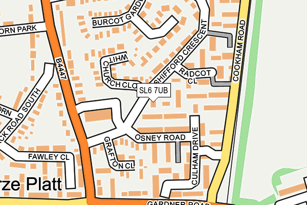
SL6 7UB is located in the Furze Platt electoral ward, within the unitary authority of Windsor and Maidenhead and the English Parliamentary constituency of Maidenhead. The Sub Integrated Care Board (ICB) Location is NHS Frimley ICB - D4U1Y and the police force is Thames Valley. This postcode has been in use since April 1985.


GetTheData
Source: OS OpenMap – Local (Ordnance Survey)
Source: OS VectorMap District (Ordnance Survey)
Licence: Open Government Licence (requires attribution)
| Easting | 488212 |
| Northing | 183008 |
| Latitude | 51.539090 |
| Longitude | -0.729486 |
GetTheData
Source: Open Postcode Geo
Licence: Open Government Licence
| Country | England |
| Postcode District | SL6 |
| ➜ SL6 open data dashboard ➜ See where SL6 is on a map ➜ Where is Maidenhead? | |
GetTheData
Source: Land Registry Price Paid Data
Licence: Open Government Licence
Elevation or altitude of SL6 7UB as distance above sea level:
| Metres | Feet | |
|---|---|---|
| Elevation | 40m | 131ft |
Elevation is measured from the approximate centre of the postcode, to the nearest point on an OS contour line from OS Terrain 50, which has contour spacing of ten vertical metres.
➜ How high above sea level am I? Find the elevation of your current position using your device's GPS.
GetTheData
Source: Open Postcode Elevation
Licence: Open Government Licence
| Ward | Furze Platt |
| Constituency | Maidenhead |
GetTheData
Source: ONS Postcode Database
Licence: Open Government Licence
| December 2023 | Violence and sexual offences | On or near Switchback Road South | 425m |
| December 2023 | Violence and sexual offences | On or near Switchback Road South | 425m |
| December 2023 | Vehicle crime | On or near Gloucester Road | 496m |
| ➜ Get more crime data in our Crime section | |||
GetTheData
Source: data.police.uk
Licence: Open Government Licence
| Switchback Road Shops (Switchback Road North) | Furze Platt | 168m |
| Spencers Bridge (Gardner Road) | Furze Platt | 196m |
| Spencers Bridge (Gardner Road) | Furze Platt | 201m |
| Kinghorn Park (Switchback Road North) | Furze Platt | 216m |
| Kinghorn Park (Switchback Road North) | Furze Platt | 259m |
| Furze Platt Station | 0.7km |
| Cookham Station | 2.1km |
| Maidenhead Station | 2.3km |
GetTheData
Source: NaPTAN
Licence: Open Government Licence
| Percentage of properties with Next Generation Access | 100.0% |
| Percentage of properties with Superfast Broadband | 100.0% |
| Percentage of properties with Ultrafast Broadband | 100.0% |
| Percentage of properties with Full Fibre Broadband | 0.0% |
Superfast Broadband is between 30Mbps and 300Mbps
Ultrafast Broadband is > 300Mbps
| Percentage of properties unable to receive 2Mbps | 0.0% |
| Percentage of properties unable to receive 5Mbps | 0.0% |
| Percentage of properties unable to receive 10Mbps | 0.0% |
| Percentage of properties unable to receive 30Mbps | 0.0% |
GetTheData
Source: Ofcom
Licence: Ofcom Terms of Use (requires attribution)
GetTheData
Source: ONS Postcode Database
Licence: Open Government Licence


➜ Get more ratings from the Food Standards Agency
GetTheData
Source: Food Standards Agency
Licence: FSA terms & conditions
| Last Collection | |||
|---|---|---|---|
| Location | Mon-Fri | Sat | Distance |
| Shifford Crescent | 17:15 | 11:30 | 25m |
| Switchback Road North | 17:15 | 11:30 | 223m |
| Aldebury Road | 17:00 | 11:30 | 442m |
GetTheData
Source: Dracos
Licence: Creative Commons Attribution-ShareAlike
| Facility | Distance |
|---|---|
| Summerleaze Park North Town Moor, Maidenhead Grass Pitches | 718m |
| Laggan Field Laggan Road, Maidenhead Grass Pitches | 745m |
| Furze Platt Senior School Furze Platt Road, Maidenhead Grass Pitches, Sports Hall, Studio, Artificial Grass Pitch, Health and Fitness Gym | 886m |
GetTheData
Source: Active Places
Licence: Open Government Licence
| School | Phase of Education | Distance |
|---|---|---|
| Maidenhead Nursery School School Lane, Maidenhead, SL6 7PG | Nursery | 606m |
| Furze Platt Senior School Furze Platt Road, Maidenhead, SL6 7NQ | Secondary | 853m |
| St Mary's Catholic Primary School, Maidenhead Cookham Road, Maidenhead, SL6 7EG | Primary | 909m |
GetTheData
Source: Edubase
Licence: Open Government Licence
The below table lists the International Territorial Level (ITL) codes (formerly Nomenclature of Territorial Units for Statistics (NUTS) codes) and Local Administrative Units (LAU) codes for SL6 7UB:
| ITL 1 Code | Name |
|---|---|
| TLJ | South East (England) |
| ITL 2 Code | Name |
| TLJ1 | Berkshire, Buckinghamshire and Oxfordshire |
| ITL 3 Code | Name |
| TLJ11 | Berkshire |
| LAU 1 Code | Name |
| E06000040 | Windsor and Maidenhead |
GetTheData
Source: ONS Postcode Directory
Licence: Open Government Licence
The below table lists the Census Output Area (OA), Lower Layer Super Output Area (LSOA), and Middle Layer Super Output Area (MSOA) for SL6 7UB:
| Code | Name | |
|---|---|---|
| OA | E00083678 | |
| LSOA | E01016573 | Windsor and Maidenhead 003B |
| MSOA | E02003423 | Windsor and Maidenhead 003 |
GetTheData
Source: ONS Postcode Directory
Licence: Open Government Licence
| SL6 7UH | Hambleden Walk | 83m |
| SL6 7UQ | Osney Road | 95m |
| SL6 7UW | Shifford Crescent | 100m |
| SL6 7TZ | Whitchurch Close | 107m |
| SL6 7UY | Shifford Crescent | 139m |
| SL6 7UE | Switchback Road North | 141m |
| SL6 7PW | Culham Drive | 152m |
| SL6 7UR | Burcot Gardens | 158m |
| SL6 7UG | Grafton Close | 159m |
| SL6 7UF | Switchback Road North | 175m |
GetTheData
Source: Open Postcode Geo; Land Registry Price Paid Data
Licence: Open Government Licence