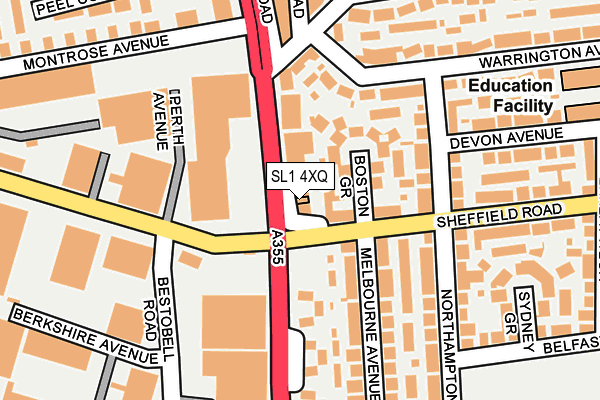
SL1 4XQ is located in the Baylis & Salt Hill electoral ward, within the unitary authority of Slough and the English Parliamentary constituency of Slough. The Sub Integrated Care Board (ICB) Location is NHS Frimley ICB - D4U1Y and the police force is Thames Valley. This postcode has been in use since January 1980.


GetTheData
Source: OS OpenMap – Local (Ordnance Survey)
Source: OS VectorMap District (Ordnance Survey)
Licence: Open Government Licence (requires attribution)
| Easting | 496197 |
| Northing | 181332 |
| Latitude | 51.522722 |
| Longitude | -0.614844 |
GetTheData
Source: Open Postcode Geo
Licence: Open Government Licence
| Country | England |
| Postcode District | SL1 |
| ➜ SL1 open data dashboard ➜ See where SL1 is on a map ➜ Where is Slough? | |
GetTheData
Source: Land Registry Price Paid Data
Licence: Open Government Licence
Elevation or altitude of SL1 4XQ as distance above sea level:
| Metres | Feet | |
|---|---|---|
| Elevation | 30m | 98ft |
Elevation is measured from the approximate centre of the postcode, to the nearest point on an OS contour line from OS Terrain 50, which has contour spacing of ten vertical metres.
➜ How high above sea level am I? Find the elevation of your current position using your device's GPS.
GetTheData
Source: Open Postcode Elevation
Licence: Open Government Licence
| Ward | Baylis & Salt Hill |
| Constituency | Slough |
GetTheData
Source: ONS Postcode Database
Licence: Open Government Licence
| April 2023 | Violence and sexual offences | On or near Ely Avenue | 405m |
| February 2023 | Vehicle crime | On or near Ely Avenue | 405m |
| December 2022 | Burglary | On or near Ely Avenue | 405m |
| ➜ Get more crime data in our Crime section | |||
GetTheData
Source: data.police.uk
Licence: Open Government Licence
| Farnham Road Po (Farnham Road) | Slough Trading Estate | 79m |
| Northampton Avenue (Sheffield Road) | Baylis | 96m |
| Berkshire Avenue (Bestobell Road) | Slough Trading Estate | 157m |
| Berkshire Avenue (Bestobell Road) | Slough Trading Estate | 170m |
| Northampton Avenue (Sheffield Road) | Baylis | 172m |
| Slough Station | 2km |
| Burnham (Berks) Station | 2.2km |
| Windsor & Eton Riverside Station | 4.2km |
GetTheData
Source: NaPTAN
Licence: Open Government Licence
GetTheData
Source: ONS Postcode Database
Licence: Open Government Licence


➜ Get more ratings from the Food Standards Agency
GetTheData
Source: Food Standards Agency
Licence: FSA terms & conditions
| Last Collection | |||
|---|---|---|---|
| Location | Mon-Fri | Sat | Distance |
| Farnham Road | 17:15 | 12:00 | 2m |
| Montrose Avenue Slough | 17:45 | 12:45 | 357m |
| Oatlands Drive | 18:45 | 11:15 | 418m |
GetTheData
Source: Dracos
Licence: Creative Commons Attribution-ShareAlike
| Facility | Distance |
|---|---|
| Phoenix Infant Academy Warrington Avenue, Slough Sports Hall, Studio | 308m |
| The Centre (Slough) Farnham Road, Slough Sports Hall, Health and Fitness Gym, Swimming Pool, Studio | 335m |
| Herschel Grammar School Northampton Avenue, Slough Grass Pitches, Athletics | 407m |
GetTheData
Source: Active Places
Licence: Open Government Licence
| School | Phase of Education | Distance |
|---|---|---|
| Phoenix Infant Academy Warrington Avenue, Slough, SL1 3BQ | Primary | 309m |
| Slough Centre Nursery School Buckingham Avenue East, Slough, SL1 3EA | Nursery | 364m |
| Baylis Court Nursery School Oatlands Drive, Slough, SL1 3HS | Nursery | 401m |
GetTheData
Source: Edubase
Licence: Open Government Licence
The below table lists the International Territorial Level (ITL) codes (formerly Nomenclature of Territorial Units for Statistics (NUTS) codes) and Local Administrative Units (LAU) codes for SL1 4XQ:
| ITL 1 Code | Name |
|---|---|
| TLJ | South East (England) |
| ITL 2 Code | Name |
| TLJ1 | Berkshire, Buckinghamshire and Oxfordshire |
| ITL 3 Code | Name |
| TLJ11 | Berkshire |
| LAU 1 Code | Name |
| E06000039 | Slough |
GetTheData
Source: ONS Postcode Directory
Licence: Open Government Licence
The below table lists the Census Output Area (OA), Lower Layer Super Output Area (LSOA), and Middle Layer Super Output Area (MSOA) for SL1 4XQ:
| Code | Name | |
|---|---|---|
| OA | E00083251 | |
| LSOA | E01016483 | Slough 002A |
| MSOA | E02003408 | Slough 002 |
GetTheData
Source: ONS Postcode Directory
Licence: Open Government Licence
| SL1 4XE | Farnham Road | 49m |
| SL1 3EQ | Boston Grove | 59m |
| SL1 3EG | Sheffield Road | 74m |
| SL1 3BD | Warrington Avenue | 129m |
| SL1 3BL | Northampton Avenue | 129m |
| SL1 3AZ | Gloucester Avenue | 141m |
| SL1 3ED | Melbourne Avenue | 151m |
| SL1 3BH | Northampton Avenue | 158m |
| SL1 3BE | Warrington Avenue | 163m |
| SL1 4XA | Farnham Road | 169m |
GetTheData
Source: Open Postcode Geo; Land Registry Price Paid Data
Licence: Open Government Licence